geo.wikisort.org - River
The Vishera (Russian: Вишера) is a river in Malovishersky and Novgorodsky Districts, Novgorod Oblast, Russia, a right tributary of the Maly Volkhovets, an eastern armlet of the Volkhov. It is 64 kilometres (40 mi) long, and the area of its basin 1,100 square kilometres (420 sq mi).[1]
| Vishera Russian: Вишера | |
|---|---|
 The Vishera in the village of Savino | |
| Location | |
| Country | Russia |
| Physical characteristics | |
| Mouth | Maly Volkhovets |
• coordinates | 58°33′44″N 31°24′14″E |
| Length | 64 km (40 mi) |
| Basin size | 1,100 km2 (420 sq mi) |
| Basin features | |
| Progression | Maly Volkhovets→ Volkhov→ Lake Ladoga→ Neva→ Gulf of Finland |
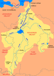
The Vishera river originates from the confluence of the Malaya Vishera (left) and the Bolshaya Vishera (right) several kilometers southwest of the town of Malaya Vishera, close to the border of Malovishersky and Novgorodsky Districts. From the confluence, the Vishera flows southwest and enters Novgorodsky District. Its mouth is located approximately 10 kilometres (6.2 mi) east of the city of Veliky Novgorod.
References
Wikimedia Commons has media related to Category:Vishera river, Novgorod Oblast.
- "Body of water in the State Water Register of Russia". textual.ru (in Russian).
На других языках
- [en] Vishera (Novgorod Oblast)
[ru] Вишера (приток Малого Волховца)
Ви́шера — река в Новгородской области, впадает в правый рукав Волхова — Малый Волховец в районе деревни Сперанская Мыза. В начале XX века была судоходна на протяжении 8 вёрст от устья до Вишерского канала[2].Текст в блоке "Читать" взят с сайта "Википедия" и доступен по лицензии Creative Commons Attribution-ShareAlike; в отдельных случаях могут действовать дополнительные условия.
Другой контент может иметь иную лицензию. Перед использованием материалов сайта WikiSort.org внимательно изучите правила лицензирования конкретных элементов наполнения сайта.
Другой контент может иметь иную лицензию. Перед использованием материалов сайта WikiSort.org внимательно изучите правила лицензирования конкретных элементов наполнения сайта.
2019-2026
WikiSort.org - проект по пересортировке и дополнению контента Википедии
WikiSort.org - проект по пересортировке и дополнению контента Википедии