geo.wikisort.org - River
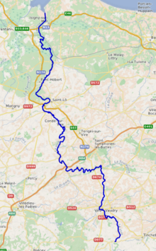
The Vire (French pronunciation: [viʁ] (![]() listen)) is a river in Normandy, France whose 128 km (80 mi) course crosses the départements of Calvados and Manche, flowing through the towns of Vire, Saint-Lô and Isigny-sur-Mer,[1] finally flowing out into the English Channel. Its main tributaries are the Aure, the Elle and the Souleuvre.
listen)) is a river in Normandy, France whose 128 km (80 mi) course crosses the départements of Calvados and Manche, flowing through the towns of Vire, Saint-Lô and Isigny-sur-Mer,[1] finally flowing out into the English Channel. Its main tributaries are the Aure, the Elle and the Souleuvre.
| Vire | |
|---|---|
 Vire at Pont-Farcy | |
 | |
| Native name | La Vire (French) |
| Location | |
| Country | France |
| Physical characteristics | |
| Source | |
| • location | Normandy |
| • elevation | 300 m (980 ft) |
| Mouth | |
• location | English Channel |
• coordinates | 49°21′24″N 1°7′13″W |
| Length | 128 km (80 mi) |
| Basin size | 1,240 km2 (480 sq mi) |
The outflow of the Vire has been canalized and forms the port of Isigny-sur-Mer.
The poets of the Vire valley (Vau de Vire) are said to have given rise to vaudeville.[2]
Places along the river:
- Calvados (14) : Vire, Pont-Farcy, Isigny-sur-Mer
- Manche (50) : Tessy-sur-Vire, Troisgots, Torigni-sur-Vire, Condé-sur-Vire, Sainte-Suzanne-sur-Vire, Saint-Lô, Rampan, Pont-Hébert, La Meauffe, Cavigny
Hydrology and water quality
The generally brownish waters of the Vire are moderately alkaline having been tested by Lumina Tech as pH 8.31.[3] The river waters are relatively turbid, with a Secchi disc measurement of 12 centimetres.[citation needed]
Historical significance
At the turn of the 10th century, the territorial lands of the Kingdom of Brittany had been expanded up to the Vire by their king Alan I.
References
- Sandre. "Fiche cours d'eau - La Vire (I4--0200)".
- Burke, James (September 2, 2003). An Invisible Object (Connections3 DVD). Ambrose Video Publishing, Inc.
- Hogan 2006.
External links
- Atlas des Routes de France, Solar Press: Donnees IGN (2007)
- Hogan, C. Michael, Water quality of freshwater bodies in France, Lumina Tech Press, Aberdeen, Scotland (2006)
Authority control | |
|---|---|
| General |
|
| National libraries | |
| Other |
|
This Normandy geography article is a stub. You can help Wikipedia by expanding it. |
На других языках
[de] Vire (Fluss)
Die Vire ist ein Fluss in Frankreich, der in der Region Normandie verläuft. Sie entspringt an der Gemeindegrenze von Chaulieu und Truttemer-le-Petit, entwässert generell Richtung Nord bis Nordwest, erreicht nördlich von Saint-Lô den Regionaler Naturpark Marais du Cotentin et du Bessin und mündet nach rund 128 Kilometern nördlich von Isigny-sur-Mer, an der Gemeindegrenze von Les Veys und Osmanville, in einem Ästuar in den Ärmelkanal. Auf seinem Weg durchquert die Vire die Départements Calvados und Manche.- [en] Vire (river)
[es] Río Vire
El río Vire uno de los ríos costeros de Normandía, Francia. Nace en la Butte-Brimbal, en la comuna de Chaulieu, en el departamento de la Mancha, muy cerca del punto de encuentro de los tres departamentos bajonormandos (Orne, Mancha y Calvados. Desemboca en el canal de la Mancha en la bahía de Grand Vey, tras un curso de 128 km. Su cuenca se extiende por 1.240 km².[it] Vire (fiume)
La Vire è un fiume costiero della Bassa Normandia, che nel suo corso, lungo 128 km, attraversa i dipartimenti del Calvados e della Manica, bagnando successivamente le città di Vire, Saint-Lô e Isigny-sur-Mer, per poi sfociare nella Manica, al confine dei due dipartimenti, più precisamente nella Baia di Veys, insabbiata dai suoi sedimenti.[ru] Вир (река)
Вир — река в Нижней Нормандии длиной 128 км, протекающая по территории департаментов Кальвадос и Манш, в том числе через города Вир, Сен-Ло и Изиньи-сюр-Мер, и впадающая в бухту Гран-Ве пролива Ла-Манш на границе данных департаментов. Площадь водосборного бассейна — 1240 км².[источник не указан 1850 дней]Другой контент может иметь иную лицензию. Перед использованием материалов сайта WikiSort.org внимательно изучите правила лицензирования конкретных элементов наполнения сайта.
WikiSort.org - проект по пересортировке и дополнению контента Википедии