geo.wikisort.org - River
The Vils is a river in Bavaria, Germany.
| Vils | |
|---|---|
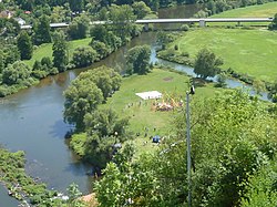
 The Vils flowing into the Naab | |
| Location | |
| Country | Germany |
| State | Bavaria |
| Physical characteristics | |
| Source | |
| • location | Upper Palatinate |
| Mouth | |
• location | Naab |
• coordinates | 49°9′32″N 11°57′19″E |
| Length | 87.4 km (54.3 mi) [1] |
| Basin size | 1,239 km2 (478 sq mi) [1] |
| Basin features | |
| Progression | Naab→ Danube→ Black Sea |
Its source is near Freihung. It is approx. 87 km (54 mi) long. It flows generally south through the towns Vilseck, Amberg and Schmidmühlen. It is a right tributary of the Naab in Kallmünz.
See also
References
- Complete table of the Bavarian Waterbody Register by the Bavarian State Office for the Environment (xls, 10.3 MB)
На других языках
[de] Vils (Naab)
Die Vils ist ein etwa 87 km langer rechter Zufluss der Naab in der Oberpfalz, der im Markt Kallmünz im Landkreis Regensburg nach ungefähr südlichem Lauf in die untere Naab mündet.- [en] Vils (Naab)
[ru] Фильс (приток Наба)
Фильс (нем. Vils) — река в Германии, протекает по земле Бавария, правый приток Наба. Речной индекс 148[1].Текст в блоке "Читать" взят с сайта "Википедия" и доступен по лицензии Creative Commons Attribution-ShareAlike; в отдельных случаях могут действовать дополнительные условия.
Другой контент может иметь иную лицензию. Перед использованием материалов сайта WikiSort.org внимательно изучите правила лицензирования конкретных элементов наполнения сайта.
Другой контент может иметь иную лицензию. Перед использованием материалов сайта WikiSort.org внимательно изучите правила лицензирования конкретных элементов наполнения сайта.
2019-2025
WikiSort.org - проект по пересортировке и дополнению контента Википедии
WikiSort.org - проект по пересортировке и дополнению контента Википедии