geo.wikisort.org - River
Vaupés River (Uaupés River) is a tributary of the Rio Negro in South America. It rises in the Guaviare Department of Colombia, flowing east through Guaviare and Vaupés Departments. It forms part of the international border between the Vaupés department of Colombia and the Amazonas state of Brazil. On the border it merges with the Papurí River and becomes known as the Uaupés. In 1847 an explorer saw a rapid which hurled its waves 12 or 15 metres (40 or 50 ft) in the air, "as if great subaqueous explosions were taking place."[3] The river continues on east through the Alto Rio Negro Indigenous Territory until it flows into the Rio Negro at São Joaquim, Amazonas.[4] Vaupés is a blackwater river.
| Vaupés River Uaupés River | |
|---|---|
 | |
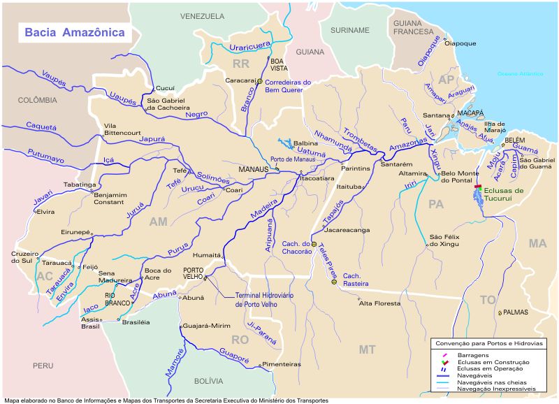 Vaupés (Uaupés) is in the upper left section | |
| Location | |
| Countries |
|
| Physical characteristics | |
| Source | |
| • location | Guaviare Department, Colombia |
| • coordinates | 2°9′1″N 72°57′13″W (approximately) |
| • elevation | 360 m (1,180 ft) |
| Mouth | Rio Negro |
• coordinates | 0°02′3.06″N 67°16′50.16″W |
• elevation | 67 m (220 ft) |
| Length | 1,050 km (650 mi)[1] |
| Basin size | 64,370.4 km2 (24,853.6 sq mi)[2] |
| Discharge | |
| • location | Amazonas, Brazil (near mouth) |
| • average | 4,344.9 m3/s (153,440 cu ft/s)[2] |
| Discharge | |
| • location | Taracuá, Amazonas |
| • average | 2,757.3 m3/s (97,370 cu ft/s)[2] |
| Discharge | |
| • location | Uaracu, Amazonas |
| • average | 2,452.7 m3/s (86,620 cu ft/s)[2] |
| Discharge | |
| • location | Mitú, Vaupés, Colombia |
| • average | 1,232.4 m3/s (43,520 cu ft/s)[2] |
| Basin features | |
| Tributaries | |
| • right | Papuri, Tiquié |
See also
References
- Ziesler, R.; Ardizzone, G.D. (1979). "Amazon River System". The Inland waters of Latin America. Food and Agriculture Organization of the United Nations. ISBN 92-5-000780-9. Archived from the original on 8 November 2014.
- "Rivers Network".
- Discoveries and Explorations, Charles G.D. Roberts, 1905, p.224
- "Terra Indígena Alto Rio Negro", Terras Indígenas no Brasil (in Portuguese), ISA: Instituto Socioambiental, retrieved 2017-03-04
External links
Authority control | |
|---|---|
| General |
|
| National libraries | |
| Other |
|
На других языках
[de] Río Vaupés
Der Río Vaupés (spanisch) oder Rio Uaupés (portugiesisch) ist ein 1.375 km langer, rechter Nebenfluss des Rio Negro im Norden Südamerikas (Kolumbien und nordöstliches Brasilien). Er gehört somit zum Flusssystem des Amazonas.- [en] Vaupés River
[es] Río Vaupés
El río Vaupés (en Brasil y en portugués: rio Uaupés) es un largo río amazónico, uno de los principales afluentes del río Negro, a su vez el afluente más caudaloso del río Amazonas. El río discurre por Colombia —en los departamentos de Guaviare y Vaupés— y por Brasil —en el estado de Amazonas—. Tiene una longitud total de 1050 km.[1][it] Rio Vaupés
Il Rio Vaupés (in portoghese Fiume Uaupes), è un fiume amazzonico ed è affluente del Rio Negro. Il fiume attraversa la Colombia, dipartimento di Guaviare e dipartimento di Vaupés e il Brasile-Amazonas. Ha una lunghezza totale di 1.050 km.Текст в блоке "Читать" взят с сайта "Википедия" и доступен по лицензии Creative Commons Attribution-ShareAlike; в отдельных случаях могут действовать дополнительные условия.
Другой контент может иметь иную лицензию. Перед использованием материалов сайта WikiSort.org внимательно изучите правила лицензирования конкретных элементов наполнения сайта.
Другой контент может иметь иную лицензию. Перед использованием материалов сайта WikiSort.org внимательно изучите правила лицензирования конкретных элементов наполнения сайта.
2019-2026
WikiSort.org - проект по пересортировке и дополнению контента Википедии
WikiSort.org - проект по пересортировке и дополнению контента Википедии