geo.wikisort.org - River
The Vaige (French pronunciation: [vɛʒ]) is a 53.6 km (33.3 mi) long river in the Mayenne and Sarthe departments in western France.[1]
| Vaige | |
|---|---|
 Vaige river at the south of La Bazouge-de-Chemeré in winter | |
  | |
| Location | |
| Country | France |
| Physical characteristics | |
| Source | |
| • location | Saint-Léger |
| • coordinates | 48°04′52″N 00°28′15″W |
| • elevation | 112 m (367 ft) |
| Mouth | |
• location | Sarthe |
• coordinates | 47°50′15″N 00°19′55″W |
• elevation | 24 m (79 ft) |
| Length | 53.6 km (33.3 mi) |
| Basin size | 233 km2 (90 sq mi) |
| Discharge | |
| • average | 1.48 m3/s (52 cu ft/s) |
| Basin features | |
| Progression | Sarthe→ Maine→ Loire→ Atlantic Ocean |
This list is ordered from source to mouth:
- In Mayenne, the Vaige has its source in Saint-Léger then waters the following villages: Vaiges, Saint-Georges-le-Fléchard, La Bazouge-de-Chemeré, La Cropte, Saint-Denis-du-Maine, Préaux, Ballée, Beaumont-Pied-de-Bœuf,
- Then the Vaige séparates Mayenne (Saint-Loup-du-Dorat) from Sarthe (Auvers-le-Hamon),
- Only in Mayenne the Vaige waters Bouessay,
- Entering the Sarthe department, the Vaige avoid the Sablé-sur-Sarthe town and flows in the Sarthe (right tributary)
Low water and flood
Very often the river uses to dry at the end of summer and the beginning of autumn, so fishes and river mussels die but kingfishers may fly away.[citation needed]
 the Vaige dried at the south of the Bazouge-de-Chemeré on September 17, 2005
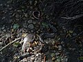 Died fishes in the dried river on 2005
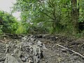 the Vaige dried at the south of the Bazouge-de-Chemeré on June 24, 2017
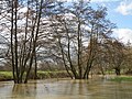 Flood at the south of the Bazouge-de-Chemeré on February 28, 2010
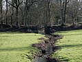 The Chemerette stream passes through an old path before flowing in Vaige river.
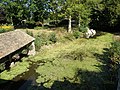 Wash-house in La Cropte


References
This Mayenne geographical article is a stub. You can help Wikipedia by expanding it. |
This Sarthe geographical article is a stub. You can help Wikipedia by expanding it. |
На других языках
[de] Vaige
Die Vaige ist ein Fluss in Frankreich, der in der Region Pays de la Loire verläuft. Sie entspringt im Gemeindegebiet von Saint-Léger, entwässert anfangs in Richtung Süd, schwenkt dann auf Südost und mündet nach rund 54[2] Kilometern bei Sablé-sur-Sarthe als rechter Nebenfluss in die Sarthe. Auf ihrem Weg durchquert die Vaige die Départements Mayenne und Sarthe.- [en] Vaige
Текст в блоке "Читать" взят с сайта "Википедия" и доступен по лицензии Creative Commons Attribution-ShareAlike; в отдельных случаях могут действовать дополнительные условия.
Другой контент может иметь иную лицензию. Перед использованием материалов сайта WikiSort.org внимательно изучите правила лицензирования конкретных элементов наполнения сайта.
Другой контент может иметь иную лицензию. Перед использованием материалов сайта WikiSort.org внимательно изучите правила лицензирования конкретных элементов наполнения сайта.
2019-2026
WikiSort.org - проект по пересортировке и дополнению контента Википедии
WikiSort.org - проект по пересортировке и дополнению контента Википедии