geo.wikisort.org - River
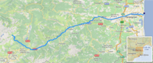
The Têt (French: [tɛt] (![]() listen); Catalan: Tet) is the largest river in Pyrénées-Orientales, southwestern France. It is 115 kilometres (71 mi) long.[1] The Têt has its source at the foot of the Pic Carlit in the Pyrenees. It crosses the Pyrénées-Orientales département (Northern Catalonia) from West to East and ends in the Mediterranean Sea, near Perpignan (Catalan: Perpinyà).
listen); Catalan: Tet) is the largest river in Pyrénées-Orientales, southwestern France. It is 115 kilometres (71 mi) long.[1] The Têt has its source at the foot of the Pic Carlit in the Pyrenees. It crosses the Pyrénées-Orientales département (Northern Catalonia) from West to East and ends in the Mediterranean Sea, near Perpignan (Catalan: Perpinyà).
| Têt | |
|---|---|
 Têt near Villefranche-de-Conflent | |
 | |
| Native name | La Têt (French) |
| Location | |
| Country | France |
| Physical characteristics | |
| Source | |
| • location | Pyrenees |
| • elevation | ±2,400 m (7,900 ft) |
| Mouth | |
• location | Mediterranean Sea |
• coordinates | 42°42′48″N 3°2′23″E |
| Length | 115 km (71 mi) |
| Basin size | 1,550 km2 (600 sq mi) |
| Discharge | |
| • average | 7.5 m3/s (260 cu ft/s) |
Tributaries include
Towns along the river
- Mont-Louis (Mont-Lluis)
- Olette (Oleta)
- Villefranche-de-Conflent (Vilafranca de Conflent)
- Prades (Prada de Conflent)
- Perpignan (Perpinyà)
- Ille-sur-Têt
References
Wikimedia Commons has media related to Têt.
Authority control | |
|---|---|
| General |
|
| National libraries | |
This Pyrénées-Orientales geographical article is a stub. You can help Wikipedia by expanding it. |
На других языках
[de] Têt
Die Têt ist ein Küstenfluss im Süden Frankreichs, der im Département Pyrénées-Orientales in der Region Okzitanien verläuft. Ihr Quellfluss Rec de la Grava entspringt in den Pyrenäen, an der Südwest-Flanke des Gipfels Puig de la Cometa d’Espagna (2763 m), im Gemeindegebiet von Angoustrine-Villeneuve-des-Escaldes. Die Têt entwässert generell Richtung Ost bis Nordost, anfangs durch den Regionalen Naturpark Pyrénées Catalanes, später durch die Roussillon-Ebene, und mündet nach rund 116[2] Kilometern im Gemeindegebiet von Canet-en-Roussillon in das Mittelmeer.- [en] Têt (river)
[es] Río Têt
El río Têt es un río del sur de Francia que discurre por el Rosellón en la Región de Occitania.[it] Têt (fiume)
Il Têt (francese: La Têt, catalano: Tet) è un fiume costiero francese, situato nel dipartimento dei Pirenei Orientali e lungo 120 km.[1] I paesi della valle sulla quale scorre il fiume (chiamata Vallée de la Têt) sono classificati nella lista Villes et Pays d'Art et d'Histoire stilata dal Ministero della Cultura francese.Текст в блоке "Читать" взят с сайта "Википедия" и доступен по лицензии Creative Commons Attribution-ShareAlike; в отдельных случаях могут действовать дополнительные условия.
Другой контент может иметь иную лицензию. Перед использованием материалов сайта WikiSort.org внимательно изучите правила лицензирования конкретных элементов наполнения сайта.
Другой контент может иметь иную лицензию. Перед использованием материалов сайта WikiSort.org внимательно изучите правила лицензирования конкретных элементов наполнения сайта.
2019-2026
WikiSort.org - проект по пересортировке и дополнению контента Википедии
WikiSort.org - проект по пересортировке и дополнению контента Википедии