geo.wikisort.org - River
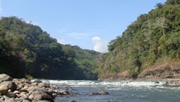
Térraba River (Spanish: Río Grande de Térraba), in the southern Brunca region of Costa Rica, is the largest river in that country.[1]
| Térraba River Río Térraba | |
|---|---|
 Térraba River | |
 Location of mouth | |
| Location | |
| Country | Costa Rica |
| Physical characteristics | |
| Mouth | |
• location | Pacific Ocean |
• coordinates | 9°01′56″N 83°37′36″W |
The indigenous Boruca language name is Diquís which means "great river".[2] Its basin is 5,085 square kilometres (1,963 sq mi) and it is 160 kilometres (99 mi) long, covering ten percent of the country. It is a tributary from the confluence of the Río General and Río Coto Brus.[3] Pineapple plantations occupy 10,815 hectares (26,720 acres) in the basin, amounting to 21 percent of national production.[4] Mangrove cockles (Anadara tuberculosa and Anadara similis), known locally as piangua, are collected in the mangrove swamps and mud at the mouth of the Río Grande de Térraba.[5]
The Interamerican Highway partially follows the river course and crosses it with a bridge. Along the river lie the villages of Palmar Norte, Palmar Sur and Ciudad Cortés. The Térraba empties in the Pacific Ocean with six mouths: Mala, Brava, Chica, Zacate, Guarumal and Sierpe.[3] A nationally protected wetland, Humedal Nacional Térraba-Sierpe (Térraba-Sierpe National Wetlands) is situated here in the mangroves along the coast.[6]
A proposed project to provide renewable energy to the region, El Diquís Hydroelectric Project, was cancelled. It would have covered 7,000 hectares (17,000 acres) and required the relocation of 1,500 people.[7]
References
- Instituto Costarricense de Turismo map Archived 2009-01-26 at the Wayback Machine, 2007. (in Spanish)
- American Cultures > Pre-Columbian Cultures > Intermediate > Diquís > Environment and Geography Museo Chileno de Arte Precolombino. Retrieved: 2012-11-05.
- Río Grande de Térraba Guías Costa Rica. Retrieved: 2012-11-04. (in Spanish)
- Caracterización Socioeconómica de la Cuenca del Río Grande de Térraba Escuela de Relaciones Internacionales, Universidad Nacional Heredia, 2010. (in Spanish)
- The Fisheries for Mangrove Cockles Marine Fisheries Review, 2001.
- "Terraba-Sierpe". Ramsar Sites Information Service. Retrieved 25 April 2018.
- Project Website. Proyecto Hidroelctrico El Diquís Archived 2011-01-28 at the Wayback Machine
External links
| Authority control |
|
|---|
На других языках
[de] Río Térraba
Der Río Térraba (spanisch: Río Grande de Térraba) ist der größte Fluss Costa Ricas.[2] Er durchfließt den Süden des Landes und mündet in den Pazifik.- [en] Térraba River
[es] Río Térraba
El río Grande de Térraba es el río más grande de Costa Rica. También es conocido como río Diquís (del Idioma Brörán de Térraba Dí ques '),[1] que en la lengua boruca significa «agua grande». Paralelamente el nombre Térraba se refiere a la comunidad indígena del mismo nombre que vive en sus orillas.Другой контент может иметь иную лицензию. Перед использованием материалов сайта WikiSort.org внимательно изучите правила лицензирования конкретных элементов наполнения сайта.
WikiSort.org - проект по пересортировке и дополнению контента Википедии