geo.wikisort.org - River
The Thar is a small river of France, in the administrative region Normandie, département de la Manche. It is 24.8 km (15 mi) long,[1] rising to the east of La Haye-Pesnel and emptying into the Bay of Mont Saint-Michel, in the English Channel.
| Thar | |
|---|---|
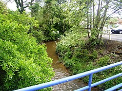
 The Thar at Jullouville | |
| Location | |
| Country | France |
| Physical characteristics | |
| Mouth | English Channel |
• coordinates | 48.8046°N 1.5702°W |
| Length | 24.8 km (15.4 mi) |
In the Middle Ages the Thar formed the traditional boundary between the Cotentin to the north and the Avranchin to the south.
References
На других языках
[de] Thar (Ärmelkanal)
Der Thar ist ein Küstenfluss in Frankreich, der im Département Manche in der Region Normandie verläuft. Er entspringt beim Weiler Noirpalu, an der Gemeindegrenze von La Mouche und Le Tanu, entwässert generell in westlicher Richtung, schlägt knapp vor seiner Mündung noch einen Haken nach Norden und mündet nach rund 25[3] Kilometern knapp südlich von Saint-Pair-sur-Mer im Golf von Saint-Malo in den Ärmelkanal.- [en] Thar (river)
Текст в блоке "Читать" взят с сайта "Википедия" и доступен по лицензии Creative Commons Attribution-ShareAlike; в отдельных случаях могут действовать дополнительные условия.
Другой контент может иметь иную лицензию. Перед использованием материалов сайта WikiSort.org внимательно изучите правила лицензирования конкретных элементов наполнения сайта.
Другой контент может иметь иную лицензию. Перед использованием материалов сайта WikiSort.org внимательно изучите правила лицензирования конкретных элементов наполнения сайта.
2019-2025
WikiSort.org - проект по пересортировке и дополнению контента Википедии
WikiSort.org - проект по пересортировке и дополнению контента Википедии

