geo.wikisort.org - River
The Tempisque River, or Río Tempisque, is 144 kilometres (89 mi) long, located entirely in Costa Rica flowing from the Guanacaste Cordillera near the Orosí Volcano and emptying into the Gulf of Nicoya. It passes through the Palo Verde National Park and is an important habitat for various species of crocodiles, monkeys, iguanas and birds.[1][2]
| Tempisque River | |
|---|---|
 Tempisque River Bridge | |
| Native name | Río Tempisque (Spanish) |
| Location | |
| Country | Costa Rica |
| Province | Guanacaste |
| City | Palo Verde |
| Physical characteristics | |
| Source | Cordillera de Guanacaste |
| • location | Guanacaste, Costa Rica |
| • coordinates | 10°58′48″N 85°28′24″W |
| Mouth | Gulf of Nicoya |
• coordinates | 10°9′20″N 85°13′12″W |
| Length | 144 km (89 mi) |
| Basin size | 611 km2 (236 sq mi) |
The river is heavily silted, limiting navigation to shallow crafts that can cross the muddy flats. Tidal conditions dictate the timing to cross the bar at the river mouth.
Historically the Tempisque was used to float logs down to the sea. The logs were gathered at Chira Island to be loaded on ships.
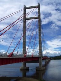
The Tempisque River Bridge was built linking the Nicoya Peninsula to southern Guanacaste and hence significantly cut travel time to San José. It was funded by a gift from the Taiwanese government, and opened in November 2002.
References
- "Tempisque River". Government of Costa Rica. Retrieved June 22, 2021.
- "Rio Tempisque". GeoNames. Retrieved July 24, 2021.
На других языках
[de] Río Tempisque
Der Río Tempisque ist ein 144 km langer, vollständig in der Provinz Guanacaste des Landes Costa Rica verlaufender Fluss. Er entspringt am Orosí ganz im Nordwesten des Landes und fließt in südliche Richtung. Schließlich mündet er in den Golf von Nicoya, einen Teil des Pazifischen Ozeans.- [en] Tempisque River
[es] Río Tempisque
El río Tempisque es un río de Costa Rica que pertenece a la Vertiente del Océano Pacífico. Es el tercer río más extenso del país, después del río Grande de Térraba y el río Reventazón. El Tempisque es el gran río de Guanacaste, que da vida a esta provincia costarricense, pues su cauce recorre gran parte de ese territorio. Nace en la cordillera de Guanacaste, en las faldas del volcán Orosí, con el nombre de río Tempisquito, discurre a lo largo de unos 144 km en dirección sur y sureste por la provincia de Guanacaste, bordeando la península de Nicoya, hasta desembocar en el fondo del golfo de Nicoya, un entrante del océano Pacífico. Antes de verter sus aguas al océano, el río Tempisque drena el área baja y pantanosa que caracteriza al parque nacional Palo Verde. Sus principales afluentes son los ríos Bebedero, Colorado, Liberia y Salto. Es navegable el tramo fluvial comprendido entre su desembocadura y la localidad de Bolsón, por aproximadamente 36 kilómetros. En sus orillas o las de sus afluentes se encuentran importantes ciudades de Guanacaste como Liberia, Santa Cruz y Filadelfia.[ru] Темписке
Темписке (исп. Río Tempisque) — река в Коста-Рике. Берёт начало в Кордильерах провинции Гуанакасте вблизи вулкана Ороси, длина реки примерно 144 километра, впадает в залив Никоя Тихого океана. Протекает через национальный парк Пало-Верде и является важной средой обитания различных видов крокодилов, обезьян, игуан и птиц.Другой контент может иметь иную лицензию. Перед использованием материалов сайта WikiSort.org внимательно изучите правила лицензирования конкретных элементов наполнения сайта.
WikiSort.org - проект по пересортировке и дополнению контента Википедии
