geo.wikisort.org - River
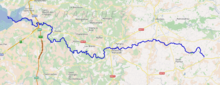
The Sélune is an 85 km long river in the Manche department, Normandy, France,[1] beginning near Saint-Cyr-du-Bailleul. It empties into the bay of Mont Saint-Michel (part of the English Channel) near Avranches, close to the mouth of the Sée river. Other towns along the Sélune are Barenton, Saint-Hilaire-du-Harcouët and Ducey.
| Sélune | |
|---|---|
 The Selune at Ducey | |
 | |
| Location | |
| Country | France |
| Physical characteristics | |
| Source | |
| • location | Normandy |
| Mouth | |
• location | English Channel |
• coordinates | 48°38′51″N 1°23′53″W |
| Length | 85 km (53 mi) |
| Discharge | |
| • average | 11 m3/s |
References
Authority control | |
|---|---|
| General |
|
| Other |
|
This Manche geographical article is a stub. You can help Wikipedia by expanding it. |
На других языках
[de] Sélune
Die Sélune ist ein Fluss in Frankreich, der im Département Manche in der Region Normandie verläuft. Sie entspringt Regionalen Naturpark Normandie-Maine, im Gemeindegebiet von Saint-Cyr-du-Bailleul. Die Sélune entwässert generell in westlicher Richtung und mündet nach rund 85[2] Kilometern nordwestlich von Pontaubault, in der Bucht des Mont-Saint-Michel, in den Ärmelkanal. Im Wattgebiet, das eigentlich nicht mehr zum Flusslauf gezählt wird, vereinigt sie sich noch mit dem Fluss Sée und bildet den Chenal des Fleuves Sée et Sélune, der nur bei Niedrigwasser zu sehen ist.- [en] Sélune
[it] Sélune
La Sélune è un breve fiume della Francia, che scorre nel dipartimento della Manica, nella regione della Bassa Normandia.Текст в блоке "Читать" взят с сайта "Википедия" и доступен по лицензии Creative Commons Attribution-ShareAlike; в отдельных случаях могут действовать дополнительные условия.
Другой контент может иметь иную лицензию. Перед использованием материалов сайта WikiSort.org внимательно изучите правила лицензирования конкретных элементов наполнения сайта.
Другой контент может иметь иную лицензию. Перед использованием материалов сайта WikiSort.org внимательно изучите правила лицензирования конкретных элементов наполнения сайта.
2019-2025
WikiSort.org - проект по пересортировке и дополнению контента Википедии
WikiSort.org - проект по пересортировке и дополнению контента Википедии