geo.wikisort.org - River
The Sweetwater River is a 238-mile (383 km) long tributary of the North Platte River,[2] in the U.S. state of Wyoming. As a part of the Mississippi River system, its waters eventually reach the Gulf of Mexico.
| Sweetwater River | |
|---|---|
 1870 photograph of the Sweetwater River. | |
 North Platte, Sweetwater Rivers across Wyoming | |
| Location | |
| Country | United States |
| State | Wyoming |
| Cities | Sweetwater Station, Jeffrey City |
| Physical characteristics | |
| Source | Sweetwater Gap |
| • location | Wind River Range, Fremont County |
| • coordinates | 42°39′15″N 109°03′25″W[1] |
| • elevation | 10,200 ft (3,100 m) |
| Mouth | North Platte River |
• location | Pathfinder Reservoir, Natrona County |
• coordinates | 42°30′25″N 109°03′25″W[1] |
• elevation | 5,853 ft (1,784 m) |
| Length | 238 mi (383 km)[2] |
| Basin size | 2,880 sq mi (7,500 km2)[3] |
| Discharge | |
| • location | above Pathfinder Reservoir[4] |
| • average | 120.8 cu ft/s (3.42 m3/s)[4] |
| • minimum | 0.5 cu ft/s (0.014 m3/s) |
| • maximum | 4,290 cu ft/s (121 m3/s) |
Course
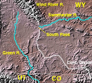
The Sweetwater rises in southwestern Fremont County, at the continental divide near South Pass Wyoming, on the southern end of the Wind River Range. It flows ENE along the north side of the Antelope Hills, then ESE, through Fremont County, past Jeffrey City, between the Granite Mountains to the north and the Green Mountains (Wyoming) to the south, through what are now cattle-raising areas. In southern Natrona County, it passes Devil's Gate and Independence Rock along the Oregon, California and Mormon Trails, and empties into the North Platte as the Sweetwater arm of Pathfinder Reservoir.
History
The Sweetwater River valley provided a route used by fur trappers, mountain men and fur traders as they went to their annual summertime Rocky Mountain Rendezvous located usually somewhere along the Green River Wyoming. These trappers and traders soon established a path for their pack trains along the Sweetwater and eventually cleared a rough wagon trail to the Green River.
In fall of 1823, trappers and fur traders Jedediah Smith and Thomas Fitzpatrick led their trapping crew south from the Yellowstone River to the Sweetwater River. They were looking for a safe location to spend the winter. Smith reasoned since the Sweetwater flowed east it must eventually run into the Missouri River. Trying to transport their extensive fur collection down the Sweetwater and North Platte River, they found after a near disastrous canoe crash that the rivers in Wyoming were too swift and rough for water passage. On July 4, 1824, they cached their furs under a dome of rock they named Independence Rock and started their long trek on foot to the Missouri River via the Sweetwater, North Platte and Platte River valleys. Upon arriving back in a settled area on the Missouri River they bought pack horses (on credit) and retrieved their furs. They had re-discovered the route that Robert Stuart of the Astor Expedition had taken in 1813—eleven years before. Thomas Fitzpatrick was often hired as a trail guide when the fur trade almost ceased in 1840. Jedediah Smith was killed by Indians about 1831.
By 1843 the Sweetwater River valley was a regular wagon trail providing the water, grass and fuel needed on the Oregon, California and Mormon Trails across Wyoming. The Sweetwater provided an almost direct path from the Platte and North Platte Rivers to the wide South Pass Continental Divide between the Atlantic Ocean rivers and Pacific Ocean rivers. South Pass was the easiest pass across the Atlantic and Pacific drainages. These wagon trails crossed the meandering Sweetwater River about nine times on their about 10 to 20 day trips along the Sweetwater River before they reached South Pass. The Sweetwater River's connection to the California Trail is of particular interest to members of the Fraternity of Phi Gamma Delta, since it is a site where two early members met, including one of the fraternity's six founders. At a time when such a meeting was incredibly unlikely, the coincidence was so fortuitous as to be chronicled in the fraternity's history.[5]
See also
References
- "Sweetwater River". Geographic Names Information System. United States Geological Survey. 1979-06-05. Retrieved 2015-12-10.
- U.S. Geological Survey. National Hydrography Dataset high-resolution flowline data. The National Map, accessed March 21, 2011
- "Boundary Descriptions and Names of Regions, Subregions, Accounting Units and Cataloging Units". United States Geological Survey. Retrieved 2015-12-10.
- "USGS Gage #06639000 on the Sweetwater River near Alcova, WY" (PDF). National Water Information System. U.S. Geological Survey. 1913–2013. Retrieved 2015-12-09.
- "Phi Gamma Delta".
На других языках
[de] Sweetwater River (North Platte River)
Der Sweetwater River ist ein Fluss im US-Bundesstaat Wyoming. Er entspringt an der kontinentalen Wasserscheide im Süden der Wind River Range, einer Gebirgskette der Rocky Mountains, und mündet nach knapp 250 km (150 Meilen) in den North Platte River, beziehungsweise in das Pathfinder Reservoir, zu dem die beiden Flüsse durch den Kortes Damm aufgestaut werden.- [en] Sweetwater River (Wyoming)
[es] Río Sweetwater
El río Sweetwater (en inglés, Sweetwater River; que en español significa, «río de aguas dulces») es un corto río del Medio Oeste de los Estados Unidos, uno de los principales afluentes del río Platte Norte, que discurre por la parte central de la vertiente oriental de las Montañas Rocosas. Tiene una longitud aproximada de unos 282 km.[1][it] Sweetwater (Wyoming)
Il fiume Sweetwater è un fiume degli Stati Uniti d'America, tributario del fiume North Platte, lungo approssimativamente 238 miglia (383 km),[1] nello Stato del Wyoming. Ha la sua sorgente nella Contea di Fremont sudoccidentale, presso il Continental Divide vicino al South Pass, all'estremità meridionale della Wind River Range. Scorre a est-nord-est lungo il lato settentrionale delle Antelope Hills, quindi est-sud-est, attraverso la Contea di Fremont, oltre Jeffrey City, tra le Granite Mountains a nord e le Green Mountains a sud, attraverso zone di allevamento di bestiame. Nella Contea di Natrona meridionale, passa attraverso il Devil's Gate e l'Independence Rock, e si versa nel North Platte, come il braccio Sweetwater del lago artificiale denominato Pathfinder Reservoir.[ru] Суитуотер (приток Норт-Платта)
Суитуотер (англ. Sweetwater River) — река в штате Вайоминг, США. Левый приток реки Норт-Платт, которая является одной из двух составляющих реки Платт. Составляет 383 км в длину[2]. Берёт начало в округе Фримонт, на южной оконечности горного хребта Уинд-Ривер. Протекает через город Джеффри-Сити. Течёт преимущественно в восточном и северо-восточном направлениях, протекая между хребтами Гранит-Маунтинс (на севере) и Грин-Маунтинс (на юге). Впадает в реку Норт-Платт в месте водохранилища Пасфайндер.Другой контент может иметь иную лицензию. Перед использованием материалов сайта WikiSort.org внимательно изучите правила лицензирования конкретных элементов наполнения сайта.
WikiSort.org - проект по пересортировке и дополнению контента Википедии