geo.wikisort.org - River
The St. Francis River is a tributary of the Mississippi River, about 426 miles (686 km) long,[4] in southeastern Missouri and northeastern Arkansas in the United States. The river drains a mostly rural area and forms part of the Missouri-Arkansas state line along the western side of the Missouri Bootheel.
| St. Francis River | |
|---|---|
 The St. Francis River at Lake City, Arkansas is placid and silt-laden. | |
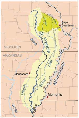 Map of the St. Francis River watershed. The Castor/Whitewater headwaters (darker shade on the map) were historically part of the St. Francis watershed but are now diverted to the Mississippi. | |
| Location | |
| Country | United States |
| State | Missouri, Arkansas |
| Region | Ozark Plateau, Mississippi Alluvial Plain |
| District | St. Francois Mountains, Crowleys Ridge |
| Cities | Farmington, Missouri, Fisk, Missouri, Lake City, Arkansas, Marked Tree, Arkansas |
| Physical characteristics | |
| Source | Elephant Rocks State Park |
| • location | Iron County, St. Francois Mountains, Ozark Plateau, Missouri |
| • elevation | 1,568 ft (478 m) |
| Mouth | Mississippi River |
• location | Near Helena-West Helena, Phillips County, Mississippi Alluvial Plain, Arkansas |
• coordinates | 34°37′28″N 90°35′31″W[1] |
• elevation | 171 ft (52 m)[1] |
| Length | 426 mi (686 km) |
| Basin size | 7,550 sq mi (19,600 km2)[2] |
| Discharge | |
| • location | Latitude of Wittsburg |
| • average | 8,976 cu ft/s (254.2 m3/s)[3] |
| Basin features | |
| Tributaries | |
| • left | Little St. Francis River, 12-Mile Creek, Blue Spring, Mingo Ditch, Little River |
| • right | Stouts Creek, Marble Creek, Big Creek, Otter Creek, L'Anguille River |
Description and course
The river rises in a region of granite mountains in Iron County, Missouri, and flows generally southwardly through the Ozarks and the St. Francois Mountains near Missouri's highest point Taum Sauk. It forms the Missouri-Arkansas border in the Bootheel and eventually exits the state at Missouri's lowest point in the "toe" at 241 feet (73 m) above sea level. It passes through Lake Wappapello, which is formed by a dam constructed in 1941. Below the dam the river meanders through cane forests and willow wetlands or forested swamp, transitioning from a clear stream into a slow and silt-laden muddy river as it enters the flat lands of the Mississippi embayment. In its lower course the river parallels Crowleys Ridge and is part of a navigation and flood-control project that encompasses a network of diversion channels and ditches along it and the Castor and Little rivers. Below the mouth of the Little River in Poinsett County, Arkansas, the St. Francis is navigable by barge. It joins the Mississippi River in Phillips County, Arkansas, about 7 miles (11 km) north of Helena.
Along its course in Missouri, the river flows through the Mark Twain National Forest and past Sam A. Baker State Park and the towns of Farmington, Greenville and Fisk. In Arkansas it passes the towns of St. Francis, Lake City, Marked Tree and Parkin, and continues through two additional namesakes of the river — St. Francis County, and St. Francis Township in northeastern Phillips County — ending its course adjoining the St. Francis National Forest.
In addition to the Little River, tributaries of the St. Francis include the Little St. Francis River, which joins it along its upper course in Missouri; the Tyronza River, which joins it in Arkansas; and the L'Anguille River, which joins it just above its mouth.
History
The river became the home of Cherokee Indians who attacked a boat on the Tennessee River on June 11, 1794 known as the Muscle Shoals Massacre and had removed to the west.[5] The Spanish authorities allowed the Indian settlement to trade and the area flourished with a population greater than Arkansas Post.
Names
The origin of the river's name is unclear. It might refer to St. Francis of Assisi, the founder of the Franciscan order. None of the region's early explorers were Franciscans, however. One possibility is that Jacques Marquette, a Jesuit, named the river when he explored its mouth in 1673. Before his voyage down the Mississippi Marquette had spent some time at the mission of St. Francois Xavier, named for the Jesuit missionary Francis Xavier. The spelling of the river's name shifted from "François" to "Francis" in the early 20th century. A number of place names in the region stem from the river's name, including St. Francois County and the St. Francois Mountains.[6]
The United States Board on Geographic Names settled on "St. Francis River" as the stream's name in 1899. According to the Geographic Names Information System, historical names for the river have included:
|
|
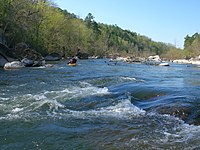 The St. Francis River rises in the granite mountains of the eastern Ozarks where it is a clear, rapid stream.
 Silver Mine Dam on the upper St. Francis River


See also
- List of Arkansas rivers
- List of Missouri rivers
- River borders of U.S. states
References
- U.S. Geological Survey Geographic Names Information System: St. Francis River
- Senator Pryor Announces Arkansas Projects in Water Resources Development Bill Archived 2009-08-13 at the Wayback Machine, Senator Mark Pryor Press Releases
- "USGS Surface Water data for Arkansas: USGS Surface-Water Annual Statistics".
- U.S. Geological Survey. National Hydrography Dataset high-resolution flowline data. The National Map, accessed March 9, 2011
- Myers, Robert A. “Cherokee Pioneers in Arkansas: The St. Francis Years, 1785-1813.” The Arkansas Historical Quarterly, vol. 56, no. 2, 1997, pp. 127–157. JSTOR website Retrieved 18 July 2021.
- St. Francois County, Missouri Place Names Archived 2011-07-20 at the Wayback Machine, Western Historical Manuscript Collection
External links
- Columbia Gazetteer of North America entry
- DeLorme (2004). Arkansas Atlas & Gazetteer. Yarmouth, Maine: DeLorme. ISBN 0-89933-345-1.
- DeLorme (2002). Missouri Atlas & Gazetteer. Yarmouth, Maine: DeLorme. ISBN 0-89933-353-2.
- U.S. Geological Survey Geographic Names Information System: St. Francis River
- Maps of Former St. Francis Lake in Northeast Arkansas
Authority control | |
|---|---|
| National libraries | |
| Other | |
На других языках
[de] Saint Francis River (Mississippi River)
Der Saint Francis River ist ein 686 km langer rechter Nebenfluss des Mississippi Rivers im Südosten von Missouri und dem Nordosten von Arkansas in den Vereinigten Staaten.- [en] St. Francis River
[es] Río Saint Francis
El río Saint Francis o río San Francisco[1] (en inglés: St. Francis River), es un largo afluente por la ribera derecha del río Misisipi, un río que discurre por del suroeste del estado de Misuri y el este del estado de Arkansas, en los Estados Unidos. Se origina en el sudeste de Misuri y fluye hacia el sur, desembocando en el Misisipí justo encima de la ciudad de Helena, después de haber recorrido 684 km. Parte de su curso forma durante un tramo la frontera entre los estados de Misuri y Arkansas. Es navegable unos 201 km.[it] Saint Francis
Il Saint Francis è un fiume degli Stati Uniti d'America centrali, situato tra il Missouri sudorientale e l'Arkansas nordorientale lungo circa 760 km, affluente del Mississippi. Il fiume attraversa una zona principalmente rurale e forma parte del confine tra i due stati.[ru] Сент-Франсис (приток Миссисипи)
Сент-Франсис[1] (англ. Saint Francis River) — река в США, приток Миссисипи. Длина — 720 км, площадь бассейна 22 600 км²[2]. Среднегодовой расход воды — 167 м³/сек[2].Другой контент может иметь иную лицензию. Перед использованием материалов сайта WikiSort.org внимательно изучите правила лицензирования конкретных элементов наполнения сайта.
WikiSort.org - проект по пересортировке и дополнению контента Википедии