geo.wikisort.org - River
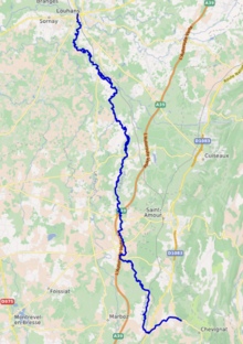
The Solnan (French pronunciation: [sɔlnɑ̃]) is a 61.6-kilometre (38.3 mi) long river in the Ain and Saône-et-Loire departments in eastern France.[1] Its source is at Verjon, in the Jura Mountains. It flows generally north-northwest. It is a left tributary of the Seille into which it flows at Louhans.
| Solnan | |
|---|---|
 | |
 | |
| Location | |
| Country | France |
| Physical characteristics | |
| Source | |
| • location | Verjon |
| • coordinates | 46°20′33″N 05°21′34″E |
| • elevation | 235 m (771 ft) |
| Mouth | |
• location | Seille |
• coordinates | 46°37′45″N 05°13′05″E |
• elevation | 177 m (581 ft) |
| Length | 61.6 km (38.3 mi) |
| Basin size | 680 km2 (260 sq mi) |
| Discharge | |
| • average | 13 m3/s (460 cu ft/s) |
| Basin features | |
| Progression | Seille→ Saône→ Rhône→ Mediterranean Sea |
Its main tributaries are the Sevron and the Vallière.
Departments and communes along its course
This list is ordered from source to mouth:
- Ain: Verjon, Villemotier, Bény, Salavre, Coligny, Pirajoux, Domsure, Beaupont,
- Saône-et-Loire: Condal, Dommartin-lès-Cuiseaux, Varennes-Saint-Sauveur, Frontenaud, Sainte-Croix, Bruailles, La Chapelle-Naude, Louhans,
References
This Ain geographical article is a stub. You can help Wikipedia by expanding it. |
This Saône-et-Loire geographical article is a stub. You can help Wikipedia by expanding it. |
На других языках
[de] Solnan
Der Solnan ist ein Fluss in Frankreich, der in den Regionen Auvergne-Rhône-Alpes und Bourgogne-Franche-Comté verläuft. Er entspringt im Jura, im Gemeindegebiet von Verjon, entwässert anfangs Richtung Südwest, schlägt dann einen großen Bogen um den Ort Villemotier, verläuft ab dort nordwärts und mündet nach insgesamt rund 62[2] Kilometern im Stadtgebiet von Louhans als linker Nebenfluss in die Seille. Auf seinem Weg durchquert der Solnan die Départements Ain und Saône-et-Loire.- [en] Solnan
[it] Solnan
Il Solnan è un fiume lungo 61,6 km che scorre nei dipartimenti dell'Ain e della Saona e Loira, nell'est della Francia. Nasce nel Verjon, un monte del Massiccio del Giura.Текст в блоке "Читать" взят с сайта "Википедия" и доступен по лицензии Creative Commons Attribution-ShareAlike; в отдельных случаях могут действовать дополнительные условия.
Другой контент может иметь иную лицензию. Перед использованием материалов сайта WikiSort.org внимательно изучите правила лицензирования конкретных элементов наполнения сайта.
Другой контент может иметь иную лицензию. Перед использованием материалов сайта WikiSort.org внимательно изучите правила лицензирования конкретных элементов наполнения сайта.
2019-2026
WikiSort.org - проект по пересортировке и дополнению контента Википедии
WikiSort.org - проект по пересортировке и дополнению контента Википедии