geo.wikisort.org - River
The Snohomish River is a river in Snohomish County, Washington, formed by the confluence of the Skykomish and Snoqualmie rivers near Monroe. It flows northwest entering Port Gardner Bay, part of Puget Sound, between Everett and Marysville. The Pilchuck River is its main tributary and joins the river at Snohomish. The river system drains the west side of the Cascade Mountains from Snoqualmie Pass to north of Stevens Pass.
| Snohomish River | |
|---|---|
 Snohomish River at Snohomish | |
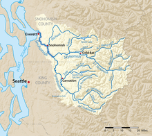 Map of the Snohomish River and tributaries | |
 Mouth of the Snohomish River in Washington  Snohomish River (the United States) | |
| Location | |
| Country | United States |
| State | Washington |
| County | Snohomish |
| Physical characteristics | |
| Source | Confluence of the Skykomish River and the Snoqualmie River |
| • location | Monroe |
| • coordinates | 47°49′48″N 122°2′47″W[1] |
| Mouth | Puget Sound |
• location | Port Gardner |
• coordinates | 48°1′16″N 122°12′30″W[1] |
• elevation | 0 m (0 ft) |
| Length | 20 mi (32 km)[2] |
| Basin size | 1,856 sq mi (4,810 km2)[3] |
| Discharge | |
| • location | Near Monroe[4] |
| • average | 9,511 cu ft/s (269.3 m3/s)[4] |
| • minimum | 763 cu ft/s (21.6 m3/s) |
| • maximum | 150,000 cu ft/s (4,200 m3/s) |
Measured at Monroe, the Snohomish River has an average annual flow of 9,500 cubic feet per second (270 m3/s).[2] In comparison, the Columbia River, Washington's largest river, has an average flow of about 265,000 cubic feet per second (7,500 m3/s).[5]


Course
The Snohomish River forms at the confluence of the Snoqualmie and Skykomish Rivers just west of Monroe. Both of these rivers originate in the Cascades and drain the west slopes of the mountains in southeastern Snohomish County and northeastern King County. The Snohomish River flows generally northwestward from the confluence, passing under state route 522 and flowing alongside Lord Hill Regional Park before reaching downtown Snohomish. Here, it is joined by the Pilchuck River, its main tributary, and flows under state route 9. From Snohomish, the river continues northwestward through a broad floodplain, forming the eastern boundary of the city of Everett. The final few miles of the river in Everett form the Snohomish River estuary, a river delta that features wetlands and tideflats spread out across various islands and arms of the river.[6] Several bridges carry U.S. 2, Interstate 5, and state route 529 across the delta. The river then empties into Possession Sound, which is part of Puget Sound, between Everett and Marysville.

See also
- List of rivers of Washington
References
- U.S. Geological Survey Geographic Names Information System: Snohomish River
- Snohomish River Watershed Draft Initial Assessment Archived 2006-10-04 at the Wayback Machine
- Surface Water Management Division: Snohomish River Salmon Recovery
- USGS Snohomish River gauge near Monroe
- Kammerer, J.C. (May 1990). "Largest Rivers in the United States". U.S. Geological Survey. Retrieved 2008-04-01.
- Brennick, Charles. "Snohomish River Estuary Recreation Guide". Snohomish County Estuary. Snohomish County government. Retrieved 11 July 2019.
External links
 Media related to Snohomish River at Wikimedia Commons
| Authority control |
|---|
This Snohomish County, Washington state location article is a stub. You can help Wikipedia by expanding it. |
На других языках
[de] Snohomish River
Der Snohomish River ist ein Fluss im US-Bundesstaat Washington, welcher seinen Namen beim Zusammenfluss des Skykomish River und des Snoqualmie River in der Nähe Monroes erhält. Er fließt nordwestlicher Richtung, bis er zwischen Everett und Marysville in die Port Gardner Bay, Teil des Puget Sound, fließt. Der Pilchuck River ist sein größter Nebenfluss und mündet bei Snohomish in ihn ein. Der Snohomish River entwässert die Westseite der Kaskadenkette vom Snoqualmie Pass bis zum nördlich gelegenen Stevens Pass.- [en] Snohomish River
[ru] Снохомиш (река)
Снохомиш (англ. Snohomish River) — река на северо-западе центральной части штата Вашингтон, США. Образуется при слиянии рек Скайкомиш и Сноукуони близ города Монро. Течёт преимущественно в северо-западном направлении и впадает в залив Порт-Гарднер (часть залива Пьюджет) близ города Эверетт. Крупнейший приток — Пилчак, текущий с севера и впадающий в реку в городе Снохомиш. Бассейн реки включает западные склоны Каскадных гор от перевала Сноукуони до местности севернее перевала Стивенс.Другой контент может иметь иную лицензию. Перед использованием материалов сайта WikiSort.org внимательно изучите правила лицензирования конкретных элементов наполнения сайта.
WikiSort.org - проект по пересортировке и дополнению контента Википедии