geo.wikisort.org - River
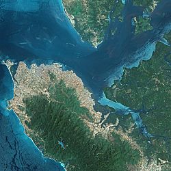
The Sierra Leone River is a river estuary on the Atlantic Ocean in Western Sierra Leone. It is formed by the Bankasoka River and Rokel River and is between 4 and 10 miles wide (6–16 km) and 25 miles (40 km) long. It holds the major ports of Queen Elizabeth II Quay and Pepel. The estuary is also important for shipping. It is the largest natural harbour in the African continent. Several islands, including Tasso Island (the largest), Tombo Island, and the historically important Bunce Island, are located in the estuary.[2]
| Sierra Leone River | |
|---|---|
 Sierra Leone River Estuary | |
| Physical characteristics | |
| Mouth | |
• location | Atlantic Ocean |
• coordinates | 8.504°N 13.186°W |
| Length | 25 mi (40 km) |
Ramsar Wetland | |
| Official name | Sierra Leone River Estuary |
| Designated | 13 December 1999 |
| Reference no. | 1014[1] |
Lungi International Airport
The river separates Freetown, Sierra Leone's capital city, which is on the south side of the harbor, from the country's principal airport, Lungi International Airport, which is on the north side of the harbor in an area called the "Bullom Shore." The primary means of transportation from the airport to Freetown are by speed boat or ferry. Hovercraft, or helicopter services are no longer running.
Ecology
The 2,950 square kilometres (1,140 sq mi) of the Sierra Leone River estuary is classified as a wetland of international importance Ramsar Convention in the west of Sierra Leone.[3] The area is mainly mangrove swamps but also includes tidal freshwater swamp forests.[4]
References
- "Sierra Leone River Estuary". Ramsar Sites Information Service. Retrieved 25 April 2018.
- "Sierra Leone River" britannica.com
- World Database on Protected Areas: Site Information Archived 2008-09-24 at the Wayback Machine, UN Environment Programme World Conservation Monitoring Centre (2004), retrieved on 10 November 2007
- Ramsar Sites Information Service Archived 2008-07-14 at the Wayback Machine, Ramsar, retrieved on 10 November 2007
See also
- Protected areas of Sierra Leone
- Ramsar list of wetlands of international importance
На других языках
[de] Sierra Leone River
Der Sierra Leone River ist ein Fluss beziehungsweise Ästuar in Sierra Leone.- [en] Sierra Leone River
[ru] Сьерра-Леоне (река)
Сьерра-Леоне (англ. Sierra Leone River) — река с эстуарием в Атлантическом океане на западе одноимённой страны. Он образован реками Банкасока[en] и Рокель[en] и имеет ширину от 6 до 16 км и 40 км в длину. Близ реки находятся крупнейшие порты: Набережная Елизаветы Второй[en] и Пепель[en]. Река также важна для судоходства. Это самая большая естественная гавань на африканском континенте. В эстуарии находятся несколько островов, такие как Тассо[de] (крупнейший среди всех), Томбо[en] и Банс[en] (имеющий историческое значение — на острове находится замок, построенный английскими работорговцами)[1].Другой контент может иметь иную лицензию. Перед использованием материалов сайта WikiSort.org внимательно изучите правила лицензирования конкретных элементов наполнения сайта.
WikiSort.org - проект по пересортировке и дополнению контента Википедии