geo.wikisort.org - River
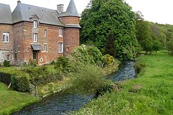
The Saâne (French pronunciation: [san]) is a river of Normandy, France, 40 kilometres (25 mi) in length,[1] flowing through the department of Seine-Maritime.
| Saâne | |
|---|---|
 The Saâne river (Biville-la-Rivière) | |
| Native name | La Saâne (French) |
| Location | |
| Country | France |
| Physical characteristics | |
| Source | |
| • location | Val-de-Saâne |
| • elevation | 158 m (518 ft) |
| Mouth | |
• location | English Channel |
• coordinates | 49°53′N 0°55′E |
| Length | 40.1 km (24.9 mi) |
| Basin size | 270 km2 (100 sq mi) |
| Discharge | |
| • average | 2.6 m3/s (92 cu ft/s) |
Geography
The Saâne has its source in the Pays de Caux in the territory of the hamlet of Varvannes, in the commune of Val-de-Saâne. Taking a northward journey, it flows through the communes of Saâne-Saint-Just, Auzouville-sur-Saâne, Biville-la-Rivière, Brachy, Gueures, Ouville-la-Rivière and Longueil and meets the English Channel between Quiberville and Sainte-Marguerite-sur-Mer. At Longueil, not far from the mouth, the flow is relatively low, at 2.6 m/s, because of the small size of the watershed (270 km),[2] however, at Gueures, on the right bank, a significant tributary, the Vienne river, 15 km in length, joins with the Saane. Like most other rivers in the region, the Saâne is classified as a first class river, offering anglers the chance to catch trout and salmon.[3]
See also
- French water management scheme
Bibliography
- Albert Hennetier, Aux sources normandes: Promenade au fil des rivières en Seine-Maritime, Ed. Bertout, Luneray, 2006 ISBN 2867436230
References
- Sandre. "Fiche cours d'eau - Saâne (G4--0200)".
- Station hydrologique de Longueil. Données hydrologiques, code de la station : G4202010. Consulted 11 June 2008.
- The Saane The Saane on the Natura 2000 website.
На других языках
[de] Saâne
Die Saâne (manchmal auch Saane geschrieben) ist ein Küstenfluss in Frankreich, der im Département Seine-Maritime in der Region Normandie verläuft. Sie entspringt am östlichen Ortsrand von Yerville, entwässert im Oberlauf in östlicher Richtung, schwenkt dann nach Norden, durchquert die Naturlandschaft Pays de Caux und mündet nach rund 40[3] Kilometern an der Gemeindegrenze von Sainte-Marguerite-sur-Mer und Quiberville in den Ärmelkanal.- [en] Saâne
Другой контент может иметь иную лицензию. Перед использованием материалов сайта WikiSort.org внимательно изучите правила лицензирования конкретных элементов наполнения сайта.
WikiSort.org - проект по пересортировке и дополнению контента Википедии

