geo.wikisort.org - River
Río Negro (Spanish pronunciation: [ˈri.o ˈneɣɾo]; Black River) is the most important river of the Argentine province of Río Negro, and Patagonia in relation to its flow rate. Its name comes from the literal translation of the Mapuche term Curu Leuvu, although the water is more green than black. Formerly, it was also known as "river of the willows" because of the big number of weeping willows that grow along the bank. It is 635 km in length.
| Negro Curú Leuvú, Río de los Sauces | |
|---|---|
 Rio Negro near the mouth, seen from its northern bank, between the cities of Viedma, Río Negro and Carmen de Patagones, Buenos Aires | |
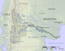 Map of the Río Negro drainage basin | |
| Location | |
| Country | Argentina |
| Provinces | |
| Region | Patagonia |
| Cities |
|
| Physical characteristics | |
| Source | Limay River |
| • location | Nahuel Huapi Lake, Neuquén |
| • coordinates | 41°03′20″S 71°09′07″W |
| • elevation | 770 m (2,530 ft) |
| 2nd source | Neuquén River |
| • location | Near Laguna Fea, Neuquén |
| • coordinates | 36°10′53″S 70°34′16″W |
| • elevation | 2,800 m (9,200 ft) |
| Source confluence | |
| • location | Neuquén, Río Negro |
| • coordinates | 38°59′40″S 68°00′07″W |
| • elevation | 250 m (820 ft) |
| Mouth | Atlantic Ocean |
• location | El Cóndor, Río Negro |
• coordinates | 41°01′50″S 62°47′23″W |
• elevation | 0 m (0 ft) |
| Length | 550 km (340 mi) |
| Basin size | 102,000 km2 (39,000 sq mi) |
| Discharge | |
| • location | Primera Angostura |
| • average | 762.5 m3/s (26,930 cu ft/s) |
| • minimum | 181 m3/s (6,400 cu ft/s) |
| • maximum | 2,068 m3/s (73,000 cu ft/s) |
| Basin features | |
| Tributaries | |
| • left | Neuquén River |
| • right | Limay River |
It originates from the junction of the Limay River and Neuquén River at the border with the Neuquén Province, and flows southeast to the Atlantic Ocean at 41.0223°S 62.7903°W, near El Cóndor beach resort some 30 km (19 mi) downstream from Viedma, Río Negro province's capital.
The river allows the Río Negro province to produce 65% of the pears and apples of Argentina. Besides irrigation, the river is also source of hydroelectricity with small dams on its course.
The river served as natural demarcation between "civilization" and the aboriginal territories during the Conquest of the Desert of late 19th century.
Valleys

The river is divided into three parts: The Alto Valle (High Valley) near the beginning of the river, Valle Medio (Medium Valley) near Choele Choel, and Valle Inferior (Lower Valley) near its end.
The river crosses the steppe plains of the province through a forest of around 3 km (1.9 mi) in the Alto Valle, and as wide as 20 km (12 mi) towards the Valle Inferior. In the dry plain it is possible to find seashells and pebble.
Alto Valle
The main cities in Alto Valle are: General Roca, Cipolletti, Cinco Saltos, followed by many others on the National Route #22. Together with San Carlos de Bariloche, this is the most prosperous part of the province. Most pear and apple plantations are at the Alto Valle, but many also at the Valle Medio.
Valle Medio
Next to Choele Choel is the Choele Choel Island, in which are Lamarque, Luis Beltrán and Pomona, all of them on National Route #250.
Besides apple and pear cultivation, tomato is also an important crop, being Lamarque the National Capital of the Tomato. Outside the valley, on the more arid lands around town such as Chimpay and Darwin, some cattle is also raised.
Valle Inferior
Although the term is not as used term as the previous two, Valle Inferior refers to Viedma and all the cities on the province's coast. Fruit is also produced but is not a primary activity. Onion is cultivated as well as some cereals. Alfalfa and maize is cultivated both for human consumption and for feeding cattle, which is the most important activity.
Name
In spite of its name of Negro ("black") the colour is more greenish than black. Nevertheless, the name is the literal translation of its aboriginal Mapuche name of Curú Leuvú. The river was also known by the name of Río de los Sauces ("River of Willows") for the abundant weeping willows along its lower course.
Regatta
The Regata del Río Negro (Black River Regatta), run in this river, is the longest kayak boat-race in the world with its 653 km (406 mi). The competition is divided in six stages and last 8 days (with two days for resting).
The categories are
- K1 men Senior
- K2 men Senior
- K2 men Junior (17 to 20 years)
- K2 women Senior
- K1 men Maxi (older than 36)
- K2 men Maxi
- Touring (open, non professional recreative category)
References
- Colbert E. Cushing, Kenneth W. Cummins, G. Wayne Minshall: River and Stream Ecosystems of the World: With a New Introduction. University of California Press 2006, ISBN 0-520-24567-9, S. 280ff (restricted online version (Google Books))
External links
- Upper Valley (English)
- Valle Medio (Spanish)
- El Valle (Spanish)
- Regatta's official site (English & Spanish)
| Authority control: National libraries |
|---|
На других языках
[de] Río Negro (Atlantischer Ozean)
Der Rio Negro ist ein etwa 637 Kilometer langer Fluss in Argentinien.- [en] Río Negro (Argentina)
[es] Río Negro (Argentina)
El río Negro es el curso de agua más importante de la provincia argentina de Río Negro y también de la Patagonia en cuanto a su caudal. Su nombre proviene de la traducción literal del mapundungún Curú Leufvú, a pesar de que sus aguas son de un color más verde oscuro que negro.[1] Antiguamente era conocido también como río de los Sauces debido a la gran cantidad de sauces llorones que hay en sus orillas. Tiene una longitud de 635 km, aunque con una de sus cabeceras, el río Limay, la longitud total del sistema fluvial Negro-Limay llega hasta los 1252 km.[2][it] Río Negro (fiume Argentina)
Il Río Negro è il più importante fiume della provincia argentina di Rio Negro. Si snoda su una lunghezza di 635 km e il suo bacino idrografico copre una superficie di 132.275 km².[ru] Рио-Негро (река, впадает в Атлантический океан)
Ри́о-Не́гро (исп. Río Negro — буквально чёрная река) — река в Аргентине, на севере Патагонии. Длина 635 км. Средний расход воды 1014 м³/с. Высота истока — 255 м над уровнем моря.[источник не указан 1913 дней] Образуется слиянием рек Неукен и Лимай, берущих начало на восточных склонах Анд. Впадает в Атлантический океан вблизи курорта Эль-Кондор, примерно в 30 км ниже по течению от городов Вьедма и Кармен-де-Патагонес. Площадь бассейна около 130 тыс. км².Другой контент может иметь иную лицензию. Перед использованием материалов сайта WikiSort.org внимательно изучите правила лицензирования конкретных элементов наполнения сайта.
WikiSort.org - проект по пересортировке и дополнению контента Википедии