geo.wikisort.org - River
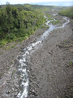
The Rivière de l'Est is a river on the Indian Ocean island of Réunion. It flows northeast from the southeast of the island, reaching the sea between the towns of Sainte-Anne and Sainte-Rose. It is 21.2 km (13.2 mi) long.[1]
| Rivière de l'Est | |
|---|---|
 View from the bridge across Le Rivière de l'Est | |
| Location | |
| Country | France |
| Region | Réunion |
| Physical characteristics | |
| Source | |
| • elevation | 2,350 ft (720 m) |
| Mouth | |
• location | Indian Ocean |
• coordinates | 21°6′22″S 55°46′13″E |
• elevation | sea level |
| Length | 21.2 km (13.2 mi) |
The Rivière de l'Est flows down the slopes of the Shield volcano Piton de la Fournaise from an elevation of 720 metres (2,350 ft) above sea level.
References
Текст в блоке "Читать" взят с сайта "Википедия" и доступен по лицензии Creative Commons Attribution-ShareAlike; в отдельных случаях могут действовать дополнительные условия.
Другой контент может иметь иную лицензию. Перед использованием материалов сайта WikiSort.org внимательно изучите правила лицензирования конкретных элементов наполнения сайта.
Другой контент может иметь иную лицензию. Перед использованием материалов сайта WikiSort.org внимательно изучите правила лицензирования конкретных элементов наполнения сайта.
2019-2025
WikiSort.org - проект по пересортировке и дополнению контента Википедии
WikiSort.org - проект по пересортировке и дополнению контента Википедии