geo.wikisort.org - River
The Rivière aux Outardes or Outardes River is a river in Quebec, Canada. The river originates in the Otish Mountains, and flows in a southerly direction for its entire course. It passes through Lake Plétipi and Burnt Islands Lake (Îles Brûlées), and widens about midway to form the large Outardes 4 Reservoir. It drains into Outardes Bay of the Saint Lawrence River, about 20 kilometers (12 mi) southwest of Baie-Comeau.
| Outardes River Rivière aux Outardes | |
|---|---|
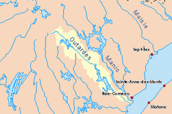 Drainage basin in yellow | |
| Location | |
| Country | Canada |
| Province | Quebec |
| Region | Saguenay–Lac-Saint-Jean, Côte-Nord |
| Physical characteristics | |
| Source | Unnamed wilderness, about 20 km (12 mi) south of the Otish Mts. |
| • location | Mont-Valin |
| • coordinates | 52°04′22″N 70°33′30″W |
| Mouth | Saint Lawrence River |
• location | Pointe-aux-Outardes |
• coordinates | 49°03′43″N 68°27′58″W |
• elevation | 0 m (0 ft) |
| Length | 499 km (310 mi)[1] |
| Basin size | 19,000 km2 (7,300 sq mi)[1] |
| Discharge | |
| • average | 400 m3/s (14,000 cu ft/s)[1] |
At its mouth, the Outardes River widens and flows over a sandbar, making it extremely shallow. There are several islands in Outardes Bay of which the most notable are White Island (île Blanche), a rock of white granite 23 meters (75 ft) high, and Mine Island (île de la Mine), a bare red rock reaching 15 meters (49 ft) high.[2]
The river was first called Cane or Caen River by Jean Alfonse in 1544. The name riviere aux Outardes came in use following its appearance on maps by Jacques-Nicolas Bellin in 1744 and 1764. English maps from the end of the 18th century and early 19th century would show "Bustard River", as a translation of the archaic French word bistarde or oustarde. Today outardes is the Canadian French word for Canada geese. The indigenous Innu called the river Pirebistibit, Peritibistokou, Pletipishtuk, or Piletipîstuk Shipu which means "partridge river".[2]
Among its significant tributaries are:
- Silver River (Rivière à l'argent)
- Villéon River
- Long Wood River (Rivière du Bois Long)
- Matonipi River
The river has been developed for hydro-electric power generation as part of the Manic-Outardes Project in the 1960s and 1970s. There are three power plants:
- Outardes-2 - near the mouth of the river at Chute-aux-Outardes
- Outardes-3
- Outardes-4
References
- Natural Resources Canada, Atlas of Canada - Rivers
- "Rivière aux Outardes" (in French). Commission de toponymie du Québec. Retrieved 2010-10-25.
External links
 Media related to Rivière aux Outardes (Côte-Nord) at Wikimedia Commons
| Authority control |
|
|---|
На других языках
[de] Rivière aux Outardes
Der Fluss Rivière aux Outardes (englisch Outardes River) durchfließt die Verwaltungsregionen Saguenay–Lac-Saint-Jean und Côte-Nord in der kanadischen Provinz Québec.- [en] Rivière aux Outardes (North Shore)
[es] Río Outardes
El río aux Outardes (en francés, Rivière aux Outardes; en inglés, Outardes River, que significa «río de las avutardas») es un río de Canadá que discurre por la región administrativa de Côte-Nord de la provincia de Quebec. Con las fuentes más lejanas del lago Plétipi, el río alcanza los 499 km de longitud, drena una cuenca de 19.900 km² y tiene un caudal aproximado de 389 m³/s.[1]Другой контент может иметь иную лицензию. Перед использованием материалов сайта WikiSort.org внимательно изучите правила лицензирования конкретных элементов наполнения сайта.
WikiSort.org - проект по пересортировке и дополнению контента Википедии