geo.wikisort.org - River
The River Cuckmere rises near Heathfield in East Sussex, England on the southern slopes of the Weald. The name of the river probably comes from an Old English word meaning "fast-flowing", since it descends over 100 m (328 ft) in its initial four miles (6.4 km). It flows into the English Channel, and has the only undeveloped river mouth on the Sussex coast.[1]
| River Cuckmere | |
|---|---|
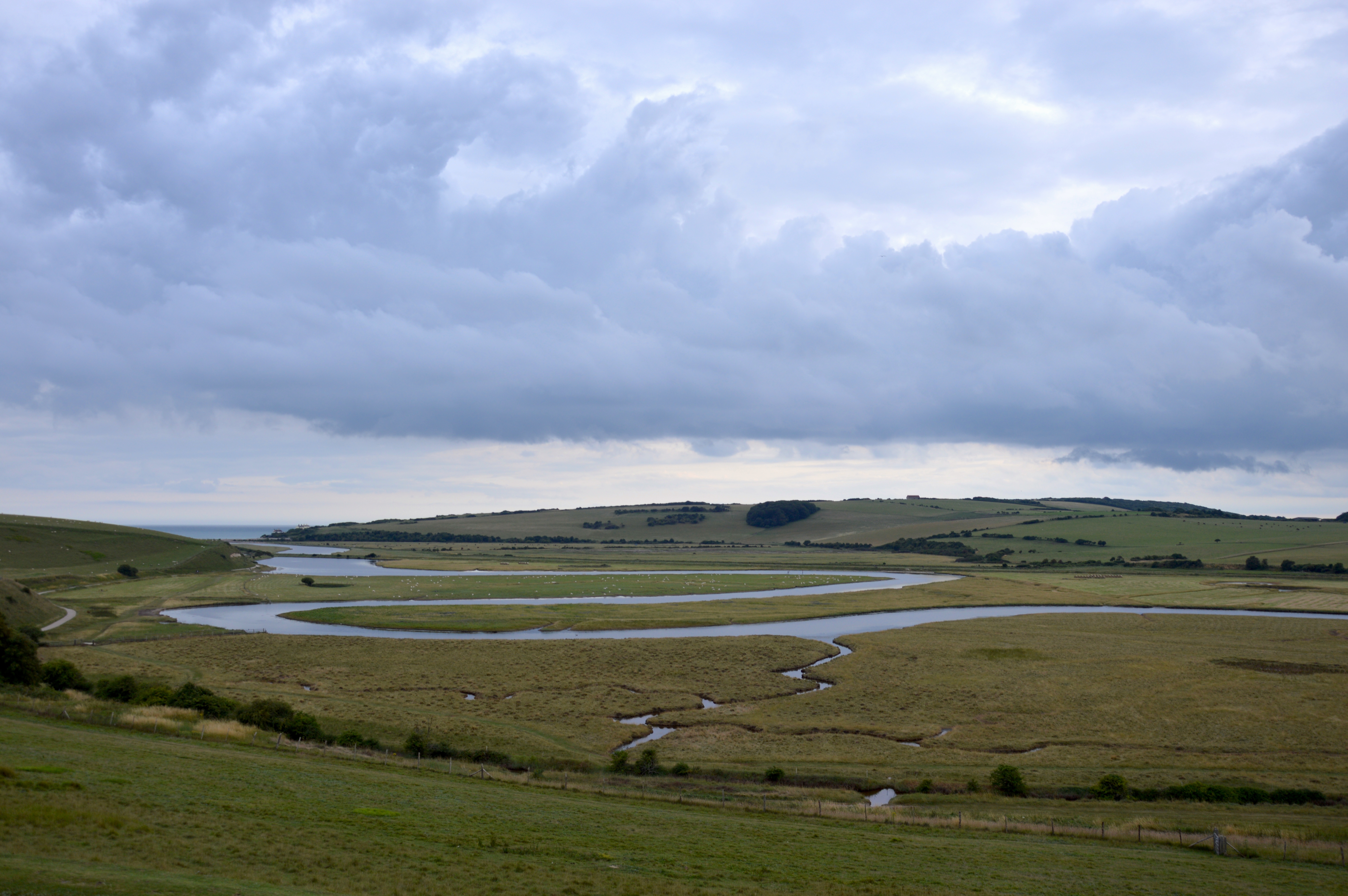
 Looking West over Cuckmere Haven | |
| Location | |
| Country | England (East Sussex) |
| Physical characteristics | |
| Source | |
| • location | Near Heathfield |
| Mouth | |
• location | English Channel |
| River Cuckmere | ||||||||||||||||||||||||||||||||||||||||||||||||||||||||||||||||||||||||||||||||||||||||||||||||||||||||||||||||||||||||||||||||||||||
|---|---|---|---|---|---|---|---|---|---|---|---|---|---|---|---|---|---|---|---|---|---|---|---|---|---|---|---|---|---|---|---|---|---|---|---|---|---|---|---|---|---|---|---|---|---|---|---|---|---|---|---|---|---|---|---|---|---|---|---|---|---|---|---|---|---|---|---|---|---|---|---|---|---|---|---|---|---|---|---|---|---|---|---|---|---|---|---|---|---|---|---|---|---|---|---|---|---|---|---|---|---|---|---|---|---|---|---|---|---|---|---|---|---|---|---|---|---|---|---|---|---|---|---|---|---|---|---|---|---|---|---|---|---|---|
| ||||||||||||||||||||||||||||||||||||||||||||||||||||||||||||||||||||||||||||||||||||||||||||||||||||||||||||||||||||||||||||||||||||||

Description
The river has many tributaries at its upper end, the principal one being the River Bull; and its main channel begins at Hellingly. After crossing the Low Weald area of farmland, the Cuckmere cuts through the South Downs in its own valley. It reaches the English Channel at Cuckmere Haven, between Seaford and the Seven Sisters cliff face. The lower part of its course in the floodplain is marked by meandering.[2] The Cuckmere Valley Nature Reserve is located in the lower estuary portion of the river. The valley is very important for nature conservation. It has been designated a Site of Special Scientific Interest and is part of the South Downs National Park.[3]
History and environmental issues
The Cuckmere Valley civil parish takes its name from the river. In the 19th century, defensive measures were taken to prevent flooding of the upper valley. Shingle was regularly dug from the mouth of the river and the banks were made higher. In 1846, the course of the river was straightened in an artificial cut; the cut mostly prevented flooding upstream, which used to reach to the village of Alfriston. It also provided support for irrigation.[4] In addition, raised river banks, or levees, were constructed to protect areas from flooding. In recent decades, the area has become a major tourist destination, with tourism contributing to the local economy more than does agriculture. The river also stands at the foot of the current Litlington White Horse carved in 1924.
In 2001,[5] the Cuckmere Estuary Partnership was established as a collaboration of the National Trust, Natural England, Environment Agency, East Sussex County Council, Sussex Wildlife Trust, and various other environmental and conservation groups. They are working together to create long-term plans for the natural area. Government guidelines prohibit continuing to maintain hard flood defences where houses are not at risk. In addition, there is growing scientific evidence that the area would be more ecologically rich if allowed to return to its natural state. The partnership and the Environment Agency have proposed estuary restoration, and have been talking to local residents, businesses and visitors about how to proceed in the future. Presently, a shingle beach and raised river banks prevent seawater from penetrating the uppermost[citation needed] areas of the Cuckmere Valley. But the Environment Agency projects that an expected sea level rise due to climate change will increase the already steep costs of physical reinforcement, and current measures will not be sufficient. They intend to stop repair of the levees and to allow the cycle of natural processes, including periodic flooding of the area. The planning collaborators believe that in the long term, restoration of the saltwater estuary and marshes will enrich the ecological habitat, attract more wildlife and improve tourism.[6]
The Environment Agency plans have provoked controversy in the valley, especially among some property owners. Some residents have formed a group called "Rescue the Cuckmere Valley" to try to create an alternative to proposed seasonal flooding.[6][7] In early 2008 the Cuckmere Parish Council issued a public statement urging the Environment Agency to take less drastic steps in the near term, protecting the Cut while developing longer-term plans over the next 25–50 years.[4]
References
- "River Cuckmere", Waterscape, accessed 29 October 2010
- Meander on the River Cuckmere(photo) Archived 10 January 2007 at the Wayback Machine
- "Congratulations to the Environment Agency on the Cuckmere Valley!", Tony Whitbread Blog, 7 January 2009, accessed 29 October 2010
- "'Dangerous message' over Cuckmere's future", Sussex Express Series (Lewes, England), 19 January 2008, accessed 29 October 2010
- https://democracy.eastsussex.gov.uk/Data/Lead%20Member%20for%20Transport%20and%20Environment/20071119/Agenda/LMTE19Nov07item8appendix.pdf [bare URL PDF]
- "Cuckmere Valley flood plans to be revealed", Sussex Express Series (Lewes, England), 30 August 2007, accessed 29 October 2010
- "ALTERNATIVE PLAN FOR CUCKMERE VALLEY?", Eastbourne Herald (Eastbourne, England), 27 April 2004, accessed 29 October 2010
External links
- "The Cuckmere Estuary", Cuckmere Estuary Partnership
| Authority control |
|
|---|
На других языках
[de] Cuckmere
Der Cuckmere River entspringt nahe Heathfield in der südenglischen Grafschaft East Sussex an den südlichen Ausläufern des Weald, eines Kalksteinhöhenzuges in Südengland. Der Name des Flusses stammt vermutlich aus dem Sächsischen und bedeutet so viel wie „der Schnellfließende“. Dies bezieht sich auf den großen Höhenunterschied von 100 m auf den ersten vier Meilen (6,4 km). Der Cuckmere hat viele Nebenflüsse an seinem Oberlauf, von denen der River Bull der bedeutendste ist. Ab Hellingly erreicht der Cuckmere erst seine endgültige Breite. Nachdem er das Farmland südlich des Low Weald durchquert, fließt er durch die South Downs in sein eigenes Tal, das Cuckmere Valley, um östlich von Seaford im Cuckmere Haven nahe den Seven Sisters in den Ärmelkanal zu münden. Der Unterlauf des Cuckmere River ist bemerkenswert durch seinen mäanderartigen Verlauf, der dieser Gegend seinen charakteristischen Reiz verleiht. Das Cuckmere Valley Nature Reserve ist hier beheimatet. Die Gemeinde im Cuckmere Valley hat sich nach ihrem Fluss benannt.- [en] River Cuckmere
[es] Río Cuckmere
El río Cuckmere nace cerca de Heathfield en East Sussex, Inglaterra en las laderas sureñas del Weald. El nombre del río probablemente deriva de una palabra en inglés antiguo que significa que fluye rápido, dado que desciende más de 100 m en sus primeros 6.5 km de recorrido. El río desemboca en el canal de la Mancha, siendo la única desembocadura de un río en la costa de Sussex que no ha sido conformada por el hombre.[1][it] Cuckmere
Il Cuckmere è un fiume dell'Inghilterra. Sorge vicino Heathfield, nell'East Sussex, sulle pendici meridionali del Weald. Il nome del fiume deriva probabilmente da una vecchia parola inglese che significa "a scorrimento veloce", dato che scende per più di 100 metri nelle sue prime quattro miglia (6,4 km). Con uno sbocco finale nel canale della Manica, è l'unica foce non sviluppata sulla costa del Sussex[1].Другой контент может иметь иную лицензию. Перед использованием материалов сайта WikiSort.org внимательно изучите правила лицензирования конкретных элементов наполнения сайта.
WikiSort.org - проект по пересортировке и дополнению контента Википедии