geo.wikisort.org - River
The River Anker is a river in England that flows through the centre of Nuneaton. It is a major tributary of the River Tame, which it joins in Tamworth. The name of the river derives from an old British term for winding river.[1] From source to river mouth at Tamworth is 50 kilometres (31 mi).[2][3][4]
| River Anker | |
|---|---|
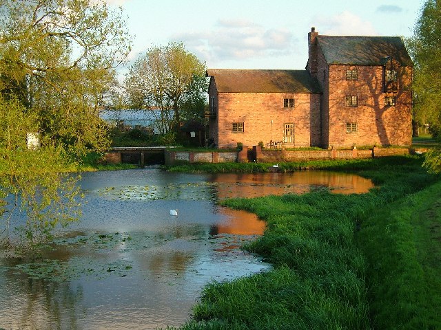 Alders Mill on the River Anker near Pinwall | |
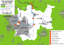 Course and catchment of the River Anker, shown on the eastern side of the Tame catchment | |
| Location | |
| Country | England |
| Counties | Leicestershire, Warwickshire, Staffordshire |
| Towns | Nuneaton, Tamworth |
| Physical characteristics | |
| Source | |
| • location | Wolvey, Warwickshire |
| • coordinates | 52.47590°N 1.34728°W |
| Mouth | River Tame |
• location | Tamworth, Staffordshire |
• coordinates | 52.6315°N 1.6977°W |
| Length | 50 km (31 mi) |
| Discharge | |
| • location | Polesworth |
| • average | 3.2 m3/s (110 cu ft/s) |
| Basin features | |
| Tributaries | |
| • left | Penmire Brook, Innage Brook, River Sence, Griff Brook |
| • right | Wem Brook, Sketchley Brook |
Course
The river rises near Wolvey and flows in a north-westerly direction to pass between Bramcote and Burton Hastings, it is designated a main river at Stretton Baskerville where it also forms the boundary between the boroughs of Rugby, Nuneaton and Bedworth.[5] On the outskirts of Nuneaton it collects the Sketchley Brook, and then passes alongside the Liberty Way sports stadium. At this point the river splits, with a flood relief channel to the north, and the main channel passing through the Nuneaton town centre.[2] The relief channel re-joins beyond the town at Weddington, where the river then continues in the same north-westerly direction to pass the village of Caldecote, then Mancetter (where it is crossed by Watling Street) and Witherley, before reaching Atherstone where it is joined by the River Sence.[3]
Downstream of the confluence, it reaches Grendon and then flows through Polesworth before passing beneath the M42 motorway. Beyond the motorway it passes through Alvecote Pools and meadows, a 128 ha (320 acres) Site of Special Scientific Interest (SSSI) and nature reserve.[6] It continues past Amington Hall before turning south-westerly to flow through Tamworth and join the River Tame near Tamworth Castle.[4]
The Anker is popular with anglers and is known to contain some large pike and chub. Also there are barbel present with fish over 15 lb being reported.
Hydrology
The flow of the Anker has been measured at a gauging station in its lower reaches at Polesworth since 1966. The catchment to the station of 386 square kilometres (149 sq mi) yields an average flow of 3.2 cubic metres per second (110 cu ft/s).[7][8] The highest river level recorded at the station occurred on the 25 November 2012, with a height of 2.57 metres (8 ft 5 in) and a flow of 128 cubic metres per second (4,500 cu ft/s).[9]
The catchment upstream of the station has an average annual rainfall of 653 millimetres (25.7 in) and a maximum altitude of 275 metres (902 ft) near Bardon Hill in Charnwood Forest at the north-eastern edge of the basin.[10]
Flooding
The River Anker has flooded Nuneaton town centre several times in the past, including 1968, prompting the construction of a 600-metre-long (2,000 ft) flood relief channel in Weddington in 1976.[11][12]
In July 2007 the river flooded the Liberty Way pitch, forcing Nuneaton Town and Nuneaton RFC to cancel matches while the river water drained away.[13]
See also
References
- Ekwall, Eilert (1960). The concise Oxford dictionary of English place-names (4 ed.). Oxford: Clarendon Press. p. 10. OCLC 400936.
- "Anker - source to Wem Bk". Catchment Data Explorer. Environment Agency. Retrieved 22 December 2016.
- "Anker from Wem Brook to River Sence". Catchment Data Explorer. Environment Agency. Retrieved 22 December 2016.
- "Anker from River Sence to River Tame". Catchment Data Explorer. Environment Agency. Retrieved 22 December 2016.
- "Warwickshire County Council Strategic Flood Risk Assessment for Local Development Framework" (PDF). warwickshire.gov.uk. 1.7.1 Main rivers and Hydrology: Halcrow. February 2008. p. 11. Retrieved 22 December 2016.
{{cite web}}: CS1 maint: location (link) - "Alvecote Meadows". Warwickshire Wildlife Trust. Archived from the original on 14 June 2012. Retrieved 27 September 2015.
- "28026 - Anker at Polesworth Info". National Rivers Flow Archive. Centre for Ecology & Hydrology. Retrieved 24 December 2016.
- "28026 - Anker at Polesworth Daily Flow Data". National Rivers Flow Archive. Centre for Ecology & Hydrology. Retrieved 24 December 2016.
- "28026 - Anker at Polesworth Peak Flow Data". National Rivers Flow Archive. Centre for Ecology & Hydrology. Retrieved 24 December 2016.
- "28026 - Anker at Polesworth Catchment Info". National Rivers Flow Archive. Centre for Ecology & Hydrology. Retrieved 24 December 2016.
- "Nuneaton Flood Relief Channel Enhancements". therrc.co.uk. The River Restoration Centre. Retrieved 22 December 2016.
- "Riversley Park" (PDF). Weddington Castle. Retrieved 24 December 2016.
- "Floods causes chaos again". Nuneaton News. 23 July 2007. Retrieved 4 January 2017.
External links
 Media related to River Anker at Wikimedia Commons
На других языках
- [en] River Anker
[es] Río Anker
El río Anker es un corto río de Inglaterra. El río fluye a través del centro de Nuneaton hacia Tamworth, en Staffordshire. El río sigue antes de desaguar en Tamworth en el río Tame, un afluente del río Trent . El Anker es popular entre los pescadores y es conocido por contener grandes lucios y bagres.[it] Anker
L'Anker è un fiume in inglese lungo 50 km, affluente in destra orografica del Tame.Другой контент может иметь иную лицензию. Перед использованием материалов сайта WikiSort.org внимательно изучите правила лицензирования конкретных элементов наполнения сайта.
WikiSort.org - проект по пересортировке и дополнению контента Википедии