geo.wikisort.org - River
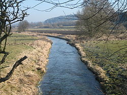
The Riss (German: Riß) is a small river in Baden-Württemberg, south-western Germany, right tributary of the Danube. Its source is in Upper Swabia, between Bad Waldsee and Bad Schussenried. It flows north, through the town of Biberach an der Riss. It then flows into the Danube one mile north of Rißtissen between Ehingen and Erbach, approximately 20 km upstream from Ulm. Its total length is approximately 50 km.
| Riss | |
|---|---|
 | |
| Location | |
| Country | Germany |
| State | Baden-Württemberg |
| Physical characteristics | |
| Source | |
| • location | Upper Swabia |
| • coordinates | 47°57′32″N 9°43′44″E |
| Mouth | |
• location | Danube |
• coordinates | 48°17′8″N 9°49′6″E |
| Length | 49.9 km (31.0 mi) [1] |
| Basin size | 417 km2 (161 sq mi) [1] |
| Basin features | |
| Progression | Danube→ Black Sea |
The Riss gave its name to the Riss glaciation, an ice age.
See also
References
На других языках
[de] Riß
Die Riß [.mw-parser-output .IPA a{text-decoration:none}rɪs] ist ein 49 Kilometer langer Fluss in Oberschwaben im südöstlichen Baden-Württemberg, der beim Ortsteil Ersingen der Kleinstadt Erbach im Alb-Donau-Kreis von rechts und aus dem Süden kommend in die Donau mündet. Sie hat zwei Quellbäche, die längere und bedeutendere, nordwärts fließende Kalte Riß und die kürzere, nordwestwärts laufende Warme Riß, die bei Winterstettendorf zumündet.- [en] Riss
Текст в блоке "Читать" взят с сайта "Википедия" и доступен по лицензии Creative Commons Attribution-ShareAlike; в отдельных случаях могут действовать дополнительные условия.
Другой контент может иметь иную лицензию. Перед использованием материалов сайта WikiSort.org внимательно изучите правила лицензирования конкретных элементов наполнения сайта.
Другой контент может иметь иную лицензию. Перед использованием материалов сайта WikiSort.org внимательно изучите правила лицензирования конкретных элементов наполнения сайта.
2019-2025
WikiSort.org - проект по пересортировке и дополнению контента Википедии
WikiSort.org - проект по пересортировке и дополнению контента Википедии