geo.wikisort.org - River
The Rhumel River (also Rhummel, Rummel, El-Kebîrl; Arabic: وادي الرمال) is the largest river in the Constantine region of Algeria.

Geography
The source of the Rhumel river is in the Ferdjioua (Mila) mountains. From there it meanders through the Constantine plateau, then narrows considerably north of Aïn Smara where it forms an almost complete oxbow before infiltrating, in a SW/NE orientation, the Djebel El Hadjar limestone tables and the Aïn El Bey plateau.
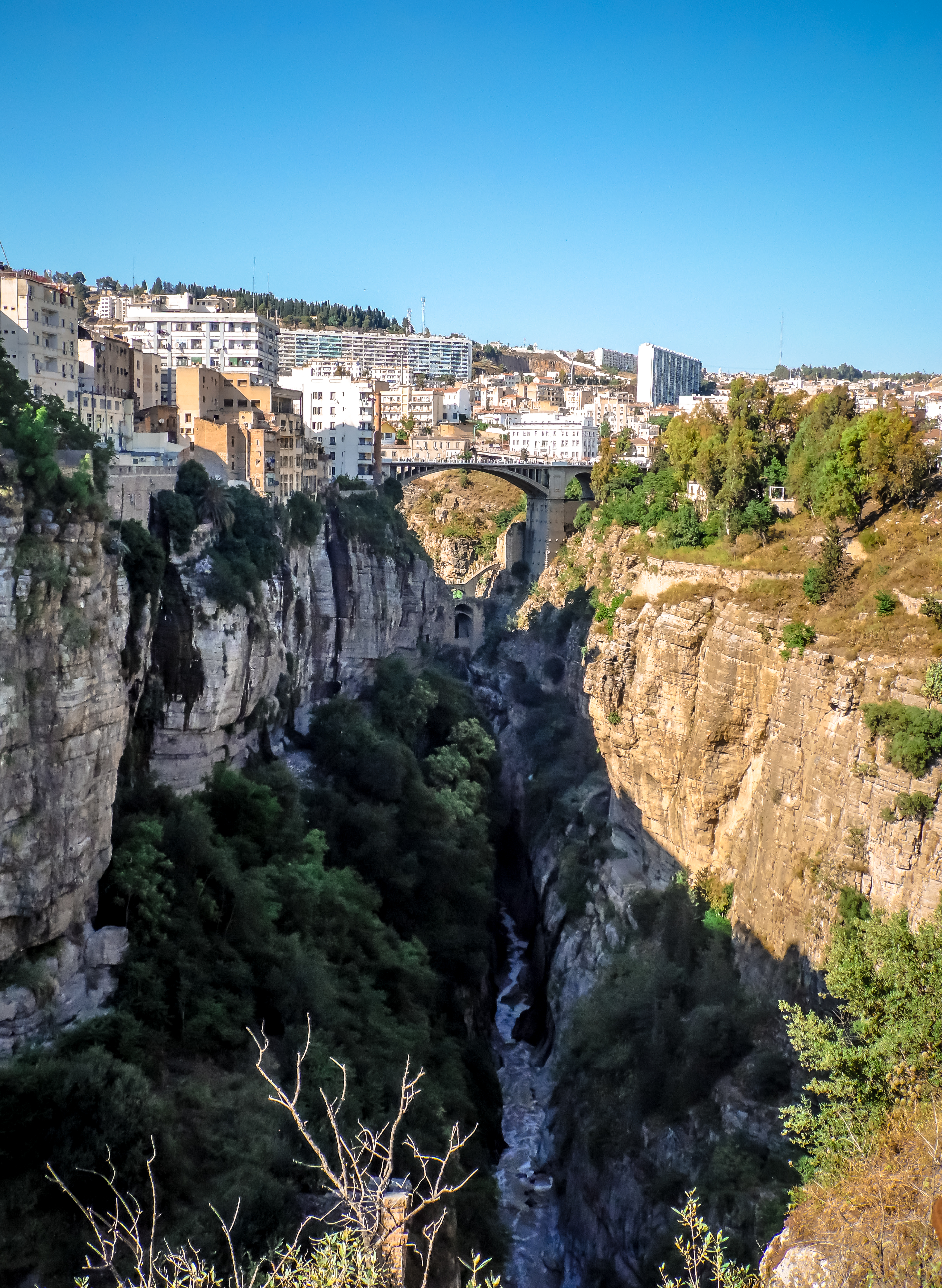
From here, it flows into a narrow ravine near Boussouf, goes through several curves, and becomes very narrow again at a place called "the Roman arches". This leads to the entrance to the Kheneg gorges, whose huge eastern pillar, called "Tiddis mountain", is the site of Tiddis a significant Berber and Roman city that was explored by the archaeologist André Berthier.[1] Not far away is the village of Messaoud Boudjriou (previously Aïn-Kerma) and its old antimony mine.

The lower Rhumel (or Oued-el-Kebir) passes through deep gorges in the Numidian mountains and empties into the sea east of the Gulf of Jijel.

Tributaries
The main tributary of the Rhumel is the Oued-Boumerzoug which rises in the region of Aïn M'lila. Its waters are widely used for irrigation, and the important spa of Ain Fesguia is located towards the head of the valley. This tributary supplies drinking water to the city of Constantine, which is highly prone to flooding being situated at the confluence of the Boumerzoug and the Rhumel.[2]
Another tributary is the Oued Dekri, near the town of Chelghoum Laïd 50 km southwest of Constantine.
History
In ancient times, the river was called Ampsaga.[3][4]
References
- Dussaud, René (1952). "André Berthier. — Tiddis, antique Castellum Tidditanorum". Syria. Archéologie, Art et histoire. 29 (3): 362–363.
- Bourenane, Hamid; Bouhadad, Youcef; Guettouche, Mohamed Said (2019-12-01). "Flood hazard mapping in urban area using the hydrogeomorphological approach: case study of the Boumerzoug and Rhumel alluvial plains (Constantine city, NE Algeria)". Journal of African Earth Sciences. 160: 103602. doi:10.1016/j.jafrearsci.2019.103602. ISSN 1464-343X.
- Février, P.-A.; E. B (1985-11-01). "Ampsaga/Amsaga" (in French). pp. 606–608. ISSN 1015-7344. Retrieved 2019-10-09.
- "L'histoire de la Maurétanie". www.cosmovisions.com. Retrieved 2019-10-09.
Further reading
- P.-A. Février and E. B, "Ampsaga / Amsaga", Berber Encyclopedia, November 1, 1985, p. 606–608 (ISSN 1015-7344, read online, accessed October 9, 2019)
- “The history of Maurétanie. », At www.cosmovisions.com (accessed October 9, 2019)
- Constantine, the most beautiful city you've never heard of
На других языках
[de] Rhumel
Der Rhumel (auch Rhummel, Rummel) ist ein Fluss im nordöstlichen Algerien, der vor allem durch seine tiefe Schlucht in Constantine bekannt ist.- [en] Rhumel River
Другой контент может иметь иную лицензию. Перед использованием материалов сайта WikiSort.org внимательно изучите правила лицензирования конкретных элементов наполнения сайта.
WikiSort.org - проект по пересортировке и дополнению контента Википедии