geo.wikisort.org - River
The Rhine Falls (German: Rheinfall, pronounced [ˈʁaɪ̯nˌfal] (![]() listen), singular) is a waterfall located in Switzerland and the most powerful waterfall in Europe.[2][3][1] The falls are located on the High Rhine on the border between the cantons of Schaffhausen (SH) and Zürich (ZH), between the municipalities of Neuhausen am Rheinfall (SH) and Laufen-Uhwiesen/Dachsen (ZH), next to the town of Schaffhausen in northern Switzerland.
listen), singular) is a waterfall located in Switzerland and the most powerful waterfall in Europe.[2][3][1] The falls are located on the High Rhine on the border between the cantons of Schaffhausen (SH) and Zürich (ZH), between the municipalities of Neuhausen am Rheinfall (SH) and Laufen-Uhwiesen/Dachsen (ZH), next to the town of Schaffhausen in northern Switzerland.
This article needs additional citations for verification. (June 2008) |
| Rhine Falls | |
|---|---|
| German: Rheinfall | |
 Rhine Falls with Rheinfall Bridge and Laufen Castle | |
| Location | On the border between the cantons of Schaffhausen and Zürich next to Schaffhausen, in northern Switzerland |
| Coordinates | 47°40′40″N 8°36′54″E |
| Type | Segmented Block |
| Elevation | 364 m (1,194 ft) |
| Total height | 23 metres (75 ft)[1] |
| Number of drops | 1 |
| Total width | 150 metres (490 ft)[1] |
| Watercourse | Rhine |
| Average flow rate | 250 m3/s (8,800 cu ft/s) during winter, 600 m3/s (21,000 cu ft/s) during summer [1] |

They are 150 metres (490 ft) wide and 23 metres (75 ft) high. In the winter months, the average water flow is 250 m3/s (8,800 cu ft/s), while in the summer, the average water flow is 600 m3/s (21,000 cu ft/s). The highest flow ever measured was more than 1250m3/s in 1999, previous to that the record was 1,250 cubic metres per second (44,000 cu ft/s) in 1965; and the lowest, 95 cubic metres per second (3,400 cu ft/s) in 1921.[1] The falls cannot be climbed by fish, except by eels that are able to worm their way up over the rocks.[citation needed]
Geology

The Rhine Falls were formed in the last ice age, approximately 14,000 to 17,000 years ago, by erosion-resistant rocks narrowing the riverbed. The first glacial advances created today's landforms approximately 500,000 years ago. Up to the end of the Wolstonian Stage approximately 132,000 years ago, the Rhine flowed westwards from Schaffhausen past Klettgau. This earlier riverbed later filled up with gravel.
About 132,000 years ago the course of the river changed southwards at Schaffhausen and formed a new channel, which also filled up with gravel. Part of the Rhine today includes this ancient riverbed.
During the Würm glaciation, the Rhine was pushed far to the south to its present course, over a hard Late Jurassic limestone bed. As the river flowed over both the hard limestone and the easily eroded gravel from previous glaciations, the current waterfall formed about 14,000 to 17,000 years ago. The Rheinfallfelsen, a large rock, is the remnant of the original limestone cliff flanking the former channel. The rock has eroded very little over the years because relatively little sediment comes down the Rhine from Lake Constance.
Economics
The north side of the falls is a millsite. In the 17th century, a blast furnace for smelting iron ore found in the limestone was built. It was in operation until the first half of the 19th century.
In 1887 the ironworks applied for permission to divert between one fifth to one half of the river's flow for electricity generation. The Swiss Alpine Club, the Schweizerische Naturforschende Gesellschaft (a nature group) and several scientific societies opposed the plan.
In 1913 an international competition was held for the best plan for a shipping route between Basel and Lake Constance.
In 1919, a company wanting to build power stations in northern Switzerland were told that any such station at the Rhine Falls "must serve the economic interest of the public".[4]
In 1944, the Swiss Council of States granted permission to build the proposed power station. The permission was to become effective on 1 February 1948, with construction to begin in 1952. But in 1951, the Neuen Helvetischen Gesellschaft (New Swiss Society), under the leadership of Emil Egli, got 150,000 Swiss citizens to sign a petition protesting the project; among the signatories were 49 famous citizens, including Hermann Hesse and Carl Jacob Burckhardt. The petition not only scuttled the power station project, but effectively prevented all future hydropower and navigation engineering projects on the upper Rhine to the present day.[5]
Today, the falls are still under consideration for hydropower projects. If the full water flow were used, the power generated would average approximately 50 MW. The economic value of the falls as a tourist attraction may be greater.
Tourism
The nearest community is Neuhausen am Rheinfall, where tourists can also view the Wörth Castle.[6] Boat trips can be taken up the Rhine to the falls and the Rheinfallfelsen. There are also viewing platforms with views of the falls built on both sides of the Rhine. These are reached via steep and narrow stairs (access by fee on the Schloss Laufen side). Guided tours of various lengths start from Schloss Laufen on the Zürich side of the falls – a youth hostel is also located in Schloss Laufen. Various restaurants are located in Schloss Laufen, Schloss Wörth and the Rheinfall park.
The Rhine Falls are easily accessible by car, bicycle and public transport (SBB railway station "Neuhausen am Rheinfall" on the northern side of the falls and SBB railway station "Schloss Laufen am Rheinfall" on the southern banks of the river). Large pay-parking lots are located on both sides of the falls.

Tourists have been awed by the Rhine Falls for centuries. In the 19th century, the painter J. M. W. Turner made several studies and larger paintings of the falls,[7] and the lyrical poet Eduard Mörike wrote of the falls:
- Halte dein Herz, o Wanderer, fest in gewaltigen Händen!
- Mir entstürzte vor Lust zitternd das meinige fast.
- Rastlos donnernde Massen auf donnernde Massen geworfen,
- Ohr und Auge, wohin retten sie sich im Tumult?
- (Hold your heart, oh traveller, tightly in mighty hands!
- Mine nearly collapsed, shivering with pleasure.
- Restlessly thundering masses thrown upon thundering masses,
- Ear and eye, whither can they save themselves in such an uproar?)
In 1840, author Mary Shelley visited the Falls while on a tour of Europe with her son. She described her visit in a travel narrative that she published in 1844, Rambles in Germany and Italy. She says: "A portion of the cataract arches over the lowest platform, and the spray fell thickly on us, as standing on it and looking up, we saw wave, and rock, and cloud, and the clear heavens through its glittering ever-moving veil. This was a new sight, exceeding anything I had ever before seen; however, not to be wet through, I was obliged quickly to tear myself away.".[8]
Gallery
 Panorama of the Rhine Falls, April 2010.
 A tourist boat near the falls.
 Close-up of the falls.
 Observation deck on the Zürich side.
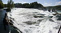 Rheinfall Panorama.
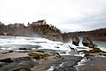 Long exposure photograph of the Rhine Falls with Laufen Castle in the background.


See also
- List of waterfalls by flow rate
References
- "Facts & figures". Schaffhausen, Switzerland: Interessensgemeinschaft Rheinfall. Retrieved 20 August 2019.
- "Northeast Switzerland". Berlitz:Switzerland Pocket Guide. Princeton, NJ: Berlitz Publishing Company. April 1999. p. 39. ISBN 2-8315-7159-6.
- "Lakes and Rivers" (official site). Berne, Switzerland: Presence Switzerland. Retrieved 18 November 2017.
- Uehlinger, A. (1941): Die Naturschutzbestrebungen am Rheinfall. In: Schweizer Naturschutz 7:95–102.
- Alfred Barthelmeß (1988): Landschaft-Lebensraum des Menschen S. 165 ff. Verlag Alber.
- "Archived copy". Archived from the original on 18 August 2009. Retrieved 10 April 2009.
{{cite web}}: CS1 maint: archived copy as title (link) - Turner painting at nationalgalleries.org
- Shelley, Mary (1996). Travel Writing. London: Pickering. p. 102. ISBN 1-85196-084-8.
External links
Authority control | |
|---|---|
| General |
|
| National libraries | |
| Other | |
На других языках
- [en] Rhine Falls
[es] Cataratas del Rin
Las cataratas del Rin (en alemán: Rheinfall) son el mayor salto de agua en la Europa central[1] y se encuentran en el curso del Alto Rin, entre los municipios de Neuhausen am Rheinfall y Laufen-Uhwiesen, cerca de la ciudad de Schaffhausen, en el norte de Suiza, entre los cantones de Zúrich y Schaffhausen. Tienen 150 metros de anchura y 23 m de altura. En los meses de invierno, el caudal medio es de 250 m³/s, mientras que en el verano, el caudal medio es de 700 m³/s. El caudal más alto jamás medido fue 1250 m³/s en 1965, y el más bajo, 95 m³/s en 1921.Другой контент может иметь иную лицензию. Перед использованием материалов сайта WikiSort.org внимательно изучите правила лицензирования конкретных элементов наполнения сайта.
WikiSort.org - проект по пересортировке и дополнению контента Википедии