geo.wikisort.org - River
The Polcevera (in Ligurian Pûçéivia or Ponçéivia) is a 19-kilometre (12 mi) river in Liguria (Italy).
| Polcevera | |
|---|---|
 The Polcevera at its confluence with the Secca | |
 | |
| Location | |
| Country | Italy |
| Physical characteristics | |
| Source | |
| • location | Monte Leco (torr. Verde) |
| Mouth | Ligurian Sea |
• location | Genoa |
• coordinates | 44°24′27″N 8°52′30″E |
• elevation | 0 m (0 ft) |
| Length | 19 km (12 mi)[1][2] |
| Basin size | 140 km2 (54 sq mi)[1] |
Geography
The river is named the Polcevera from Pontedecimo, at the confluence of the Torrente Riccò (left-hand) and torrente Verde (right-hand). Between Pontedecimo and the Ligurian Sea, the Polcevera is 11 kilometres (6.8 mi) long, but its total length including the Torrente Verde is 19 kilometres (12 mi).
From Pontedecimo the Polcevera heads south, and at Bolzaneto it receives the waters of the Torrente Secca, another important left-hand tributary. After being crossed by the Ponte Morandi, a motorway bridge that partially collapsed in August 2018,[3] it ends its course in the Ligurian Sea between Sampierdarena and Cornigliano, two quartieri of Genoa.
The 140-square-kilometre (54 sq mi) drainage basin of the Polcevera is totally included in the Province of Genova.[4] Its highest point is Monte Taccone (1,113 m).[5]
Main tributaries
- Left hand:
- torrente Riccò,
- torrente Secca,
- torrente Geminiano (or Goresina),
- torrente Torbella.
- Right hand:
- torrente Verde,
- torrente Burba,
- torrente Trasta,
- torrente Fegino (or Pianego).
History
The Département du Polcevera or Dipartimento della Polcevera of Ligurian Republic took its name at the end of the 18th century from the stream.[6]
Photo gallery
 Pontedecimo: the confluence of the Torrente Verde (left) and Riccò (right)
 The Polcevera Valley
 The Viadotto Polcevera, a motorway bridge over the Polcevera that partially collapsed in 2018
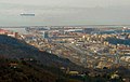 The mouth of the Polcevera; in the background is the Port of Genoa


See also
- Val Polcevera
- List of rivers of Italy
References
- Direzione Pianificazione Generale e di Bacino (2009). PIANO DI BACINO STRALCIO SUL BILANCIO IDRICO - IL BACINO DEL TORRENTE POLCEVERA (PDF). cartogis.provincia.genova.it (in Italian). Provincia di Genova. Archived from the original (PDF) on December 22, 2015. Retrieved December 13, 2015.
- 19 km is the total length of the stream and includes torrente Verde, considered to be the headwaters and primary stream of the Polcevera itself
- Giuffrida, Angela (15 August 2018). "Genoa bridge death toll rises to 35 as more bodies pulled from rubble". The Guardian. Retrieved 15 August 2018.
- 1:25.000 map of the Istituto Geografico Militare, on-line on www.pcn.minambiente.it/viewer
- I.G.C. - Carta dei sentieri 1:50.000 n. 16 Genova - Varazze -Ovada
- Gazzetta universale (in Italian). 1797. Retrieved 2015-12-13.
![]() Media related to Polcevera at Wikimedia Commons
Media related to Polcevera at Wikimedia Commons
Authority control | |
|---|---|
| General |
|
| National libraries | |
| Other | |
На других языках
[de] Polcevera
Der Polcevera (im Ligurischen: Ponçéivia) ist ein Torrentfluss in der norditalienischen Metropolitanstadt Genua. Er durchfließt das gleichnamige Tal und ist nach dem Bisagno der zweitlängste Fluss der Hafenstadt Genua. Im Gegensatz zu letzterem hat er jedoch ein größeres Einzugsgebiet.- [en] Polcevera
[it] Polcevera
Il Polcévera (Pûçéivia o Ponçéivia in ligure) è un torrente il cui corso si sviluppa interamente nella Città metropolitana di Genova attraversando l'omonima valle; è per lunghezza il secondo corso d'acqua della città di Genova, dopo il Bisagno, e il primo per superficie del bacino idrografico.Другой контент может иметь иную лицензию. Перед использованием материалов сайта WikiSort.org внимательно изучите правила лицензирования конкретных элементов наполнения сайта.
WikiSort.org - проект по пересортировке и дополнению контента Википедии