geo.wikisort.org - River
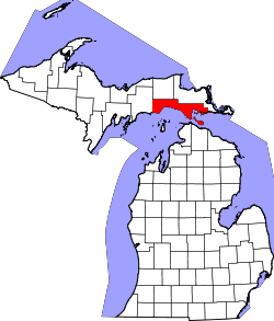
The Pointe aux Chenes River is a 6.2-mile-long (10.0 km)[1] river on the Upper Peninsula of Michigan in the United States. It begins at the outlet of Round Lake and flows south in a winding course through the extensive Pointe aux Chenes Marshes to Lake Michigan.
| Pointe aux Chenes River | |
|---|---|
 | |
| Location | |
| Country | United States |
| Physical characteristics | |
| Source | |
| • location | Michigan |
| Mouth | |
• location | 45°54′58″N 84°52′45″W |
See also
References
- U.S. Geological Survey. National Hydrography Dataset high-resolution flowline data. The National Map, accessed December 19, 2011
Текст в блоке "Читать" взят с сайта "Википедия" и доступен по лицензии Creative Commons Attribution-ShareAlike; в отдельных случаях могут действовать дополнительные условия.
Другой контент может иметь иную лицензию. Перед использованием материалов сайта WikiSort.org внимательно изучите правила лицензирования конкретных элементов наполнения сайта.
Другой контент может иметь иную лицензию. Перед использованием материалов сайта WikiSort.org внимательно изучите правила лицензирования конкретных элементов наполнения сайта.
2019-2026
WikiSort.org - проект по пересортировке и дополнению контента Википедии
WikiSort.org - проект по пересортировке и дополнению контента Википедии