geo.wikisort.org - River
The Pensaukee River is a river located in northeastern Wisconsin.[1] It is a tributary of Lake Michigan via Green Bay.[2]
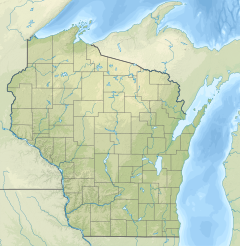
| Pensaukee River Pensaukie River | |
|---|---|
 Flooding on the Pensaukee River near its mouth at Green Bay. | |
  | |
| Location | |
| Country | United States |
| State | Wisconsin |
| Physical characteristics | |
| Source | East of Bonduel |
| • coordinates | 44.7436022°N 88.4103799°W |
| Mouth | Green Bay |
• location | Pensaukee |
• coordinates | 44.8224914°N 87.9017697°W |
• elevation | 584 ft (178 m) |
| Basin features | |
| Tributaries | |
| • left | Spring Creek, North Branch Pensaukee River |
| • right | Brookside Creek |
Route
The river is 47 miles (76 km) long.[3] Its southern branch rises from Pautz Lake in Shawano County and northern branch originates in Pensaukee Lakes in Shawano County.[2] It passes near the communities of Krakow, Klondike, Abrams, and its mouth empties into Green Bay near Pensaukee.[2]
Drainage basin
Its drainage basin covers Oconto County and Shawano County, Wisconsin.[2] The watershed covers 160 square miles (410 km2) of area.[3] 61% of land in the drainage basin has agricultural use.[4]
References
- "Pensaukee River". Geographic Names Information System. United States Geological Survey, United States Department of the Interior. Retrieved October 7, 2020.
- "Advanced Viewer". viewer.nationalmap.gov. National Map. Retrieved September 21, 2020.
- "Upper Green Bay Basin Integrated Management Plan" (pdf). Wisconsin Department of Natural Resources. 2001. p. 23. Retrieved September 21, 2020.
- "Upper Green Bay Basin Integrated Management Plan" (pdf). Wisconsin Department of Natural Resources. 2001. p. 77. Retrieved September 21, 2020.
Текст в блоке "Читать" взят с сайта "Википедия" и доступен по лицензии Creative Commons Attribution-ShareAlike; в отдельных случаях могут действовать дополнительные условия.
Другой контент может иметь иную лицензию. Перед использованием материалов сайта WikiSort.org внимательно изучите правила лицензирования конкретных элементов наполнения сайта.
Другой контент может иметь иную лицензию. Перед использованием материалов сайта WikiSort.org внимательно изучите правила лицензирования конкретных элементов наполнения сайта.
2019-2026
WikiSort.org - проект по пересортировке и дополнению контента Википедии
WikiSort.org - проект по пересортировке и дополнению контента Википедии