geo.wikisort.org - River
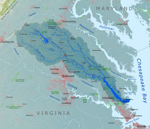
The Pamunkey River is a tributary of the York River, about 93 miles (150 km) long,[1] in eastern Virginia in the United States. Via the York River it is part of the watershed of Chesapeake Bay.
Course
The Pamunkey River is formed by the confluence of the North Anna and South Anna rivers on the boundary of Hanover and Caroline counties, about 5 miles (8 km) northeast of the town of Ashland. It flows generally southeastwardly past the Pamunkey Indian Reservation to the town of West Point, where it meets the Mattaponi River to form the York River. The river's course is used to define all or portions of the southern boundaries of Caroline and King William counties and the northern boundaries of Hanover and New Kent counties.
Variant names
The U.S. Board on Geographic Names settled on "Pamunkey River" as the river's official name in 1892. According to the Geographic Names Information System, it has also been known as:
- Pamauncke River
- Pamoeoncock River
- Pamunky River
- Pemaeoncock
- Yough-ta-mund
- Youghtanund[2]
See also
- List of Virginia rivers
References
- U.S. Geological Survey. National Hydrography Dataset high-resolution flowline data. The National Map, accessed April 1, 2011
- U.S. Geological Survey Geographic Names Information System: Pamunkey River
- Columbia Gazetteer of North America entry
- DeLorme (2005). Virginia Atlas & Gazetteer. Yarmouth, Maine: DeLorme. ISBN 0-89933-326-5.
| Authority control: National libraries |
|---|
This Caroline County, Virginia state location article is a stub. You can help Wikipedia by expanding it. |
This Hanover County, Virginia state location article is a stub. You can help Wikipedia by expanding it. |
This King William County, Virginia state location article is a stub. You can help Wikipedia by expanding it. |
This New Kent County, Virginia state location article is a stub. You can help Wikipedia by expanding it. |
На других языках
- [en] Pamunkey River
[it] Pamunkey River
Il Pamunkey River è un affluente dello York River, e scorre per una lunghezza di 145 chilometri. Si snoda nell'est della Virginia negli Stati Uniti. Attraverso il fiume York, è parte del bacino della Chesapeake Bay.Другой контент может иметь иную лицензию. Перед использованием материалов сайта WikiSort.org внимательно изучите правила лицензирования конкретных элементов наполнения сайта.
WikiSort.org - проект по пересортировке и дополнению контента Википедии