geo.wikisort.org - River
The Ohře (Czech: [ˈoɦr̝ɛ]) or, slightly less commonly in English sources, the Eger (German: [ˈeːɡɐ] (![]() listen), Czech also: Oharka or Ohara, Celtic: Agara, Polish: Ohrza), is a 316 km river[1] in Germany (50 km) and the Czech Republic (266 km),[2] left tributary of the Elbe. The river's catchment area is 5,588 km2,[1] of which 4,601 km2 is in the Czech Republic,[2] 920 km2 in Bavaria[3] and 67 km2 in Saxony. It is the fourth-longest river in the Czech Republic.
listen), Czech also: Oharka or Ohara, Celtic: Agara, Polish: Ohrza), is a 316 km river[1] in Germany (50 km) and the Czech Republic (266 km),[2] left tributary of the Elbe. The river's catchment area is 5,588 km2,[1] of which 4,601 km2 is in the Czech Republic,[2] 920 km2 in Bavaria[3] and 67 km2 in Saxony. It is the fourth-longest river in the Czech Republic.
| Ohře | |
|---|---|
 The Ohře near Budyně nad Ohří | |
| Location | |
| Countries |
|
| Physical characteristics | |
| Source | |
| • location | Fichtel Mountains, Bavaria, Germany |
| Mouth | |
• location | Elbe, Czech Republic |
• coordinates | 50°31′44″N 14°8′11″E |
| Length | 316 km (196 mi) [1] |
| Basin size | 5,588 km2 (2,158 sq mi) [1] |
| Discharge | |
| • average | 38 m3/s (1,300 cu ft/s) |
| Basin features | |
| Progression | Elbe→ North Sea |
Several districts in Germany and the Czech Republic have formed a Euroregion initiative, Euregio Egrensis, to foster co-operation in the region.
Etymology
There is a Czech pun that the Ohře got its name from the river Teplá (meaning "warm" in Czech)—"ohřát" means "to warm up". However, the real origin, which also shows in the German name, is Celtic, from Agara (the "Salmon River"). The records show the name as Agara, Agira, Agra in the 9th century, Egire, Egra or Ogra in the 11th century and Eger in 1472.[4]
Sources
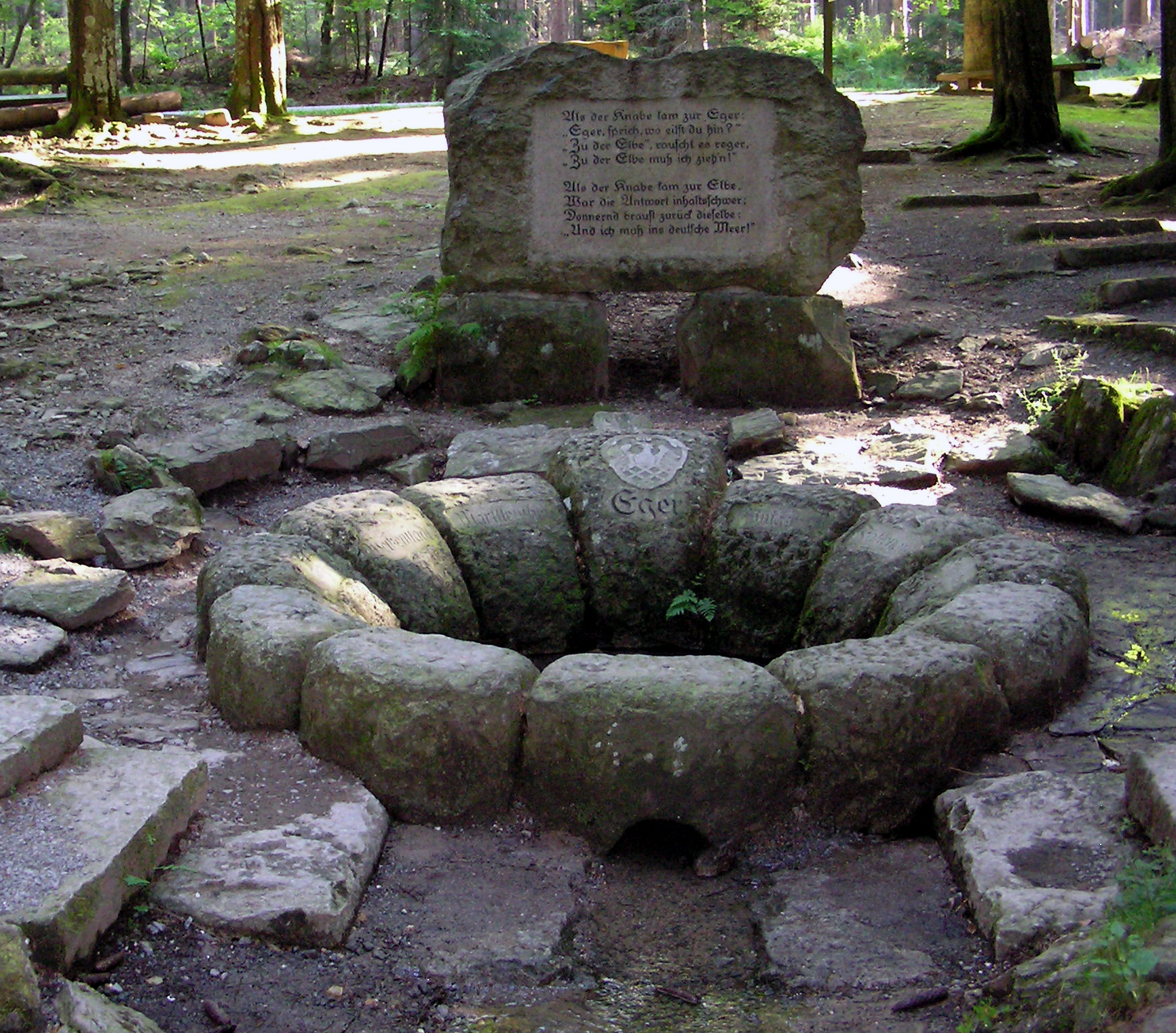
The source of the river Eger is situated in Bavaria at the foot of the Schneeberg in the Fichtel Mountains near the town of Weißenstadt.
The river then flows through Lake Weissenstadt and the towns of Roeslau, Marktleuthen and Hohenberg where it leaves Germany. After about 35 km, the Eger (not to be confused with the town in Hungary), as the river is called in German, crosses the border into the Czech Republic to flow through parts of Bohemia which were known until 1945 as Egerland. The river passes the towns of Cheb, (German: Eger, like the river), Karlovy Vary, Klášterec nad Ohří, Kadaň, Žatec, Louny, and Terezín before flowing into the river Elbe at Litoměřice. The river basin of the Ohře is part of formerly German speaking Sudetenland still having many toponyms from German.
Flow
The highest volume flow rate occurs in spring. The average volume flow rate at the mouth is 37.94 m³/s. The lower part of the river flows through areas with the lowest average precipitation in the Czech Republic (less than 500 mm).
Use
The Ohře is primarily used for irrigation and hydroelectric energy. There are two dams: Skalka (built in 1962–1964, area 378 ha) and Nechranice (built 1961–1968, area 1338 ha). The river flows through the following important towns: Cheb, Sokolov, Loket, Karlovy Vary, Ostrov nad Ohří, Klášterec nad Ohří, Kadaň, Žatec, Louny, Libochovice, Budyně nad Ohří, Terezín and Litoměřice.
Tributaries
- Plesná (German: Fleißenbach) (Left)
- Odrava (German: Wondreb) (Right)
- Libocký potok (L)
- Svatava (German: Zwota, Zwodau) (L)
- Rolava (German: Rohlau) (L)
- Teplá (R)
- Bystřice (L)
- Liboc (R)
- Blšanka (R)
- Chomutovka (L)
References
- Michael Bergemann (2015-07-01). "Gesamtliste der Fließgewässer im Elbeeinzugsgebiet" (PDF; 791 kB) (in German). Arbeitsgemeinschaft für die Reinhaltung der Elbe. Retrieved 2018-03-21.
- "Charakteristiky toků a povodí ČR - Ohře" (in Czech). VÚV TGM. Retrieved 2018-05-08.
- Complete table of the Bavarian Waterbody Register by the Bavarian State Office for the Environment (xls, 10.3 MB)
- Friedrich Umlauft: Geographisches Namenbuch von Österreich-ungarn: Eine Erklärung von Länder-, Völker, Gau-, Fluss und Ortsnamen, A. Hölder, 1886.
External links
- Euregio Egrensis cooperation (in German and Czech)
Authority control | |
|---|---|
| General |
|
| National libraries | |
| Other |
|
На других языках
[de] Eger (Elbe)
Die Eger (tschechisch Ohře) ist ein linker Nebenfluss der Elbe in Deutschland und Tschechien. Sie entspringt bei Weißenstadt im Fichtelgebirge und mündet bei Litoměřice (deutsch Leitmeritz) in die Elbe.- [en] Ohře
[es] Río Ohře
El río Ohře (llamado Eger a su paso por Alemania) es un afluente del río Elba de 316 km de longitud,[1] de los cuales 65 km transcurren por el estado alemán de Baviera y 251 km por la República Checa. Su cuenca hidrográfica abarca un total de 6.255 km², de los cuales 5.614 km² están en Chequia y 641 km² en Alemania.[it] Ohře
L'Ohře (in tedesco: Eger) è un affluente di sinistra dell'Elba. Nasce in Germania dal Fichtelgebirge e attraversa i Monti Metalliferi prima di confluire nell'Elba, per un totale di 316 km, di cui 65 km in Germania e 251 km nella Repubblica Ceca. L'area del bacino del fiume ha una dimensione di 6.255 km², dei quali 5.614 km² nella Repubblica Ceca e 641 km² in Germania.[ru] Огрже
О́грже[1][2] (на тер. Чехии; чеш. Ohře, произношение (инф.)) / Э́гер[3][4] (на тер. Германии; нем. Eger) — река в Чехии и Германии. Длина — 291 км.[источник не указан 414 дней]Другой контент может иметь иную лицензию. Перед использованием материалов сайта WikiSort.org внимательно изучите правила лицензирования конкретных элементов наполнения сайта.
WikiSort.org - проект по пересортировке и дополнению контента Википедии