geo.wikisort.org - River
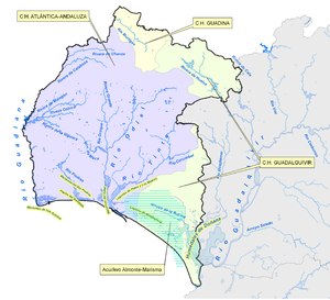
The Odiel (Spanish: Río Odiel) is a river in the Atlantic basin in southern Spain, more precisely in the province of Huelva, Andalusia. It originates at Marimateos in the Sierra de Aracena at an elevation of 660 metres (2,170 ft) above sea level. At the Punta del Sebo, it joins the Rio Tinto to form the Huelva Estuary. Its principal tributaries are the Escalada, Meca, Olivargas, Oraque, Santa Eulalia, and El Villar. Its basin covers 990 square kilometres (380 sq mi).
| Odiel River | |
|---|---|
 View of the Odiel River | |
| Location | |
| Country | Spain |
| Physical characteristics | |
| Source | |
| • location | Sierra de Aracena |
| • elevation | 660 metres (2,170 ft) |
| Mouth | |
• location | Huelva Estuary |
• elevation | 0 metres (0 ft) |
| Basin size | Tinto - Odiel |

In Roman times it was known as the Urius,[1] although some scholars have proposed to identify the Odiel with another ancient name normally associated with the Río Tinto (Luxia).[2] Even before the Romans, its mouth was an important place of commerce, as can be seen by archaeological remnants from Phoenicians and Ancient Greeks, known as the "Huelva Estuary Deposit" (Spanish: Depósito de la Ría de Huelva), dated 1000 BCE.[3]
See also
Notes
- Stanley Jr., F.H.; Knapp, R.C. (7 July 2022). "Urius (river)". Pleiades. New York University. Retrieved 7 July 2022.
- de Alarcâo, Jorge; Álvarez Martínez, José María; Cepas Palanca, Adela; Corzo Sánchez, Ramón (1995). Tabula Imperii Romani Hoja j-29: Lisboa: Emerita - Scallabis - Pax Iulia - Gades. Madrid: Instituto Geografico Nacional. pp. 102–103. ISBN 84-7819-065-1.
- Depósito de la ría Archived 2010-03-27 at the Wayback Machine, Arte e historia. Accessed online 2009-12-24.
На других языках
[de] Odiel
Der Río Odiel ist ein Fluss im Südwesten Spaniens, in der Autonomen Region Andalusien. Er entspringt im Norden der Provinz Huelva in der Sierra de Aracena, die zur Sierra Morena gehört, und fließt in der Nähe der Provinzhauptstadt Huelva in die Ría de Huelva über, wo er sich mit dem Río Tinto vereinigt. Die Ría de Huelva ist eine Ria am Atlantischen Ozean, in den die Wässer des Odiel letztlich gelangen.- [en] Odiel
[it] Odiel
L'Odiel è un fiume spagnolo che nasce nella Sierra de Aracena e, dopo un percorso di 150 km, tutto all'interno della provincia di Huelva, sfocia nell'Oceano Atlantico insieme al Rio Tinto nella baia di Huelva, nel territorio dell'omonima città.[ru] Одьель
Одьель (исп. Rio Odiel) — река в провинции Уэльва, Андалусия, Испания. Берёт начало на высоте 660 метров над уровнем моря (гора Мариматеос, Сьерра-де-Арачена). В Уэльве сливается с Рио-Тинто, образуя общий эстуарий Риа-де-Уэльва. Основные притоки: Эскалада, Мека, Оливаргас, Оракве, Санта-Эйлалиа и Эль-Виллар. Объём бассейна — 990 квадратных километров.Другой контент может иметь иную лицензию. Перед использованием материалов сайта WikiSort.org внимательно изучите правила лицензирования конкретных элементов наполнения сайта.
WikiSort.org - проект по пересортировке и дополнению контента Википедии