geo.wikisort.org - River
The Nossob (also Nosob or Nossop) River (ǂnuse ǃab, Khoikhoi for black river)[1] is a dry river bed in eastern Namibia and the Kalahari region of South Africa and Botswana. It covers a distance of 740 km[2] and last flooded in 1989. The river also lends its name to Nossob camp 25°25′18″S 20°35′47″E in the Kgalagadi Transfrontier Park.[2]
| Nossob River | |
|---|---|
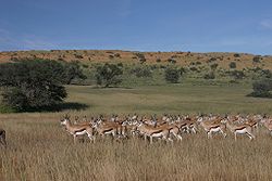
 The Auob River's course, a Nossob tributary | |
 Location of the Nossob River's mouth | |
| Location | |
| Country | Botswana, Namibia and South Africa |
| Physical characteristics | |
| Source | |
| • location | Otjihavera Range, Namibia |
| • elevation | 1,900 m (6,200 ft) |
| 2nd source | Confluence of the Swart-Nossob and Wit-Nossob |
| • elevation | 1,565 m (5,135 ft) |
| Mouth | Molopo River |
• location | Northern Cape, South Africa |
• coordinates | 26°54′15″S 20°41′24″E |
• elevation | 890 m (2,920 ft) |
| Basin features | |
| Tributaries | |
| • left | Black Nossob River, Klein Nossob River |
| • right | White Nossob River, Auob River |


Course
The Nossob has its origin in two main tributaries, the Swart-Nossob and Wit-Nossob, meaning black and white respectively. Both tributaries have their origins in the eastern slopes of the Otjihavera mountain range, east of Windhoek. Their sources are at 1,800 m and over 2,000 m above sea level respectively. The two river beds have their confluence some 80 km south of Gobabis, which is situated on the bank of the Swart-Nossob.
From this confluence the river course passes the settlements of Leonardville and Aranos to arrive at Union's End, South Africa. From Union's End the river bed, forming the Botswana border, meanders through the Kgalagadi Transfrontier Park for a distance of over 200 km. It reaches the southern boundary of the game reserve just north of Twee Rivieren Camp, near its confluence with the Auob river.
In the Kalahari, the Nossob is said to flow about once a century. However, water does flow underground to provide life for grass and camelthorn trees growing in the river bed. The Nossob may flow briefly after large thunderstorms, causing wildlife to flock to the river.
The Nossob ends at a confluence with the Molopo River some 50 km south of Twee Rivieren. The confluence at 26°54′15″S 20°41′24″E is still 890 m above sea level. The Molopo is in turn a tributary of the Orange River, which it meets downstream of Augrabies Falls.
Dams
White Nossob
- Otjivero Dam, near the settlements of Otjivero and Omitara[3]
Oanob River
The Oanob River, a tributary of the Auob River features two dams:
- Nauspoort Dam
- Oanob Dam
See also
- Kgalagadi Transfrontier Park
Notes
- du Plessis, E.J. (1973). Suid-Afrikaanse berg- en riviername. Tafelberg-uitgewers, Cape Town. p. 293. ISBN 0-624-00273-X.
- Raper, P.E. (2004). South African Place Names. Jonathan Ball, Jhb & Cape Town. p. 278. ISBN 1-86842-190-2.
- "Otjivero Dam". namibweb.com. Retrieved 28 October 2020.
External links
На других языках
[de] Nossob
Der Nossob (khoekhoegowab ǂnuse ǃab[Khi 1])[2] ist ein Rivier in der Kalahari, im Südosten Namibias, im Südwesten Botswanas und im Nordwesten Südafrikas. Er erstreckt sich über eine Länge von 740 Kilometer[3] und führte zuletzt 1989 Wasser.[3]- [en] Nossob River
[ru] Нособ
Нособ (англ. Nossob River) — сухое речное русло на востоке Намибии, юго-западе Ботсваны и севере ЮАР. Имеет длину около 740 км[1]. Последний раз заполнялось водой в 1989 году. Частичное заполнение было зафиксировано в 2011 году в районе намибийского поселения Леонардвиль. Нособ берёт начало от слияния двух верховий, рек Сварт-Нособ и Вит-Нособ (что означает «чёрный» и «белый» Нособ соответственно), в 80 км к югу от города Гобабис. Обе эти реки, в свою очередь, начинаются на восточных склонах горного хребта Отджихавера к востоку от Виндхука. Течёт преимущественно в юго-восточном направлении. Покидая территорию Намибии, Нособ формирует участок границы между Ботсваной и ЮАР. Русло впадает в реку Молопо, которая в свою очередь является притоком реки Оранжевая, на высоте 890 м над уровнем моря.Другой контент может иметь иную лицензию. Перед использованием материалов сайта WikiSort.org внимательно изучите правила лицензирования конкретных элементов наполнения сайта.
WikiSort.org - проект по пересортировке и дополнению контента Википедии