geo.wikisort.org - River
Nistowiak Falls, at 10 metres (33 ft), is one of the highest waterfalls in the province of Saskatchewan, Canada. The falls are on the Rapid River, which flows north from Iskwatikan Lake into Nistowiak Lake on the Churchill River. Nistowiak is a Cree word referring to the convergence of waters.[1]
| Nistowiak Falls | |
|---|---|
 | |
| Coordinates | 55.40°N 104.3671°W |
| Type | Cataract |
| Total height | 10 metres (33 ft) |
| Watercourse | Rapid River |
Access
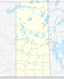
The closest access is from the Stanley Mission Indian reserve #157,[2] part of the La Ronge Indian Band.[3] Stanley Mission is at the north end of Highway 915, which connects via Highway 102 to Highway 2 in La Ronge. From Stanley Mission, it is about 20 kilometres (12 mi) east by water on the Churchill River. The falls, Iskwatikan Lake and the south shore of Nistowiak Lake are within Lac La Ronge Provincial Park.[4] There is a tourist fishing camp on the west side of the Rapid River at Nistowiak Lake called "Jim's Camp". Some minimal supplies can be obtained there. The trail to the falls goes through the fishing camp for part of the way. Lac la Ronge drains into the Churchill River through these falls.
Photos
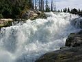 View of upper Nistowiak Falls
 view of lower reaches of Nistowiak Falls

References
- "Natural Resources Canada-Canadian Geographical Names (Nistowiak Falls)". Retrieved 2015-01-31.
- Stanley Mission First Nation website
- "La Ronge Indian Band website". Archived from the original on 2007-08-18. Retrieved 2007-08-09.
- Lac La Ronge Provincial Park website Archived 2006-08-27 at the Wayback Machine
External links
Другой контент может иметь иную лицензию. Перед использованием материалов сайта WikiSort.org внимательно изучите правила лицензирования конкретных элементов наполнения сайта.
WikiSort.org - проект по пересортировке и дополнению контента Википедии