geo.wikisort.org - River
The Neukölln Ship Canal, or Neuköllner Schiffahrtskanal, is a 4.1-kilometre (2.5 mi) long canal in Berlin, Germany. It connects with the Landwehr Canal at its northern end, and with the Teltow Canal and the Britz Canal at its southern end.[1]
This article relies largely or entirely on a single source. (January 2016) |
| Neukölln Ship Canal | |
|---|---|
 The Lohmuehlenbruecke across the Neukölln Ship Canal | |
| Specifications | |
| Length | 4.1 km (2.5 miles) |
| Geography | |
| Start point | Landwehr Canal |
| End point | Teltow Canal and the Britz Canal |
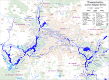
The canal has a single lock, the Schleuse Neukölln, towards its southern end. The lock rises from the level of the Landwehr Canal to that of the Teltow and Britz canals.[1]
References
- Sheffield, Barry (1995). Inland Waterways of Germany. St Ives: Imray Laurie Norie & Wilson. p. 118. ISBN 0-85288-283-1.
Wikimedia Commons has media related to Neuköllner Schiffahrtskanal.
This Berlin location article is a stub. You can help Wikipedia by expanding it. |
This article related to water transport is a stub. You can help Wikipedia by expanding it. |
This article about a Berlin building or structure is a stub. You can help Wikipedia by expanding it. |
На других языках
[de] Neuköllner Schifffahrtskanal
Der Neuköllner Schifffahrtskanal (auch: Neuköllner Verbindungskanal) ist eine Wasserstraße im Nordosten des Berliner Bezirks Neukölln. Bei seiner Anlage hieß er Rixdorfer Schiffahrtskanal.[1]- [en] Neukölln Ship Canal
Текст в блоке "Читать" взят с сайта "Википедия" и доступен по лицензии Creative Commons Attribution-ShareAlike; в отдельных случаях могут действовать дополнительные условия.
Другой контент может иметь иную лицензию. Перед использованием материалов сайта WikiSort.org внимательно изучите правила лицензирования конкретных элементов наполнения сайта.
Другой контент может иметь иную лицензию. Перед использованием материалов сайта WikiSort.org внимательно изучите правила лицензирования конкретных элементов наполнения сайта.
2019-2026
WikiSort.org - проект по пересортировке и дополнению контента Википедии
WikiSort.org - проект по пересортировке и дополнению контента Википедии