geo.wikisort.org - River
Mountain Fork, also known as the Mountain Fork of the Little River, is a 98-mile-long (158 km)[1] tributary of the Little River in western Arkansas and southeastern Oklahoma in the United States. Via the Little and Red rivers, it is part of the watershed of the Mississippi River.
Course


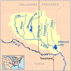
The Mountain Fork rises in the Ouachita Mountains in Le Flore County, Oklahoma, and then flows southeastwardly into Polk County, Arkansas, then southwestwardly into McCurtain County, Oklahoma, where it turns southward for the remainder of its course. It joins the Little River in McCurtain County, 10 miles (16 km) southeast of Broken Bow.
In its upper course, the river flows through a portion of the Ouachita National Forest. In McCurtain County, the river is dammed to form Broken Bow Lake. Nancy Branch is a tributary of the river.
Discharge
At Eagletown, the river has a mean annual discharge of 1,430 cubic feet per second (40 cubic metres per second).[2]
Recreation and Conservation
The Upper Mountain Fork River offers 31.7 miles (51.0 km) of canoeing or kayaking from near Hatfield, Arkansas to Broken Bow Lake. This part of the river has Class I and II rapids. clear water, fishing for Smallmouth bass and other species, and excellent scenery with pine forests covering the hills and bluffs along the river's course. Water levels in the river are generally adequate for boating year-round.[3] On the upper portion of Broken Bow Lake is the McCurtain County Wilderness Area, an Oklahoma State-owned 14,000 acres (5,700 ha) tract which contains the largest remaining virgin Shortleaf Pine/hardwood forest in the nation. Hunting is permitted in the Wilderness Area.[4]
Below Broken Bow dam and lake, the 18.8 miles (30.3 km) of the Lower Mountain Fork is described as the "consistently flowing and best whitewater stream" in Oklahoma. Class I and II rapids are found in the upper part of this section and paddlers must navigate waterfalls with a four foot (1.2 mt) drop. Bald Cypress trees line and, in some places, grow in the river.[3] The cool waters issuing below Broken Bow dam provide year round habitat and fishing for Rainbow and Brown Trout which are stocked regularly throughout the year.[5] In 2008, a 17 pound 4 ounce (7.8 kilogram) Brown Trout was caught by an angler in the Mountain Fork.[6]
See also
- List of Arkansas rivers
- List of Oklahoma rivers
References
- U.S. Geological Survey. National Hydrography Dataset high-resolution flowline data. The National Map, accessed June 3, 2011
- "USGS Surface Water data for Oklahoma: USGS Surface-Water Annual Statistics".
- "Mountain Fork River" http://southwestpaddler.com/docs/littleok9.html, accessed 20 Apr 2013
- "McCurtain County Wilderness Area" http://www.wildlifedepartment.com/factsmaps/wma/mccurtain.htm, accessed 20 Apr 2013
- "Lower Mountain Fork River Trout Regulations" http://www.beaversbend.com/fishing.html, accessed 20 Apr 2013
- "Record Brown Trout" https://www.wildlifedepartment.com/recordfish/brownshattered.htm, accessed 20 Apr 2013
- Columbia Gazetteer of North America
- DeLorme (2004). Arkansas Atlas & Gazetteer. Yarmouth, Maine: DeLorme. ISBN 0-89933-345-1.
- DeLorme (2003). Oklahoma Atlas & Gazetteer. Yarmouth, Maine: DeLorme. ISBN 0-89933-283-8.
- U.S. Geological Survey Geographic Names Information System: Mountain Fork
External links
- Mountain Fork River - Video footage of the area and a list of local activities and resources.
- Oklahoma Digital Maps: Digital Collections of Oklahoma and Indian Territory
| Authority control: National libraries |
|---|
Другой контент может иметь иную лицензию. Перед использованием материалов сайта WikiSort.org внимательно изучите правила лицензирования конкретных элементов наполнения сайта.
WikiSort.org - проект по пересортировке и дополнению контента Википедии