geo.wikisort.org - River
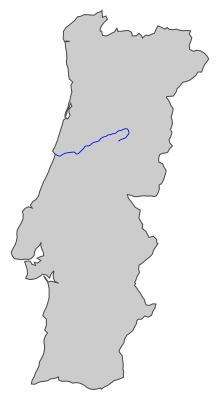
The Rio Mondego (Portuguese pronunciation: [ˈʁi.u mõˈdeɣu]) or Mondego River is the longest river entirely within Portuguese territory.[1] It has its source in Serra da Estrela, the highest mountain range in mainland Portugal (i.e. excluding the Portuguese islands). It runs 234 kilometres (145 mi) from the Gouveia municipality, at 1,425 metres (4,675 ft) above sea level in Serra da Estrela, to its mouth in the Atlantic Ocean next to the city of Figueira da Foz.
Etymology
The river's name is believed to be derived from the pre-Roman, Hispano-Celtic word Munda or Monda — by which names it had been referred to in the classical antiquity by Pliny and Ptolemy —, later latinised into Mondæcus until evolving into the present name.[2][3]
Geography
It flows through the districts of Guarda, Viseu and Coimbra, all in Central Portugal. It flows near the towns of Celorico da Beira, Fornos de Algodres, Nelas, Tábua, Carregal do Sal and Mortágua and the cities of Seia, Gouveia, Guarda, Oliveira do Hospital, Mangualde and Santa Comba Dão, before crossing the town of Penacova. The river widens by the city of Coimbra (a historical city, the largest of the region, with a university as a World Heritage Site), and the Montemor-o-Velho municipality (known for its castle and rice fields), before reaching the Atlantic Ocean at the city of Figueira da Foz.[4]
There are two main dams along the Mondego, the Aguieira Dam and the Raiva Dam, as well as a smaller one at Coimbra's main bridge.[5]
Tributaries
One of its tributaries is the Rio Dão, which gives its name to the Dão wine region. Another is the Alva River, which enters the Mondego just before Penacova.[citation needed] The Ceira River enters the Mondego just south of Coimbra along National Road 17.[6]
Gallery
 Coimbra and the Mondego
 Mondego bank in Coimbra
 Rainha Santa Isabel Bridge over the Mondego
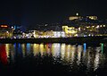 Mondego in Coimbra by night
 Mondego as it passes Caldas de Felgueira, Nelas, Portugal


See also
- Serra da Estrela
- Baixo Mondego
- Beiras
- Coimbra
- Figueira da Foz
- Coimbra University
- Castles in Portugal
- Cities in Portugal
References
- "Mondego" by Manuel Pinheiro, Final Project of a masters's degree in Wildlife Documentary Production from the University of Salford. Film marked with a distinction. Filmed in Portugal during May/June 2011. A voyage by the Mondego river's wildlife from the mountains to the sea.
- "Mondego | Definição ou significado de Mondego no Dicionário Infopédia de Toponímia". Infopedia.pt.
- Chao, Eduardo (1849). Cuadros de la geografia historica de Espana desde los primeros tiempos historicos hasta el dia (Etc.). p. 188.
- "River Mondego". Mapmywalk.com. Retrieved 7 June 2022.
- Dams in Central Portugal. Retrieved 7 November 2022.
- "40°11'02.0"N 8°23'46.0"W". Google.com. Retrieved 7 June 2022.
Authority control | |
|---|---|
| General |
|
| National libraries | |
| Other |
|
This Coimbra location article is a stub. You can help Wikipedia by expanding it. |
This Guarda location article is a stub. You can help Wikipedia by expanding it. |
This Viseu location article is a stub. You can help Wikipedia by expanding it. |
На других языках
[de] Mondego
Der Mondego ist ein Fluss in Portugal. Er ist 234 km lang und der längste Fluss, der ausschließlich durch Portugal fließt. Er entspringt in 1425 m Höhe in der Serra da Estrela und mündet bei Figueira da Foz in den Atlantik. An seiner Quelle trägt er den Namen Mondeguinho („kleiner Mondego“). In römischer Zeit hieß der Fluss Munda.- [en] Mondego River
[it] Mondego
Il Mondego è un fiume del Portogallo.[ru] Мондегу
Монде́гу (порт. Mondego, лат. Munda) — река в Португалии; крупнейшая река, русло которой полностью находится на территории Португалии. Длина — 220 км. Площадь водосборного бассейна — 6772 км²[1].Другой контент может иметь иную лицензию. Перед использованием материалов сайта WikiSort.org внимательно изучите правила лицензирования конкретных элементов наполнения сайта.
WikiSort.org - проект по пересортировке и дополнению контента Википедии