geo.wikisort.org - River
The Miners River is a river on the Upper Peninsula of Michigan in the United States. It is the largest river in the Pictured Rocks National Lakeshore. Miners River has its origin outside of the National Lakeshore, north of Indian Town in the Hiawatha National Forest, and flows 12.4 miles (20.0 km) into Lake Superior.[2] Miners Lake and Miners Falls are found along the river. The river empties into Lake Superior at the western end of Miners Beach. It is popular for tourism and fishing.
 View of Miners Falls on Miners River
 A view of Miners River below Miners Falls
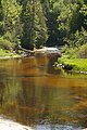 Miners River near the outlet to Lake Superior


| Miners River | |
|---|---|
 Mouth of Miners River at Miners Beach | |
| Location | |
| Country | United States |
| Physical characteristics | |
| Source | |
| • location | Alger County, Michigan |
| • coordinates | 46.4294°N 86.5763°W[1] |
| Mouth | |
• location | Lake Superior, Michigan |
• coordinates | 46.4952°N 86.5454°W |
| Length | 12.4 mi (20.0 km) |
See also
References
- "Miners River". Geographic Names Information System. United States Geological Survey.
- U.S. Geological Survey. National Hydrography Dataset high-resolution flowline data. The National Map Archived 2012-03-29 at the Wayback Machine, accessed January 3, 2012
Wikimedia Commons has media related to Miners River.
This Alger County, Michigan location article is a stub. You can help Wikipedia by expanding it. |
Текст в блоке "Читать" взят с сайта "Википедия" и доступен по лицензии Creative Commons Attribution-ShareAlike; в отдельных случаях могут действовать дополнительные условия.
Другой контент может иметь иную лицензию. Перед использованием материалов сайта WikiSort.org внимательно изучите правила лицензирования конкретных элементов наполнения сайта.
Другой контент может иметь иную лицензию. Перед использованием материалов сайта WikiSort.org внимательно изучите правила лицензирования конкретных элементов наполнения сайта.
2019-2026
WikiSort.org - проект по пересортировке и дополнению контента Википедии
WikiSort.org - проект по пересортировке и дополнению контента Википедии