geo.wikisort.org - River
Middlebush Brook is a tributary of Six Mile Run in Somerset County, New Jersey in the United States.
| Middlebush Brook | |
|---|---|
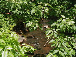
 Middlebush Brook crossing Blackwells Mills Road, near its mouth | |
 Middlebush Brook map | |
| Location | |
| Country | United States |
| Physical characteristics | |
| Source | |
| • coordinates | 40°29′21″N 74°30′41″W |
| Mouth | |
• coordinates | 40°28′21″N 74°33′02″W |
• elevation | 59 ft (18 m) |
| Basin features | |
| Progression | Six Mile Run, Millstone River, Raritan River, Atlantic Ocean |
As its name suggests, Middlebush Brook begins in the town of Middlebush. Its source is at 40°29′21″N 74°30′41″W,[1] just south of Hamilton Street in north-western Franklin Park.
Tributaries
This stream has several unnamed tributaries. One closely parallels South Middlebush Road before splitting into two more tributaries. One of them ends in a development near Amwell Road (the same road as Hamilton Street), while the other is a drain for a residential development.
Course
Middlebush Brook starts at 40°29′21″N 74°30′41″W[1] in a commercial development. It exits the commerce area and flows through a marsh, then crossing Bennetts Lane. It runs behind a cow farm then crosses South Middlebush Road right above Blackwells Mills Road. It crosses Blackwells Mills Road a little later on, then drains into Six Mile Run at 40°28′21″N 74°33′02″W.[1]
It has several branches, including one that runs for a distance along South Middlebush Road and one that flows to a residential development near CR-514 (Amwell Road).
Accessibility
This stream flows through wooded areas downstream, where it is not accessible easily. It is accessible upstream though, where it flows through a residential development.
It may be accessed, though with difficulty, at the Blackwells Mills Road crossing.
Terrain
This stream has a streambed composed of small boulders, making it difficult to walk on. Some locations have pebbles. It is not muddy and therefore is not suitable for frogs.
Sister tributaries
- Cross Brook
- Steep Hill Brook
- Nine Mile Run
Gallery
- Middlebush Brook at Blackwells Mills Road, just before its mouth
- Middlebush Brook at Blackwells Mills Road, just before its mouth
- Middlebush Brook crossing South Middlebush Road
- Branch of Middlebush Brook running alongside South Middlebush Road
- Branch of Middlebush Brook crossing South Middlebush Road
- Branch of Middlebush Brook mentioned above running through a dairy farm
- Middlebush Brook crossing Bennets Lane
- Middlebush Brook crossing Bennets Lane, lost in a marsh
See also
References
- "USGS GNIS - Middlebush Brook". USGS. Retrieved 9 June 2010.
External links
Другой контент может иметь иную лицензию. Перед использованием материалов сайта WikiSort.org внимательно изучите правила лицензирования конкретных элементов наполнения сайта.
WikiSort.org - проект по пересортировке и дополнению контента Википедии


