geo.wikisort.org - River
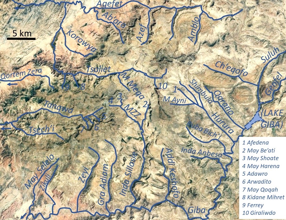
May Harena is a river of the Nile basin. Rising in the mountains of Dogu’a Tembien in northern Ethiopia, it flows eastward to empty finally in Giba and Tekezé River.[1]
| May Harena | |
|---|---|
 The May Harena River at Harena | |
 May Harena in Dogu’a Tembien | |
| Etymology | After the homonymous village |
| Location | |
| Country | Ethiopia |
| Region | Tigray Region |
| District (woreda) | Dogu’a Tembien |
| Physical characteristics | |
| Source | |
| • location | Valley head east of Hagere Selam |
| • elevation | 2,480 m (8,140 ft) |
| Mouth | May Zegzeg River |
• location | May Addi Abagiè at the border of Mika'el Abiy and Haddinnet municipalities |
• coordinates | 13.644°N 39.194°E |
• elevation | 2,270 m (7,450 ft) |
| Length | 2.1 km (1.3 mi) |
| Width | |
| • average | 10 m (33 ft) |
| Basin features | |
| River system | Seasonal river |
| Landmarks | Hagere Selam town |
| Topography | Mountains and deep gorges |
Characteristics
It is a confined ephemeral river with an average slope gradient of 100 metres per kilometre.[2]
Hydrology
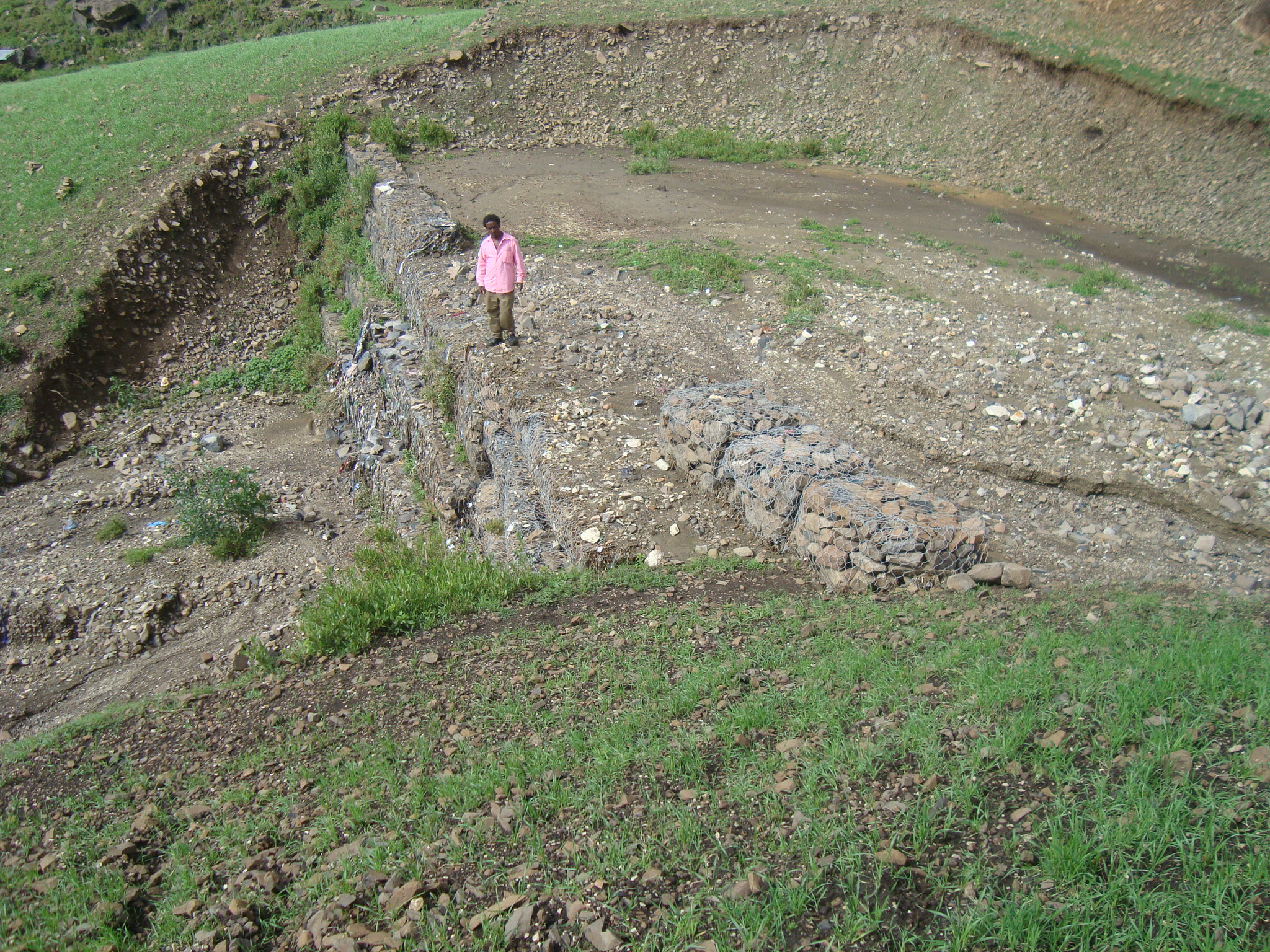
River discharge in May Harena is highly seasonal, with the river only carrying water in the rainy season, after rain events. The problem is exacerbated by the fact that most of the urban drainage from Hagere Selam is rapidly directed to this river. Conservation activities (such as those by the Selam WatSani project aim at buffering these floods. There is however a strong contrast with better regularised adjacent May Sho'ate River.
Flash floods and flood buffering
Runoff mostly happens in the form of high runoff discharge events that occur in a very short period (called flash floods). These are related to the steep topography, often little vegetation cover and intense convective rainfall. The peaks of such flash floods have often a 50 to 100 times larger discharge than the preceding baseflow.[2] The magnitude of floods in this river has somewhat been decreased due to interventions in the catchment. On some steep slopes, exclosures have been established; the dense vegetation largely contributes to enhanced infiltration, less flooding and better baseflow.[3] Physical conservation structures such as stone bunds[4][5] and check dams also intercept runoff.[6][7]

Boulders and pebbles in the river bed
Boulders and pebbles encountered in the river bed can originate from any location higher up in the catchment. In the uppermost stretches of the river, only rock fragments of the upper lithological units will be present in the river bed, whereas more downstream one may find a more comprehensive mix of all lithologies crossed by the river. From upstream to downstream, the following lithological units occur in the catchment.[8]
- Upper basalt
- Interbedded lacustrine deposits
- Lower basalt
- Amba Aradam Formation
- Antalo Limestone

Trekking along the river
Trekking routes have been established across and along this river.[9] The tracks are not marked on the ground but can be followed using downloaded .GPX files.[10] Trek 12 V runs parallel to the river, on its northern side.
See also
- List of Ethiopian rivers
References
- Jacob, M. and colleagues (2019). Geo-trekking map of Dogu'a Tembien (1:50,000). In: Geo-trekking in Ethiopia's Tropical Mountains - The Dogu'a Tembien District. SpringerNature. ISBN 978-3-030-04954-6.
- Amanuel Zenebe, and colleagues (2019). The Giba, Tanqwa and Tsaliet rivers in the headwaters of the Tekezze basin. In: Geo-trekking in Ethiopia's Tropical Mountains - The Dogu'a Tembien District. SpringerNature. doi:10.1007/978-3-030-04955-3_14. ISBN 978-3-030-04954-6.
- Descheemaeker, K. and colleagues (2006). "Runoff on slopes with restoring vegetation: A case study from the Tigray highlands, Ethiopia". Journal of Hydrology. 331 (1–2): 219–241. doi:10.1016/j.still.2006.07.011. hdl:1854/LU-378900.
- Nyssen, Jan; Poesen, Jean; Gebremichael, Desta; Vancampenhout, Karen; d'Aes, Margo; Yihdego, Gebremedhin; Govers, Gerard; Leirs, Herwig; Moeyersons, Jan; Naudts, Jozef; Haregeweyn, Nigussie; Haile, Mitiku; Deckers, Jozef (2007). "Interdisciplinary on-site evaluation of stone bunds to control soil erosion on cropland in Northern Ethiopia". Soil and Tillage Research. 94 (1): 151–163. doi:10.1016/j.still.2006.07.011. hdl:1854/LU-378900.
- Gebeyehu Taye and colleagues (2015). "Evolution of the effectiveness of stone bunds and trenches in reducing runoff and soil loss in the semi-arid Ethiopian highlands". Zeitschrift für Geomorphologie. 59 (4): 477–493. doi:10.1127/zfg/2015/0166.
- Nyssen, J.; Veyret-Picot, M.; Poesen, J.; Moeyersons, J.; Haile, Mitiku; Deckers, J.; Govers, G. (2004). "The effectiveness of loose rock check dams for gully control in Tigray, Northern Ethiopia". Soil Use and Management. 20: 55–64. doi:10.1111/j.1475-2743.2004.tb00337.x.
- Etefa Guyassa and colleagues (2017). "Effects of check dams on runoff characteristics along gully reaches, the case of Northern Ethiopia". Journal of Hydrology. 545 (1): 299–309. doi:10.1016/j.jhydrol.2016.12.019. hdl:1854/LU-8518957.
- Sembroni, A.; Molin, P.; Dramis, F. (2019). Regional geology of the Dogu'a Tembien massif. In: Geo-trekking in Ethiopia's Tropical Mountains — The Dogu'a Tembien District. SpringerNature. ISBN 978-3-030-04954-6.
- Description of trekking routes in Dogu'a Tembien. In: Geo-trekking in Ethiopia's Tropical Mountains - The Dogu'a Tembien District. SpringerNature. 2019. ISBN 978-3-030-04954-6.
- Public GPS traces tagged with nyssen-jacob-frankl | OpenStreetMap
Другой контент может иметь иную лицензию. Перед использованием материалов сайта WikiSort.org внимательно изучите правила лицензирования конкретных элементов наполнения сайта.
WikiSort.org - проект по пересортировке и дополнению контента Википедии