geo.wikisort.org - River
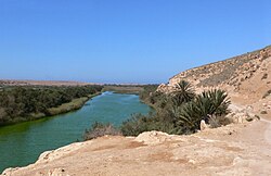
The Massa River (Arabic: واد ماسة) is a river in southern Morocco located in the Sous region. It originates in the Anti-Atlas and flows northwest ending in the Atlantic Ocean at the Souss-Massa National Park.[1][2]
| Massa River | |
|---|---|
 Massa River | |
| Location | |
| Country | Morocco |
| Physical characteristics | |
| Source | |
| • location | Anti-Atlas |
| Mouth | |
• location | Atlantic Ocean |
Yusuf Ibn Tashfin Dam

Constructed in 1972, the Yusuf Ibn Tashfin dam is the main dam on the Massa river.
See also
- Northern bald ibis
- Souss-Massa National Park
- Chtouka Ait Baha
References
- Morocco. Lonely Planet Publications (Firm). 2007.
- Africa: atlas of our changing environment. United Nations Environment Programme. 2008. p. 248.
На других языках
[de] Oued Massa
Der Oued Massa (arabisch وادي ماسة, Zentralatlas-Tamazight ⴰⵙⵉⴼ ⵏ ⵎⴰⵙⵙⴰ) ist ein ca. 120 km langer Küstenfluss in der Region Souss-Massa im Südwesten Marokkos.- [en] Massa River (Morocco)
[es] Río Massa
El río Massa o oued [uadi] Massa es un río de la vertiente atlántica de Marruecos, que baña la comuna rural de Massa en la región de Sus-Masa. Desemboca en el océano Atlántico a unos 80 km al sur de Agadir.Текст в блоке "Читать" взят с сайта "Википедия" и доступен по лицензии Creative Commons Attribution-ShareAlike; в отдельных случаях могут действовать дополнительные условия.
Другой контент может иметь иную лицензию. Перед использованием материалов сайта WikiSort.org внимательно изучите правила лицензирования конкретных элементов наполнения сайта.
Другой контент может иметь иную лицензию. Перед использованием материалов сайта WikiSort.org внимательно изучите правила лицензирования конкретных элементов наполнения сайта.
2019-2025
WikiSort.org - проект по пересортировке и дополнению контента Википедии
WikiSort.org - проект по пересортировке и дополнению контента Википедии