geo.wikisort.org - River
Manor Kill is a river in Schoharie County in the state of New York. It begins northeast of Manorkill and flows westward before flowing into the Schoharie Reservoir southeast of Gilboa, New York. Manor Kill Falls is located on the creek where it passes under Prattsville Road (County Route 39). Since it drains into the Schoharie Reservoir, it is part of the New York City water supply system.
| Manor Kill | |
|---|---|
 Manor Kill Falls | |
 Location of mouth within New York  Manor Kill (the United States) | |
| Location | |
| Country | United States |
| State | New York |
| Region | Central New York |
| County | Schoharie |
| Physical characteristics | |
| Source | |
| • location | Northeast of Manorkill |
| • coordinates | 42°25′00″N 74°17′20″W[1] |
| Mouth | Schoharie Reservoir |
• location | Southeast of Gilboa |
• coordinates | 42°22′49″N 74°25′58″W[1] |
• elevation | 343 feet (105 m)[1] |
| Basin size | 34.4 square miles (89 km2)[2] |
| Basin features | |
| Progression | Manor Kill → Schoharie Reservoir → Schoharie Creek → Mohawk River → Hudson River → Upper New York Bay |
| Tributaries | |
| • right | Bear Kill |
| Waterfalls | Manor Kill Falls |
Hydrology
Manor Kill's watershed receives an average 36.8 inches (930 mm) of precipitation annually. Most of it is concentrated in seasonal events such as summer thunderstorms, remnants of hurricanes later in the year or rain-on-snow events in springtime. This pattern of precipitation, combined with the Manor Kill watershed's slopes and low drainage density, results in flashiness, as the stream and its tributaries rise and fall quickly in response to storm events. The forests that cover much of the watershed tend to mitigate this somewhat.[2]
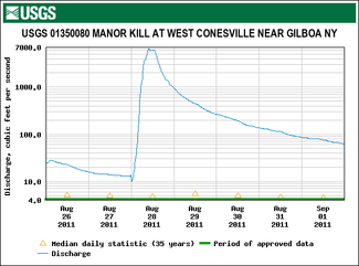
The United States Geological Survey (USGS) maintains one stream gauge along Manor Kill. The station, in service since July 1986, is located 1.2 miles (1.9 km) upstream from the mouth, .5 miles (0.80 km) east of West Conesville, had a maximum discharge of 6,590 cubic feet (187 m3) per second on August 28, 2011, as Hurricane Irene passed through the area. It had a minimum discharge of 1 cubic foot (0.028 m3) per second on August 28–31, 1993, September 1–2, 1993 and September 6–8, 1995.[3]
History
The village of Conesville was previously known as "Stone Bridge" because of the great arched stone bridge that stood where the present bridge crosses the Bearkill. This bridge was washed away in a flood of 1874.
References
- "Manor Kill". usgs.gov. United States Geological Survey. Retrieved November 4, 2021.
- "Hydrology and Flood History" (PDF). Catskill Streams. Retrieved November 5, 2021.
- "USGS 01350080 MANOR KILL AT WEST CONESVILLE NEAR GILBOA NY". United States Geological Survey. Retrieved November 4, 2021.
Другой контент может иметь иную лицензию. Перед использованием материалов сайта WikiSort.org внимательно изучите правила лицензирования конкретных элементов наполнения сайта.
WikiSort.org - проект по пересортировке и дополнению контента Википедии