geo.wikisort.org - River
The Luga (Russian: Луга) is a river in Novgorodsky and Batetsky Districts of Novgorod Oblast and Luzhsky, Volosovsky, Slantsevsky, and Kingiseppsky Districts of Leningrad Oblast of Russia. The river flows into the Luga Bay of the Gulf of Finland. It freezes up in the early December and stays under the ice until early April. The length of the Luga is 353 kilometres (219 mi), and the area of its drainage basin is 13,200 square kilometres (5,100 sq mi).[1] Its main tributary is the Oredezh (right). The towns of Luga and Kingisepp, as well as the urban-type settlement of Tolmachyovo are located on the banks of the Luga. The mouth of the Luga is the site of the Ust-Luga container terminal.
| Luga | |
|---|---|
 The Luga close to the town of Kingisepp | |
 Map of the Luga basin | |
| Location | |
| Country | Russia |
| Physical characteristics | |
| Mouth | Gulf of Finland |
• coordinates | 59°40′38″N 28°18′41″E |
| Length | 353 km (219 mi)[1] |
| Basin size | 13,200 km2 (5,100 sq mi)[1] |
| Discharge | |
| • average | about 100 m3/s (3,500 cu ft/s) |
| Basin features | |
| Tributaries | |
| • left | Saba |
| • right | Oredezh, Yashchera |
The source of the Luga is located in a peat production area in the northwest of Novgorod Oblast, several dozen kilometers northwest of the city of Veliky Novgorod. The river flows south, crosses into Batetsky District, and gradually turns west. A stretch of the Luga serves the border between Novgorod and Leningrad Oblasts. There, the Luga flows northwest, in the town of Luga turns north, accepts the Oredezh from the right, and flows through the urban-type settlement of Tolmachyovo. There, it turns northwest and reaches the border of Luzhsky District. A stretch of the Luga forms the borders between Gatchinsky and Volosovsky, Slantsevsky and Volosovsky, and Kingiseppsky and Volosovsky Districts. In the town of Kingisepp the Luga turns north and subsequently northeast. The mouth of the Luga River is located in the settlement of Ust-Luga.
The drainage basin of the Luga includes large areas in the north of Novgorod Oblast (Novgorodsky and Batetsky Districts), as well as in the southwest of Leningrad Oblast (Gatchinsky, Luzhsky, Volosovsky, Slantsevsky, and Kingiseppsky Districts). In particular, it contains Shum-gora, an archaeological site near the banks of the river in Novgorodsky Oblast, and the Mshinskoye Boloto Zakaznik in Leningrad Oblast, shared between the basins of the Oredezh and the Yashchera.
The Luga below the town of Kingisepp is navigable; however, there is no passenger navigation.
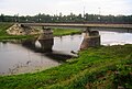 Bridge over the Luga in Kingisepp
 The Luga in Zhelezo, Luzhsky District


References
- Река Луга (in Russian). State Water Register of Russia. Retrieved 4 April 2013.
На других языках
[de] Luga (Fluss)
Die Luga (russisch Луга, finnisch Laukaa, Laukaanjoki, wotisch Laugaz) ist ein Fluss in der Oblast Nowgorod und in der Oblast Leningrad im russischen Föderationskreis Nordwestrussland.- [en] Luga (river)
[it] Luga (fiume)
La Luga (in lingua russa Луга, in finlandese Laukaanjoki, in votico Laugaz) è un fiume della Russia europea nordoccidentale (oblast' di Novgorod e di Leningrado).[ru] Луга (река)
Лу́га (водск. Laugaz, Laukaa jõtši[2]) — река в Ленинградской и Новгородской областях России. Длина реки — 353 км, площадь водосборного бассейна — 13 200 км²[3]. Судоходна на 182 км от устья[4].Другой контент может иметь иную лицензию. Перед использованием материалов сайта WikiSort.org внимательно изучите правила лицензирования конкретных элементов наполнения сайта.
WikiSort.org - проект по пересортировке и дополнению контента Википедии