geo.wikisort.org - River
The Little White River (Lakota: Makhízita Čík'ala;[1] formerly known as the South Fork of the White River) is a tributary of the White River, approximately 234 miles (377 km) long,[2] in south central South Dakota in the United States.
This article needs additional citations for verification. (December 2009) |
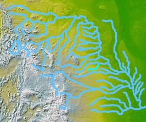
It rises on the Pine Ridge Indian Reservation in southeastern Oglala Lakota County. It flows east past Martin and north of Lacreek National Wildlife Refuge. It flows into the Rosebud Indian Reservation and turns northeast, passing north of Rosebud and west of the town of White River. It joins the White approximately 12 mi (19 km) SSE of Murdo. At White River, the stream measures approximately 150 cubic feet per second (4.2 cubic metres per second).[3]
See also
References
- Ullrich, Jan, ed. (2011). New Lakota Dictionary (2nd ed.). Bloomington, IN: Lakota Language Consortium. p. 995. ISBN 978-0-9761082-9-0. LCCN 2008922508.
- U.S. Geological Survey. National Hydrography Dataset high-resolution flowline data. The National Map Archived 2012-03-29 at the Wayback Machine, accessed March 30, 2011
- "USGS Surface Water data for South Dakota: USGS Surface-Water Annual Statistics".
На других языках
[de] Little White River (White River)
Der Little White River (englisch für „kleiner weißer Fluss“) ist ein 377 km langer rechter Nebenfluss des White River im US-Bundesstaat South Dakota.- [en] Little White River (South Dakota)
Текст в блоке "Читать" взят с сайта "Википедия" и доступен по лицензии Creative Commons Attribution-ShareAlike; в отдельных случаях могут действовать дополнительные условия.
Другой контент может иметь иную лицензию. Перед использованием материалов сайта WikiSort.org внимательно изучите правила лицензирования конкретных элементов наполнения сайта.
Другой контент может иметь иную лицензию. Перед использованием материалов сайта WikiSort.org внимательно изучите правила лицензирования конкретных элементов наполнения сайта.
2019-2025
WikiSort.org - проект по пересортировке и дополнению контента Википедии
WikiSort.org - проект по пересортировке и дополнению контента Википедии