geo.wikisort.org - River
The Little Auglaize River is a 47.0-mile-long (75.6 km)[1] tributary of the Auglaize River in northwest Ohio in the United States. It drains a primarily rural farming area in the watershed of Lake Erie.
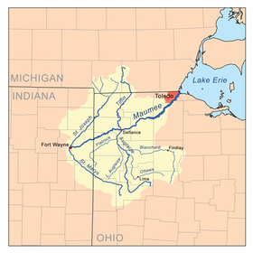
It rises in southern Van Wert County, approximately 10 miles (16 km) south of Van Wert. It flows northeast past Middle Point. Near Ottoville in western Putnam County it turns north-northwest for its lower 10 miles (16 km) and joins the Auglaize from the south near Melrose in eastern Paulding County.
See also
References
- U.S. Geological Survey. National Hydrography Dataset high-resolution flowline data. The National Map Archived 2012-03-29 at the Wayback Machine, accessed May 19, 2011
This Paulding County, Ohio state location article is a stub. You can help Wikipedia by expanding it. |
This Putnam County, Ohio state location article is a stub. You can help Wikipedia by expanding it. |
This Van Wert County, Ohio state location article is a stub. You can help Wikipedia by expanding it. |
На других языках
[de] Little Auglaize River
Der Little Auglaize River ist ein 48 km langer linker Nebenfluss des Auglaize River im Nordwesten des US-Bundesstaats Ohio und gehört zum Flusssystem des Sankt-Lorenz-Stroms.- [en] Little Auglaize River
Другой контент может иметь иную лицензию. Перед использованием материалов сайта WikiSort.org внимательно изучите правила лицензирования конкретных элементов наполнения сайта.
WikiSort.org - проект по пересортировке и дополнению контента Википедии