geo.wikisort.org - River
This is a list of crossings of the River Avon in England (including bridges, tunnels, ferries and fords), in order from its source in Northamptonshire, through or adjoining the counties of Leicestershire, Northamptonshire, Warwickshire, and Worcestershire, to its confluence with the River Severn at Tewkesbury in Gloucestershire.
Crossings
| Status | Criteria[1] |
|---|---|
SM |
Scheduled monument. Nationally important archaeological bridge. |
| I | Grade I listed. Bridge of exceptional interest, sometimes considered to be internationally important |
| II* | Grade II* listed. Particularly important bridge of more than special interest |
| II | Grade II listed. Bridge of national importance and special interest |
In order, moving downstream:
This list is incomplete; you can help by adding missing items. (May 2022) |
| Crossing | Date | Coordinates | Heritage status |
Locality | Notes | Image |
|---|---|---|---|---|---|---|
| Source of the River Avon | n/a | 52.3975°N 0.9887°W | n/a | Naseby, Northamptonshire | Included for completeness |
|
| Dow Bridge | 1838 | 52.396599°N 1.202795°W | II | Newton | Disused. Incorporates parts of a circa 1776 bridge which it replaced. Marks the tri-point of Northamptonshire, Leicestershire and Warwickshire.[2][3][4] |  |
| Dow bridge (new) | 1930s | 52.39655°N 1.20297°W | Newton | Replaced the earlier Dow Bridge. Carries the A5. | ||
| Midland Counties Railway Viaduct | 1840 | 52.384531°N 1.263976°W | II | Rugby | Disused railway viaduct; now pedestrians only.[5][6] |  |
| Bretford Bridge | 18th century | 52.389186°N 1.370108°W | II | Bretford, Brandon and Bretford | Stone road bridge of 13th century origin, largely rebuilt to the original design in the 18th century. Carries the A428 road over one semi-circular and 4 pointed arches.[7][8] |  |
| Brandon Viaduct (or Avon Viaduct) | 1838 | 52.38126°N 1.39964°W | II | Brandon and Bretford | Carries the Birmingham Loop of the West Coast Main Line; built as part of part of the London and Birmingham Railway.[9] |  |
| Stare Bridge | Late 15th century | 52.34000°N 1.51777°W | II* | Stoneleigh | 9 arches.[10] |  |
| Chesford Bridge (A452) | 52.325969°N 1.556909°W | Blackdown | Vehicle and pedestrian. Stone, five arches. | |||
| Hill Wootton Road | 52.319289°N 1.546806°W | Blackdown | Vehicle and pedestrian. | |||
| Old Milverton rail viaduct | 52.308954°N 1.561267°W | Old Milverton | Multiple arch brick rail viaduct | |||
| Sir Anthony Eden Way | 2007 | 52.291122°N 1.559741°W | Leamington Spa and Warwick | Road bridge |  | |
| Portobello Bridge | 1831 | 52.289216°N 1.560064°W | II | Leamington Spa and Warwick | Three span stone bridge.[11] |  |
| Grand Union Canal | 1800 | 52.286378°N 1.560452°W | Leamington Spa | Aquaduct |  | |
| Chiltern Main Line | 1852 (original) | 52.284757°N 1.563156°W | Warwick | Metal railway viaduct |  | |
| Charter Bridge | 1996 | 52.282894°N 1.571323°W | Warwick | Metal pedestrian and cycle bridge |  | |
| Castle Bridge | 1793 | 52.279629°N 1.579537°W | II* | Warwick | Replaced Old Castle Bridge.[12][13] |  |
| Old Castle Bridge | 1208 or before | 52.279214°N 1.583308°W | II* | Warwick | Destroyed 1795. Impassible ruins only remain.[14][15] |  |
| [Unnamed bridge] | 52.279214°N 1.583308°W | Warwick | Footbridge only, wooden, on private land. Part of the Warwick Castle estate |  | ||
| Leafield Bridge | 1772 | 52.26484°N 1.59195°W | II | Warwick | A stone bridge designed by Robert Mylne.[16] |  |
| M40 | 52.2569°N 1.5980°W | A pair of adjacent bridges, one for each carriageway. | ||||
| Barford | 18th century | 52.2463°N 1.6092°W | II | Barford | Five sandstone arches.[17] |  |
| Barford Bypass | 52.2462°N 1.6105°W | Barford | ||||
| Hampton Lucy Bridge | 1829 | 52.2121°N 1.62442°W | II | Hampton Lucy | Cast iron.[18] | 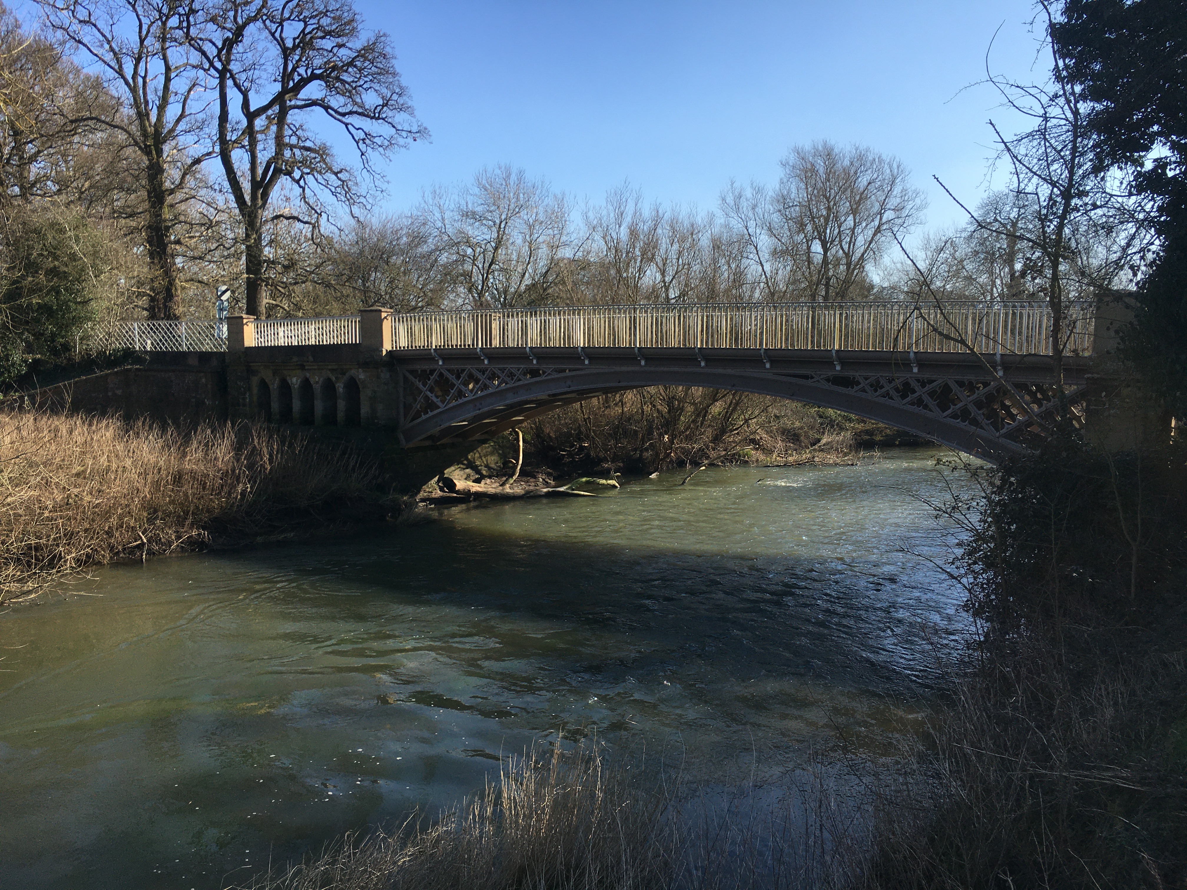 |
| [Unnamed] | 52.20294°N 1.68349°W | Avon Caravan Park, Tiddington | ||||
| Clopton Bridge | 1484 (circa) | 52.19155°N 1.700311°W | SM |
Stratford-upon-Avon | Replaced a timber bridge first mentioned in 1235.[19] |  |
| Tramway Bridge | 1823 | 52.191049°N 1.701417°W | II | Stratford-upon-Avon | Eight brick arches which carried a horse tramway, now pedestrian only.[20] |  |
| Stratford-upon-Avon chain ferry | 1937 | 52.189035°N 1.705475°W | Stratford-upon-Avon | Manually operated chain ferry.[21] |  | |
| Lucy's Mill bridge | 52.18380°N 1.70811°W | Stratford-upon-Avon | footbridge |  | ||
| Seven Meadows Road bridge | 52.18368°N 1.70826°W | Stratford-upon-Avon | A4390 |  | ||
| Stratford Greenway | 52.17767°N 1.72654°W | Stratford-upon-Avon | Former railway |  | ||
| Binton Bridge | 1783 (circa) | 52.17561°N 1.78955°W | II | Welford-on-Avon | Passes over an island in the river on seven arches of Blue Lias.[22] |  |
| Bidford Bridge | early 15th century | 52.16402°N 1.85666°W | SM |
Bidford-on-Avon, Warwickshire | Eight arch bridge of limestone.[23] | 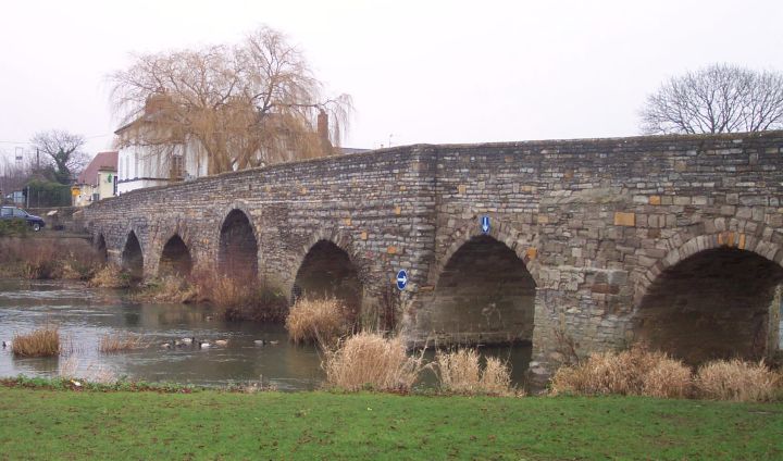 |
| George Billington Lock footbridge | 52.12280°N 1.90570°W | |||||
| Simon de Montford Bridge | 52.1059°N 1.9293°W | near Greenhill, Worcestershire | Carries A46.[24] |  | ||
| Even Railway Bridge | 52.0972°N 1.9357°W | Evesham | Cotswold Line (railway) |  | ||
| Workman Bridge | 1856 | 52.091492°N 1.943074°W | II | Evesham | A stone bridge of three arches.[25] |  |
| Abbey Bridge | 52.08636°N 1.95190°W | Evesham |  | |||
| Cotswold Line (2) | 52.10081°N 1.95451°W | Evesham | Railway |  | ||
| Evesham Golf Course Railway Bridge | 52.11833°N 2.00606°W | Fladbury | Cotswold Line (railway) | |||
| Jubilee Bridge | 1935 | 52.108647°N 2.000848°W | Fladbury | Replaced an earlier bridge, named for the Golden Jubilee of Queen Victoria |  | |
| [Unnamed pipeline] | 52.10635°N 2.03073°W | Fladbury | No pedestrian access |  | ||
| Pershore Old Bridge | probably late C15 | 52.104551°N 2.070998°W | SM |
Pershore | Now pedestrian/ cycle only. Five span bridge of sandstone with a red brick parapet.[26] |  |
| Pershore Bridge | 52.104200°N 2.071316°W | Pershore | Replaced Pershore Old Bridge |  | ||
| Nafford Lock | 52.0751°N 2.0885°W | Chain of three bridges, via island; pedestrians only |  | |||
| Eckington Bridge | 1720 (circa) | 52.0793°N 2.1149°W | II* | Eckington, Worcestershire | Carries the B4080 road. First bridge at the site was built in 1440, replacing an earlier ferry.[27][28][29] |  |
| B4080 | 52.0793°N 2.1150°W | |||||
| Defford Railway Bridge | 52.0805°N 2.1220°W | Birmingham and Gloucester Railway[30] |  | |||
| Strensham Lock | 52.06034°N 2.12369°W | Eckington, Worcestershire | Chain of small bridges and islands |  | ||
| M5 | 52.03063°N 2.12547°W | A pair of parallel bridges, one for each carriageway. |  | |||
| Tewkesbury Quay | 51.99887°N 2.15476°W | Tewkesbury, Gloucestershire | ||||
| Tewkesbury and Malvern Railway bridge | 51.99888°N 2.15474°W | Demolished and replaced with a footbridge |  | |||
| King John's Bridge | 1190 (circa); restructured 1824 | 51.9978°N 2.1567°W | II* | Tewkesbury | Crosses the bifurcated Avon, twice, via an island, on five sandstone arches. Carries the A38, Mythe Road.[31] |  |
| Confluence with River Severn | n/a | 51.9964°N 2.1634°W | n/a | Tewkesbury | Included for completeness |
References
Wikimedia Commons has media related to Bridges across the River Avon, Warwickshire.
- Listed Buildings, English Heritage, archived from the original on 9 December 2012
- "Dow Bridge". Catthorpe.org. Retrieved 14 March 2020.
- "Dow Bridge". Our Warwickshire. Retrieved 14 March 2020.
- "Dow Bridge". Historic England. Retrieved 14 March 2020.
- "Rugby Viaduct". Forgotten Relics. Retrieved 14 November 2018.
- "Railway Viaduct A Grade II Listed Building in Rugby, Warwickshire". British Listed Buildings. Retrieved 14 November 2018.
- Historic England. "Details from listed building database (1365087)". National Heritage List for England. Retrieved 17 March 2015.
- "BRETFORD BRIDGE". Our Warwickshire. Retrieved 17 August 2020.
- Historic England. "Avon Viaduct (1034898)". National Heritage List for England. Retrieved 22 May 2022.
- Historic England. "Avon Viaduct (1106390)". National Heritage List for England. Retrieved 22 May 2022.
- Historic England. "Portobello Bridge (1271475)". National Heritage List for England. Retrieved 22 May 2022.
- "Castle Bridge A Grade II* Listed Building in Warwick, Warwickshire". British Listed Buildings. Retrieved 1 October 2020.
- "Castle Bridge, Warwick". Our Warwickshire. Archived from the original on 12 August 2020. Retrieved 1 October 2020.
- "The borough of Warwick: Introduction, the medieval town". British History Online. University of London. 1969. Retrieved 6 October 2016.
- Historic England. "Remains of Old Castle Bridge (1035499)". National Heritage List for England. Retrieved 6 October 2016.
- Historic England. "Leafield Bridge (1035509)". National Heritage List for England. Retrieved 23 May 2022.
- Historic England. "Barford Bridge (1319939)". National Heritage List for England. Retrieved 23 May 2022.
- Historic England. "Bridge Over River Avon, Hampton Lucy (1382105)". National Heritage List for England. Retrieved 1 March 2021.
- "A History of the County of Warwick: Volume 3, Barlichway Hundred The borough of Stratford-upon-Avon: Introduction and architectural description". British History Online. Retrieved 18 February 2022.
- Historic England. "Tramway Bridge (1187828)". National Heritage List for England. Retrieved 23 May 2022.
- "Help mark 80 years of Stratford's chain ferry". Stratford Herald. 4 June 2017. Retrieved 24 May 2022.
- Historic England. "Binton Bridge (1382796)". National Heritage List for England. Retrieved 23 May 2022.
- Historic England. "Bidford Bridge (1355318)". National Heritage List for England. Retrieved 23 May 2022.
- "Simon de Montford Bridge". CanalplanAC. Retrieved 22 May 2022.
- Historic England. "Workman Bridge (1156175)". National Heritage List for England. Retrieved 23 May 2022.
- Historic England. "Pershore Bridge (1005266)". National Heritage List for England. Retrieved 23 May 2022.
- Historic England. "Eckington Bridge (1005264)". National Heritage List for England. Retrieved 5 April 2015.
- Historic England. "Eckington Bridge (1116724)". National Heritage List for England. Retrieved 5 April 2015.
- "Eckington Bridge". historicengland.org.uk. English Heritage. Retrieved 10 August 2014.
- "Defford Railway Bridge". CanalplanAC. Retrieved 22 May 2022.
- Historic England. "King John's Bridge (1201287)". National Heritage List for England. Retrieved 23 May 2022.
Текст в блоке "Читать" взят с сайта "Википедия" и доступен по лицензии Creative Commons Attribution-ShareAlike; в отдельных случаях могут действовать дополнительные условия.
Другой контент может иметь иную лицензию. Перед использованием материалов сайта WikiSort.org внимательно изучите правила лицензирования конкретных элементов наполнения сайта.
Другой контент может иметь иную лицензию. Перед использованием материалов сайта WikiSort.org внимательно изучите правила лицензирования конкретных элементов наполнения сайта.
2019-2025
WikiSort.org - проект по пересортировке и дополнению контента Википедии
WikiSort.org - проект по пересортировке и дополнению контента Википедии