geo.wikisort.org - River
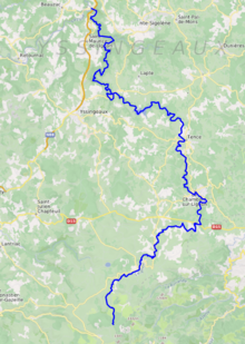
The Lignon du Velay (French pronunciation: [liɲɔ̃ dy vəlɛ], literally Lignon of the Velay) is an 85.1-kilometre (52.9 mi) long river in the Ardèche and Haute-Loire departments, south-central France.[1] Its source is near Chaudeyrolles. It flows generally north. It is a right tributary of the Loire, into which it flows at Pont de Lignon, a hamlet in Monistrol-sur-Loire.
| Lignon du Velay | |
|---|---|
 | |
 | |
| Location | |
| Country | France |
| Physical characteristics | |
| Source | |
| • location | Chaudeyrolles |
| • coordinates | 44°55′23″N 04°10′42″E |
| • elevation | 1,440 m (4,720 ft) |
| Mouth | |
• location | Loire |
• coordinates | 45°15′31″N 04°08′42″E |
• elevation | 460 m (1,510 ft) |
| Length | 85.1 km (52.9 mi) |
| Basin size | 661.3 km2 (255.3 sq mi) |
| Discharge | |
| • average | 9.8 m3/s (350 cu ft/s) |
| Basin features | |
| Progression | Loire→ Atlantic Ocean |
Departments and communes along its course
This list is ordered from source to mouth:
- Haute-Loire: Chaudeyrolles, Saint-Front, Fay-sur-Lignon, Les Vastres, Mazet-Saint-Voy
- Ardèche: Mars
- Haute-Loire: Le Chambon-sur-Lignon, Saint-Jeures, Tence, Chenereilles, Lapte, Yssingeaux, Grazac, Les Villettes, Saint-Maurice-de-Lignon, Monistrol-sur-Loire
References
This Ardèche geographical article is a stub. You can help Wikipedia by expanding it. |
This Haute-Loire geographical article is a stub. You can help Wikipedia by expanding it. |
На других языках
[de] Lignon du Velay
Der Lignon du Velay ist ein Fluss in Frankreich, der im Département Haute-Loire in der Region Auvergne-Rhône-Alpes verläuft. Er entspringt nordwestlich des Mont Mézenc, an der Gemeindegrenze von Chaudeyrolles und Saint-Front. Der Lignon de Velay entwässert generell Richtung Nord, durchquert die Landschaft des Velay und mündet nach rund 85[2] Kilometern beim Ort Pont de Lignon, im Gemeindegebiet von Saint-Maurice-de-Lignon, als rechter Nebenfluss in die Loire.- [en] Lignon du Velay
Текст в блоке "Читать" взят с сайта "Википедия" и доступен по лицензии Creative Commons Attribution-ShareAlike; в отдельных случаях могут действовать дополнительные условия.
Другой контент может иметь иную лицензию. Перед использованием материалов сайта WikiSort.org внимательно изучите правила лицензирования конкретных элементов наполнения сайта.
Другой контент может иметь иную лицензию. Перед использованием материалов сайта WikiSort.org внимательно изучите правила лицензирования конкретных элементов наполнения сайта.
2019-2026
WikiSort.org - проект по пересортировке и дополнению контента Википедии
WikiSort.org - проект по пересортировке и дополнению контента Википедии