geo.wikisort.org - River
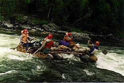
The Kantegir (Russian: Кантегир) is a left tributary of the Yenisey in Siberia, Russia. It begins on the northern slopes of the ridge Saylyg-Khem-Taiga, the Republic of Tyva. It is 209 kilometres (130 mi) long, and has a drainage basin of 5,400 square kilometres (2,100 sq mi).[1]
| Kantegir | |
|---|---|
 | |
| Location | |
| Country | Russia |
| Physical characteristics | |
| Mouth | Yenisey |
• coordinates | 52.7258°N 91.3173°E |
| Length | 209 km (130 mi) |
| Basin size | 5,400 km2 (2,100 sq mi) |
| Basin features | |
| Progression | Yenisey→ Kara Sea |
Kantegir is a river with an average fall of 4.5 m/km, it is one of the most beautiful rivers of the Western Sayan mountains. It flows in virtually unpopulated terrain in the area of black coniferous taiga. Scenic mountain top Kantegira heavily indented tributaries and dry padyami with signs of spring watercourses. Taiga covers the rocky shore of the river, climbing to the tops of mountains rising to 100–150 m above the bottom of the valley Kantegirskoy. Valley Kantegira throughout clenched mountains to 100–200 m, the valley slopes are steep, with rocky outcrops of granite, shale, sandstone.[2]
References
- "Река Кантегир (Хантер, Кантейгир, Хан-Тен-Гир) in the State Water Register of Russia". textual.ru (in Russian).
- "Сплав по реке Кантегир". www.fantasyway.ru. Retrieved 2016-06-17.
На других языках
[de] Kantegir
Der Kantegir (russisch Кантеги́р) ist ein linker Nebenfluss des Jenissei in den Republiken Tuwa und Chakassien sowie in der Region Krasnojarsk im Süden Sibiriens.- [en] Kantegir
[it] Kantegir
Il Kantegir (in russo: Кантегир?; in chakasso Хан-Тигір, Chan-Tigir o Han-Tigir, che significa "mondo superiore"[1]) è un fiume nella parte asiatica della Russia, affluente di sinistra dello Enisej. Scorre nella Siberia meridionale, nella Repubblica di Tuva, nella Chakassia e (per la maggior parte) nel Territorio di Krasnojarsk, attraversando i rispettivi Sut-Chol'skij kožuun, Bejskij rajon e Šušenskij rajon.[ru] Кантегир
Кантеги́р (хак. Хан-Тигір) — сибирская река в Тыве, Хакасии и (большей частью) Красноярском крае, левый приток Енисея. Впадает в Саяно-Шушенское водохранилище. Длина реки — 209 км[2]. Площадь водосборного бассейна — 5400 км²[2].Другой контент может иметь иную лицензию. Перед использованием материалов сайта WikiSort.org внимательно изучите правила лицензирования конкретных элементов наполнения сайта.
WikiSort.org - проект по пересортировке и дополнению контента Википедии