geo.wikisort.org - River
The Kanawha River (/kəˈnɔːə/ kə-NAW-ə) is a tributary of the Ohio River, approximately 97 mi (156 km) long, in the U.S. state of West Virginia. The largest inland waterway in West Virginia, its valley has been a significant industrial region of the state since early in the 19th century.
| Kanawha River | |
|---|---|
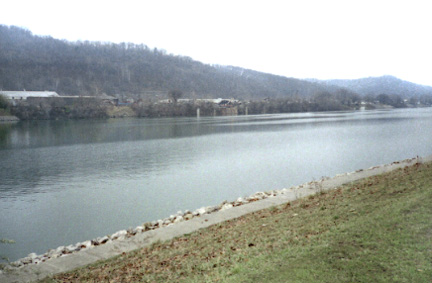 Kanawha River at St. Albans, West Virginia | |
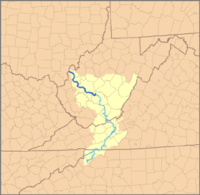 Map of the Kanawha River and its tributary the New River, with the Kanawha River highlighted in darker blue. | |
| Location | |
| Country | United States |
| State | West Virginia |
| Counties | Fayette, Kanawha, Putnam, Mason |
| Physical characteristics | |
| Source | New River |
| • location | Ashe County, NC |
| • coordinates | 36°32′45″N 81°21′09″W |
| • elevation | 2,546 ft (776 m) |
| 2nd source | Gauley River |
| • location | Three Forks of Gauley, Pocahontas County, WV |
| • coordinates | 38°24′33″N 80°14′17″W |
| • elevation | 2,917 ft (889 m) |
| Source confluence | |
| • location | Gauley Bridge, WV |
| • coordinates | 38°09′42″N 81°11′47″W |
| • elevation | 653 ft (199 m) |
| Mouth | Ohio River[1] |
• location | Point Pleasant, WV |
• coordinates | 38°50′16″N 82°08′34″W |
• elevation | 538 ft (164 m) |
| Length | 97 mi (156 km) |
| Basin size | 12,236 sq mi (31,690 km2) |
| Discharge | |
| • location | Charleston, 56.8 mi (91.4 km) from the mouth[2][3] |
| • average | 15,240 cu ft/s (432 m3/s) |
| • minimum | 1,100 cu ft/s (31 m3/s) |
| • maximum | 216,000 cu ft/s (6,100 m3/s) |
| Basin features | |
| Progression | Kanawha River → Ohio River → Mississippi River → Gulf of Mexico |
| Tributaries | |
| • left | Coal River |
| • right | Elk River, Pocatalico River |
It is formed at the town of Gauley Bridge in northwestern Fayette County, approximately 35 mi (56 km) SE of Charleston, by the confluence of the New and Gauley rivers. It flows generally northwest, in a winding course on the unglaciated Allegheny Plateau, through Fayette, Kanawha, Putnam, and Mason counties, past the cities of Charleston and St. Albans, and numerous smaller communities. It joins the Ohio at Point Pleasant.
Paleo-Indians, the earliest indigenous peoples, lived in the valley and the heights by 10,000 BC as evidenced by archaeological artifacts such as Clovis points. A succession of prehistoric cultures developed, with the Adena culture beginning the construction of numerous skilled earthwork mounds and enclosures more than 2000 years ago. Some of the villages of the Fort Ancient culture survived into the times of European contact.
The area was a place of competition among historical American Indian nations. Invading from their base in present-day New York, the Iroquois drove out or conquered Fort Ancient culture peoples, as well as such tribes as the Huron and Conoy. By right of conquest, the Iroquois, Lenape (Delaware), and Shawnee reserved the area as a hunting ground. They resisted European-American settlement during the colonial years. Eventually the settlers took over by right of conquest.
The river valley contains significant deposits of coal and natural gas. In colonial times, the wildly fluctuating level of the river prevented its use for transportation. The removal of boulders and snags on the lower river in the 1840s allowed navigation, which was extended upriver after the construction of locks and dams starting in 1875. The river is now navigable to Deepwater, an unincorporated community about 20 miles (32 km) upriver from Charleston. A thriving chemical industry along its banks provides a significant part of the local economy.
Tributaries
In addition to the New and Gauley River headwaters, the Kanawha is joined at Charleston by the Elk River, at St. Albans by the Coal River, and at Poca by the Pocatalico River.
Name
![Winfield Lock and Dam on the Kanawha River at Winfield, West Virginia, 31 miles upriver from the mouth at Point Pleasant. Map:[4]](http://upload.wikimedia.org/wikipedia/commons/2/26/USACE_Winfield_Lock_West_Virginia.jpg)
"Ka(ih)nawha" derives from the region's Iroquoian dialects meaning "water way" or "canoe way" implying the metaphor, "transport way", in the local language.[5] The glottal consonant of the "ih" (stream or river, local Iroquois) dropped out as settlers and homesteaders arrived.[6]
The river has also had historical alternate names, alternate spellings and misspellings including Wood's River for Colonel Abraham Wood, an English explorer from Virginia, the first European known to have explored the river in the mid 17th century.[7]
History
Archaeological artifacts, such as Clovis points and later projectiles, indicate prehistoric indigenous peoples living in the area from the 12,500 BC era. Peoples of later cultures continued to live along the valley and heights. Those of the Adena culture built at least 50 earthwork mounds and 10 enclosures in the area between Charleston and Dunbar, as identified by an 1882 to 1884 survey by the Bureau of Ethnology (later part of the Smithsonian Institution). Three of their mounds survive in the valley, including Criel Mound at present-day South Charleston, West Virginia. Evidence has been found of the Fort Ancient culture peoples, who had villages that survived to the time of European contact, such as Buffalo and Marmet. They were driven out by Iroquois from present-day New York.
According to French missionary reports, by the late 16th century, several thousand Huron, originally of the Great Lakes region, lived in central West Virginia. They were partially exterminated and their remnant driven out in the 17th century by the Iroquois' invading from western present-day New York. Other accounts note that the tribe known as Conois, Conoy, Canawesee, or Kanawha were conquered or driven out by the large Seneca tribe, one of the Iroquois Confederacy, as the Seneca boasted to Virginia colonial officials in 1744. The Iroquois and other tribes, such as the Shawnee and Delaware, maintained central West Virginia as a hunting ground. It was essentially unpopulated when the English and Europeans began to move into the area.[8]
The first white person to travel through Virginia all the way to the Ohio River (other than as a prisoner of the Indians) was Matthew Arbuckle, Sr., who traversed the length of the Kanawha River valley arriving at (what would later be called) Point Pleasant around 1764. In April 1774, Captain Hanson was one of an expedition: "18th. We surveyed 2,000 acres (8.1 km2) of Land for Col. Washington, bordered by Coal River & the Canawagh..."[9] This area is the lower area of today's St. Albans, West Virginia. After the Treaty of Fort Stanwix, "The Kanawhas had gone from the upper tributaries of the river which bears their name, to join their kinsmen, the Iroquois in New York; the Shawnee had abandoned the Indian Old Fields of the valley of the South Branch of the Potomac; the Delaware were gone from the Monongahela; the Cherokee who claimed all the region between the Great Kanawha and Big Sandy, had never occupied it." quoting Virgil A. Lewis (1887), corresponding member of the Virginia Historical Society.[10] The river's name changes to the Kanawha River at the Kanawha Falls. The Treaty of Big Tree between the Seneca nation and the United States established ten reservations. This formal treaty was signed on September 15, 1797.[11] Lewis was granted a large tract of land near the mouth of the Great Kanawha River in the late 18th century.
The Little Kanawha and the Great Kanawha rivers, the two largest in the state, were named for the American Indian tribe that lived in the area prior to European settlement in the 18th century. Under pressure from the Iroquois, most of the Conoy/Kanawha had migrated to present-day Virginia by 1634, where they had settled on the west side of the Chesapeake Bay and below the Potomac River. They were also known to the colonists there as the Piscataway. They later migrated north to Pennsylvania, to submit and seek protection with the Susquehannock and Iroquois. The spelling of the Indian tribe varied at the time, from Conoys to Conois to Kanawha. The latter spelling was used and has gained acceptance over time.[8]

Crossings
List of cities and towns along the Kanawha River

See also
- Kanawha Valley people
- Adena culture
- List of West Virginia rivers
- Little Kanawha River, an unrelated Ohio River tributary also in West Virginia
- Kanawha River Valley AVA, an American Viticultural Area
- USS Kanawha (AO-1)—a fleet oiler built in 1914.
- Kanawha a steam-powered luxury yacht built in 1899 and owned by Henry Huttleston Rogers, developer of coal and railroad properties in southern West Virginia, including the Virginian Railway
- The USAT General Frank M. Coxe built in Charleston, served as an Army transport vessel and now preserved as a floating restaurant.
- West Virginia Waterways
- Charleston, West Virginia metropolitan area, often called the "Kanawha Valley" by locals
- Port of Huntington Tri-State
References
- U.S. Geological Survey Geographic Names Information System: Kanawha River
- accessed 2011-06-16
- United States Geological Survey; USGS 03193000 KANAWHA RIVER AT KANAWHA FALLS, WV; retrieved April 19, 2008.
- layer= - Google Maps. Maps.google.com (1970-01-01). Retrieved on 2013-08-09.
- Kanien’kehá:ka Onkwawén:na Raotitióhkwa Language, Kawhinawha'kae montreal, "Kentá:ke had been a Jesuit residence that receive Mohawk from the south, the newly established settlement of Kahnawà:ke was from its beginning an Iroquois community." for more information on the Kanien’kehá:ka www.kahnawakelonghouse.com/index.php?mid=2
- Kahnawáʼkye in Tuscarora (Iroquois) means "waterway", "kye" is augmentive suffix.
Kaniatarowanenneh means "big waterway" in Mohawk (Iroquois).
Lachler, McElwain, and Burke http://www.mingolanguage.org/
Mingo (Iroquois) etymology about boating: kaháwa' noun means boat. kényua'. This switch-interactive verb means to row a boat or more to ferry someone across a stretch of water. It belongs to the semantic fields the sea and transportation. Etymology kényua' -NYU- Verb Root. Grammatical Info Base -nyu-.Stem Class LX. Conjugation Class XX. kényua' "I row boats". kaháwa', (boat) grammatical info base -haw- Stem Class C, Prefix Class Agent, Linker Vowel ö. Note that the -h- at the beginning of this base is strong, and so does not drop out when it would come between two vowels. Varies with kahôwö'. Possessed Form akháwa' my boat. Plural Form kahawa'shö'ö boats. káhu' means "this way" or in this direction. See also Mohawk language (Dialects) -
According to the Geographic Names Information System, the Kanawha River has also been known as:
- Big Connawas River
- Big Kanawha River
- Canawha
- Canhawa River
- Chinidashhichetha
- Chinodahichetha River
- Chinodashichetha
- Chinondaista
- Great Canawha River
- Great Kanawha River
- Great Kanhawa River
- Great Kanhaway River
- Great Kehhawa River
- Great Kenhawa River
- Great Kenhaway River
- Great Konhaway River
- Great Konhawayriver
- Kanahaway River
- Kanawa River
- Kanawah River
- Kanaway River
- Kanawhy River
- Kanhaway River
- Kannawha River
- Keanawha River
- Kenhaway River
- Keninsheka
- Kinhaway River
- Kunhaway River
- Le-we-ke-o-mi
- Mon-don-ga-cha-te
- New River
- Pi-que-me-ta-mi
- Pique-me-ta-nei
- Woods River
- Dilger, Robert J.; Marshall, James (21 Feb 2002). "Kanawha County History". Institute for Public Affairs, West Virginia University. Archived from the original on 2010-06-16. Retrieved 31 Oct 2009.
- From Documentary History of Dunmore's War, edited by Reuben Gold Thwaites and Louise Phelps Kellogg, Madison, Wisconsin Historical Society, 1905 pp. 110-17. For text of the Journal see www.wvculture.org/HISTORY/dunmore/hanson.html
- History of West Virginia In Two Parts, Philadelphia. Hubbard Brothers, Publishers. 1889.
West Virginia State Historian/Archivist, Virgil A. Lewis, 1905 - 1912 (died while in the position) from Mason County – see WV Bluebook reference MC descriptions 1916–1920. (11/1/09) - "A History of the Treaty of Big Tree, and Robert Morris" by Livingston County Historical Society, O. Burnell Print, 1897
Further reading
- Arthur Benke & Colbert Cushing, Rivers of North America, Elsevier Academic Press, 2005 ISBN 0-12-088253-1
- Atkinson, George W. 1876. History of Kanawha County, From. . . 1789 Until the Present Time, Charleston: West Virginia Journal Office.
- Braley, Dean (1993). The Shaman's Story, West Virginia Petroglyphs. St. Albans. ISBN 0-9638377-0-2.
- Dayton, Ruth Woods. 1947. Pioneers and Their Homes on Upper Kanawha, Charleston: West Virginia Publishing Company.
- Dickens, Roy S. Jr.; Mckinley, James L. (1979). Frontiers in the Soil: The Archaeology of Georgia. LaGrange, Georgia: Frontiers Publishing Company.
- Laidley, W. S. 1911. History of Charleston and Kanawha County, West Virginia, Chicago: Richmond-Arnold Publishing Company
- Lewis, Thomas M. N. and Madeline Kneberg. 1958. Tribes That Slumber, Knoxville, TN: The University of Tennessee Press
- McMichael, Edward V. 1968. Introduction to West Virginia Archeology, Morgantown, WVA: West Virginia Geological and Economic Survey
- Nabokov, Peter; Easton, Robert (1989). Native American Architecture. New York: Oxford University Press. ISBN 0-19-503781-2.
- Potter, Eloise F.; Funderburg, John B. (1986). Native Americans: The People and How They Lived. Raleigh, North Carolina: North Carolina State Museum of Natural Sciences. ISBN 0-917134-10-9.
- Rhodes, Captain Rick, The Ohio River in American History and Voyaging on Today's River. Heron Island Guides, 2007, ISBN 978-0-9665866-3-3
- Thomas, Cyrus. 1894. Report on the Mound Explorations of the Bureau of Ethnology. Smithsonian Institution Press
- Wavra, Grace (1990). The First Families of West Virginia. Huntington: University Editions, Inc. ISBN 1-56002-007-5.
- Weatherford, Jack M. (1988). Indian Givers. New York: Crown Publishers, Inc. ISBN 0-449-90496-2.
Authority control | |
|---|---|
| General |
|
| National libraries | |
| Other | |
На других языках
[de] Kanawha River
Der Kanawha River ist ein 156 km langer, linker Nebenfluss des Ohio River in West Virginia.- [en] Kanawha River
[es] Río Kanawha
El río Kanawha (en inglés: 'Kanawha River'), es un afluente del Ohio, por su margen izquierda, que discurre íntegramente por el estado de Virginia Occidental, en Estados Unidos. El río Kanawha tiene una longitud de 156 km, pero con una de sus fuentes, el río New, de 515 km, llega hasta los 671 km.[ru] Канова (река)
Канова (англ. Kanawha River) — река на западе центральной части штата Западная Виргиния, США. Левый приток реки Огайо. Длина составляет 156 км; площадь бассейна — 31 691 км². Средний расход воды — 432 м³/с.[источник не указан 1990 дней]Другой контент может иметь иную лицензию. Перед использованием материалов сайта WikiSort.org внимательно изучите правила лицензирования конкретных элементов наполнения сайта.
WikiSort.org - проект по пересортировке и дополнению контента Википедии