geo.wikisort.org - River
The Irkut (Russian: Ирку́т; Buryat and Mongolian: Эрхүү гол, Erhüü gol) is a river in the Buryat Republic and Irkutsk Oblast of Russia. It is a left tributary of the Angara. It flows out of lake Ilchir which is situated 50 km away from the highest peak of the Eastern Sayan Mountains, Munku-Sardyk. The length of the river is 488 kilometers (303 mi). The area of its basin is 15,000 square kilometers (5,800 sq mi).[1] The Irkut freezes up in late October or mid-November and stays icebound until late April or early May. The city of Irkutsk is located at the mouth of the Irkut on the Angara.[2]
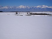 Irkut near the village of Zaktuy in the Tunkinsky National Park
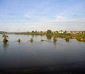 The Irkut as seen from a train window (near its confluence with the Angara)
 The Irkut in Buryatia (early February)


 | This article needs additional citations for verification. (June 2019) |
| Irkut | |
|---|---|
 | |
| Location | |
| Country | Russia |
| Physical characteristics | |
| Mouth | Angara |
• coordinates | 52.2907°N 104.2754°E |
| Length | 488 km (303 mi) |
| Basin size | 15,000 km2 (5,800 sq mi) |
| Basin features | |
| Progression | Angara→ Yenisey→ Kara Sea |
References
 |
Wikimedia Commons has media related to Irkut River. |
- "Река Иркут in the State Water Register of Russia". textual.ru (in Russian).
- Curtin, J. (1910). A Journey In Southern Siberia: The Mongols, Their Religion and Their Myths. Library of Alexandria. London. p. pt21. ISBN 978-1-4655-2060-9. Retrieved June 7, 2019.
Authority control | |
|---|---|
| General |
|
| National libraries | |


 | This Buryatia location article is a stub. You can help Wikipedia by expanding it. |
 | This Irkutsk Oblast location article is a stub. You can help Wikipedia by expanding it. |
 | This article related to a river in Russia is a stub. You can help Wikipedia by expanding it. |
На других языках
[de] Irkut (Fluss)
Der Irkut (russisch Ирку́т; mongolisch und burjatisch Эрхүү гол) ist ein etwa 488 km[1] langer, linksseitiger bzw. westlicher Zufluss der Angara in Sibirien, Russland (Asien).- [en] Irkut (river)
[it] Irkut
L'Irkut (in mongolo Эрхүү гол) è un fiume della Russia siberiana sudorientale (Oblast' di Irkutsk e Repubblica Autonoma della Buriazia), affluente di sinistra dell'Angara.[ru] Иркут
Ирку́т (бур. Эрхүү мүрэн) — река в Бурятии и Иркутской области России, левый приток Ангары.Другой контент может иметь иную лицензию. Перед использованием материалов сайта WikiSort.org внимательно изучите правила лицензирования конкретных элементов наполнения сайта.
WikiSort.org - проект по пересортировке и дополнению контента Википедии