geo.wikisort.org - River
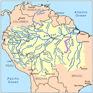
The Iriri River (Portuguese: Rio Iriri, Portuguese pronunciation: [ˈɦiu iɾiˈɾi]; Mẽbêngôkre: Kororoti, [kɔˌɾɔɾɔˈti][1]: 40 ) is a large tributary of the Xingu River in Brazil, in the state of Pará. It is 1,300 km (810 mi) long making it the 116th longest river in the world (with Krishna River, India) and the 15th longest in the Amazon basin. The headwaters are the traditional home of the Panará people.
| Iriri River | |
|---|---|
 | |
| Native name |
|
| Location | |
| Country | Brazil |
| Physical characteristics | |
| Source | |
| • location | Pará, Brazil |
| • elevation | 619 m (2,031 ft) |
| Mouth | Xingu River |
• coordinates | 3°49′00″S 52°36′20″W |
• elevation | 116 m (381 ft) |
| Length | 1,151 km (715 mi)[2] |
| Basin size | 141,943 km2 (54,804 sq mi)[2] |
| Discharge | |
| • location | Confluence of Xingu (near mouth) |
| • average | 3,028 m3/s (106,900 cu ft/s)[2] |
| • minimum | 56.3 m3/s (1,990 cu ft/s)[2] |
| • maximum | 14,025 m3/s (495,300 cu ft/s)[2] |
| Discharge | |
| • location | Pedra do Ó gauge station (130 km upstream of mouth - Basin size 123,827 km2 (47,810 sq mi) |
| • average | 2,748 m3/s (97,000 cu ft/s)[2] |
| • minimum | 49 m3/s (1,700 cu ft/s)[2] |
| • maximum | 12,235 m3/s (432,100 cu ft/s)[2] |
| Basin features | |
| Tributaries | |
| • left | Curuá River, Catete River, Chiché River, Ipiranga River |
| • right | Novo River, Carajarí River, Xinxim River, Iriri Novo River |
Course
The river rises in the 342,192 hectares (845,570 acres) Nascentes da Serra do Cachimbo Biological Reserve, a strictly protected conservation unit established in 2005 in the Serra do Cachimbo. It is one of the headwaters of the Xingu River.[3] It flows for 900 kilometres (560 mi) before joining the Xingu, running through the 3,373,133.89 hectares (8,335,195.4 acres) Terra do Meio Ecological Station. The river varies greatly in volume depending on the season, and in the dry season include waterfalls, rocks and rapids.[4]
The Iriri River flows through the Tapajós–Xingu moist forests ecoregion.[5] The river is rich in fish, including many species found only here and in the Xingu. Large sections remain unexplored due to its remoteness in a region surrounded by Amazon rainforest, and sections with strong current and cataracts.[6]
References
- Passos, João Lucas Moraes (2018). Caminhos mẽbêngôkre: andando, nomeando, sentando sobre a terra (Ph.D. thesis). Brasília: Universidade de Brasília.
- "Conhecimento Técnico e a regulação ambiental na Amazônia: A utilização da bacia hidrográfica nos EIA/RIMA das UHE do Rio Madeira e de Belo Monte". 2015.
- Unidade de Conservação: Reserva Biológica...
- Unidade de Conservação: Estação Ecológica ...
- Sears.
- Bleher 2009.
Sources
- Bleher, H. (2009), "Rio Iriri biotope, Brazil.", Practical Fishkeeping, archived from the original on 27 May 2014, retrieved 26 May 2014
- Sears, Robin, Amazon Basin - Brazil (NT0168), WWF: World Wildlife Fund, retrieved 2017-03-20
- Unidade de Conservação: Estação Ecológica da Terra do Meio (in Portuguese), MMA: Ministério do Meio Ambiente, archived from the original on 2018-10-01, retrieved 2016-05-29
- Unidade de Conservação: Reserva Biológica Nascentes Serra do Cachimbo (in Portuguese), MMA: Ministério do Meio Ambiente, retrieved 2016-05-27
- Ziesler, R.; Ardizzone, G.D. (1979), "Amazon River System", The Inland waters of Latin America, Food and Agriculture Organization of the United Nations, ISBN 92-5-000780-9, archived from the original on 21 October 2013
На других языках
[de] Rio Iriri
Der Rio Iriri ist ein linker Nebenfluss des Rio Xingu in Brasilien und etwa 1.300 km lang.- [en] Iriri River
[es] Río Iriri
El río Iriri es un largo río amazónico brasileño, el principal afluente del río Xingú. Discurre por el estado brasileño de Pará, y tiene una longitud total de 1050 km.[1][it] Iriri
L'Iriri è un fiume del Brasile nello Stato di Pará ed è un affluente del fiume Xingu.[ru] Ирири
Ирири́[1] (порт. Iriri)[источник не указан 22 дня] — река в Бразилии, левый приток реки Шингу[1]. Протекает в центральной части Южной Америки.Другой контент может иметь иную лицензию. Перед использованием материалов сайта WikiSort.org внимательно изучите правила лицензирования конкретных элементов наполнения сайта.
WikiSort.org - проект по пересортировке и дополнению контента Википедии