geo.wikisort.org - River
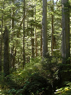
The Incomappleux River is a major tributary of the Columbia River in British Columbia, Canada, entering that river via the Beaton Arm of Upper Arrow Lake. The upper reaches of the river valley are home to a portion of the only inland temperate rainforest in the world.
| Incomappleux River | |
|---|---|
 The inland temperate rainforest of the Incomappleux River Valley | |
| Location | |
| Country | Canada |
| Province | British Columbia |
| District | Kootenay Land District |
| Physical characteristics | |
| Source | Illecillewaet Neve |
| • location | Selkirk Mountains |
| Mouth | Columbia River |
• location | Upper Arrow Lake |
• coordinates | 50°45′N 117°43′W[1] |
| Basin size | 1,020 km2 (390 sq mi)[2] |
| Discharge | |
| • location | near Beaton[2] |
| • average | 55.8 m3/s (1,970 cu ft/s)[2] |
| • minimum | 4.76 m3/s (168 cu ft/s) |
| • maximum | 570 m3/s (20,000 cu ft/s) |
| Basin features | |
| Progression | Incomappleux Valley |
First Nations
The name "Incomappleux" is derived from the Okanagan word nk'mapeleqs, meaning "point at end (of lake)". This refers to the northeastern tip of Upper Arrow Lake into which the Incomappleux River empties. The names of the creek and adjacent mountain are also derived from this word. A Sinixt village by this name formerly existed somewhere in the confluence area.[3]
European settlement
Early explorers referred to the valley and river as various English spellings of the word, but Fish River was also used.[3]
Course
The river's course is nearly due south from its origin in the Selkirk Mountains at the southwest toe of the Illecillewaet Neve on Mount Bonney, which is on the south side of the Rogers Pass and is also the source of the Illecillewaet River.
See also
- Glacier National Park
References
- "Incomappleux River". BC Geographical Names.
- "Archived Hydrometric Data Search". Water Survey of Canada. Archived from the original on February 21, 2009. Retrieved October 19, 2008. Search for Station 08NE001 Incomappleux River near Beaton
- "Nelson Star, 1 Dec 2013". www.nelsonstar.com.
External links
 Media related to Incomappleux River at Wikimedia Commons
На других языках
[de] Incomappleux River
Der Incomappleux River ist ein 67 km langer Fluss im Osten der kanadischen Provinz British Columbia.- [en] Incomappleux River
Другой контент может иметь иную лицензию. Перед использованием материалов сайта WikiSort.org внимательно изучите правила лицензирования конкретных элементов наполнения сайта.
WikiSort.org - проект по пересортировке и дополнению контента Википедии
